
Make a donation
Gear up for your next adventure:
As an Amazon Associate, this site earns from qualifying purchases at no extra cost to you.
Bad Hindelang topographic map
Click on the map to display elevation.
Make a donation
Gear up for your next adventure:
As an Amazon Associate, this site earns from qualifying purchases at no extra cost to you.
Bad Hindelang
Das Gemeindegebiet erstreckt sich in einer Höhenlage von 780 m (Ostrachbrücke bei Reckenberg) bis auf 2592 m (Hochvogel).
Make a donation
Gear up for your next adventure:
As an Amazon Associate, this site earns from qualifying purchases at no extra cost to you.
About this map
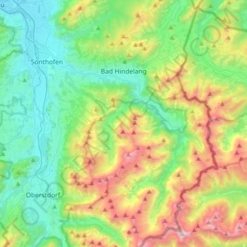
Name: Bad Hindelang topographic map, elevation, terrain.
Average elevation: 4,180 ft
Minimum elevation: 2,339 ft
Maximum elevation: 8,402 ft
Make a donation
Gear up for your next adventure:
As an Amazon Associate, this site earns from qualifying purchases at no extra cost to you.
Other topographic maps
Click on a map to view its topography, its elevation and its terrain.
Steibis
Deutschland > Bayern > Landkreis Oberallgäu
Steibis ist ein Ortsteil in der Gemarkung Aach im Allgäu des Marktes Oberstaufen im bayerisch-schwäbischen Landkreis Oberallgäu. Es liegt auf einer leicht abfallenden Hochebene zwischen dem nördlichen Weissachtal und der südlich liegenden Hochgratkette auf einer Höhe von 860 m. Hausberge sind der…
Average elevation: 2,867 ft
Oberschwarzenberg
Deutschland > Bayern > Landkreis Oberallgäu > Oy-Mittelberg > Unterschwarzenberg
Average elevation: 2,920 ft
Nebelhorn
Deutschland > Bayern > Landkreis Oberallgäu > Oberstdorf
Die Schartenhöhe des Nebelhorns beträgt mindestens 24 Meter, seine Dominanz 500 Meter, wobei jeweils der Westliche Wengenkopf Referenzberg ist.
Average elevation: 5,879 ft
Wäldle
Deutschland > Bayern > Landkreis Oberallgäu > Balderschwang > Balderschwang
Average elevation: 4,252 ft
Make a donation
Gear up for your next adventure:
As an Amazon Associate, this site earns from qualifying purchases at no extra cost to you.
Vorderhindelang
Deutschland > Bayern > Landkreis Oberallgäu > Bad Hindelang
Average elevation: 3,392 ft
Make a donation
Gear up for your next adventure:
As an Amazon Associate, this site earns from qualifying purchases at no extra cost to you.
Make a donation
Gear up for your next adventure:
As an Amazon Associate, this site earns from qualifying purchases at no extra cost to you.
Make a donation
Gear up for your next adventure:
As an Amazon Associate, this site earns from qualifying purchases at no extra cost to you.
Make a donation
Gear up for your next adventure:
As an Amazon Associate, this site earns from qualifying purchases at no extra cost to you.
Freibergsee
Deutschland > Bayern > Landkreis Oberallgäu
Der Freibergsee liegt im Süden von Oberstdorf, der südlichsten Gemeinde Deutschlands, im Landkreis Oberallgäu in Bayern in 930 m Höhe auf dem bewaldeten Freiberg.
Average elevation: 3,268 ft
Make a donation
Gear up for your next adventure:
As an Amazon Associate, this site earns from qualifying purchases at no extra cost to you.
Make a donation
Gear up for your next adventure:
As an Amazon Associate, this site earns from qualifying purchases at no extra cost to you.
Großer Alpsee
Deutschland > Bayern > Landkreis Oberallgäu > Immenstadt im Allgäu > Bühl am Alpsee
Weniger als 200 Meter oberhalb des westlichen Ufers liegt der 4,6 ha große Teufelssee, ein Restgewässer aus der Zeit, als der See noch weiter nach Westen reichte. Er liegt im Naturpark Nagelfluhkette und grenzt im Norden an den Salmaser Höhenzug, der die nördliche Grenze der Allgäuer Alpen darstellt. Im…
Average elevation: 2,694 ft
Gunzesried
Deutschland > Bayern > Landkreis Oberallgäu
Gunzesried ist ein Dorf und Ortsteil der bayerischen Gemeinde Blaichach im Allgäu. Er liegt in knapp 900 m Höhe in einem Hochtal.
Average elevation: 3,255 ft
Make a donation
Gear up for your next adventure:
As an Amazon Associate, this site earns from qualifying purchases at no extra cost to you.
Unterjoch
Deutschland > Bayern > Landkreis Oberallgäu > Bad Hindelang
Unterjoch ist ein Ortsteil des Marktes Bad Hindelang mit ungefähr 420 Einwohnern, der auf einer Höhe von 1013 m über NN liegt. Er ist heute touristisch geprägt.
Average elevation: 3,894 ft
Thaler Höhe
Deutschland > Bayern > Landkreis Oberallgäu > Missen-Wilhams
Die Thaler Höhe ist ein 1167 m ü. NHN hoher Nebengipfel der Salmaser Höhe in den Allgäuer Alpen oder wahlweise im Bayerischen Alpenvorland, da die beiden Naturräume nicht einheitlich voneinander abgegrenzt werden. Sie liegt im Landkreis Oberallgäu in der Gemarkung der Gemeinde Missen-Wilhams.
Average elevation: 3,248 ft
Make a donation
Gear up for your next adventure:
As an Amazon Associate, this site earns from qualifying purchases at no extra cost to you.
Emmereis
Deutschland > Bayern > Landkreis Oberallgäu > Rettenberg > Vorderburg
Average elevation: 2,936 ft
Make a donation
Gear up for your next adventure:
As an Amazon Associate, this site earns from qualifying purchases at no extra cost to you.
Tiefenbach
Deutschland > Bayern > Landkreis Oberallgäu > Oberstdorf > Tiefenbach
Average elevation: 3,186 ft
Make a donation
Gear up for your next adventure:
As an Amazon Associate, this site earns from qualifying purchases at no extra cost to you.
Hintersteiner Tal
Deutschland > Bayern > Landkreis Oberallgäu > Bad Hindelang
Average elevation: 4,593 ft
Oberstdorf
Deutschland > Bayern > Landkreis Oberallgäu > Oberstdorf > Oberstdorf
Average elevation: 3,602 ft
Knottenried
Deutschland > Bayern > Landkreis Oberallgäu > Immenstadt im Allgäu
Der Höhenfestpunkt für Knottenried ist in die Mauer der Pfarrkirche eingeschlagen und liegt auf 1003 m über NHN. Der mit 1056 m ü. NHN höchste Punkt der Pfarrei ist westlich von Knottenried auf der im amtlichen Grundbeschrieb als „Prageck“ benannten Flurbezeichnung. Der tiefste Punkt ist das…
Average elevation: 3,110 ft
Make a donation
Gear up for your next adventure:
As an Amazon Associate, this site earns from qualifying purchases at no extra cost to you.
Make a donation
Gear up for your next adventure:
As an Amazon Associate, this site earns from qualifying purchases at no extra cost to you.
Obergschwend
Deutschland > Bayern > Landkreis Oberallgäu > Bad Hindelang > Unterjoch
Average elevation: 4,055 ft
Make a donation
Gear up for your next adventure:
As an Amazon Associate, this site earns from qualifying purchases at no extra cost to you.
Make a donation
Gear up for your next adventure:
As an Amazon Associate, this site earns from qualifying purchases at no extra cost to you.
Make a donation
Gear up for your next adventure:
As an Amazon Associate, this site earns from qualifying purchases at no extra cost to you.
Ofterschwanger Horn
Deutschland > Bayern > Landkreis Oberallgäu > Ofterschwang
Average elevation: 3,796 ft
Buchenegger Wasserfälle
Deutschland > Bayern > Landkreis Oberallgäu > Oberstaufen
Average elevation: 3,028 ft
Make a donation
Gear up for your next adventure:
As an Amazon Associate, this site earns from qualifying purchases at no extra cost to you.
Make a donation
Gear up for your next adventure:
As an Amazon Associate, this site earns from qualifying purchases at no extra cost to you.
Schochen
Deutschland > Bayern > Landkreis Oberallgäu > Oberstdorf
Die Schartenhöhe des Schochens beträgt mindestens 60 Meter, seine Dominanz 800 Meter, wobei jeweils der Lachenkopf Referenzberg ist.
Average elevation: 5,390 ft
Make a donation
Gear up for your next adventure:
As an Amazon Associate, this site earns from qualifying purchases at no extra cost to you.
Make a donation
Gear up for your next adventure:
As an Amazon Associate, this site earns from qualifying purchases at no extra cost to you.
Make a donation
Gear up for your next adventure:
As an Amazon Associate, this site earns from qualifying purchases at no extra cost to you.
Make a donation
Gear up for your next adventure:
As an Amazon Associate, this site earns from qualifying purchases at no extra cost to you.
Bühl am Alpsee
Deutschland > Bayern > Landkreis Oberallgäu > Immenstadt im Allgäu
Average elevation: 2,963 ft
Make a donation
Gear up for your next adventure:
As an Amazon Associate, this site earns from qualifying purchases at no extra cost to you.
Obermaiselstein
Deutschland > Bayern > Landkreis Oberallgäu
Der Hauptort liegt auf 849 m Höhe (Kirchplatz). Die höchsten Erhebungen sind das Riedberger Horn mit 1787 Meter und der Besler mit 1679 Meter. Die tiefsten Stellen liegen im Talholz und am Riedbach unterhalb der Lochleite. Etwa 60 Prozent der Gemeindefläche von 2500 Hektar wird alp- oder forstwirtschaftlich…
Average elevation: 4,180 ft
Make a donation
Gear up for your next adventure:
As an Amazon Associate, this site earns from qualifying purchases at no extra cost to you.
Immenstadt im Allgäu
Deutschland > Bayern > Landkreis Oberallgäu > Immenstadt im Allgäu
Average elevation: 2,986 ft
Make a donation
Gear up for your next adventure:
As an Amazon Associate, this site earns from qualifying purchases at no extra cost to you.