
Rajasthan topographic map
Interactive map
Click on the map to display elevation.
About this map
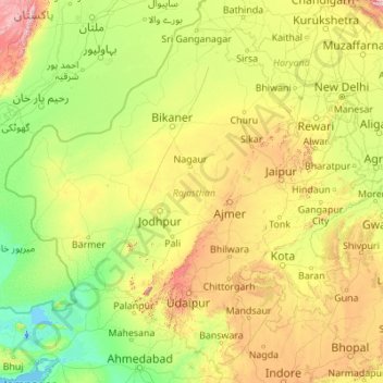
Name: Rajasthan topographic map, elevation, terrain.
Location: Rajasthan, India (23.05938 69.48444 30.19825 78.27201)
Average elevation: 833 ft
Minimum elevation: -16 ft
Maximum elevation: 7,543 ft
The Aravalli Range runs across the state from the southwest peak Guru Shikhar (Mount Abu), which is 1,722 metres (5,650 ft) in height, to Khetri in the northeast. This range divides the state into 60% in the northwest of the range and 40% in the southeast. The northwest tract is sandy and unproductive with little water but improves gradually from desert land in the far west and northwest to comparatively fertile and habitable land towards the east. The area includes the Thar Desert. The south-eastern area, higher in elevation (100 to 350 m above sea level) and more fertile, has a very diversified topography. In the south lies the hilly tract of Mewar. In the southeast, a large area within the districts of Kota and Bundi forms a tableland. To the northeast of these districts is a rugged region (badlands) following the line of the Chambal River. Farther north the country levels out; the flat plains of the northeastern Bharatpur district are part of an alluvial basin. Merta City lies in the geographical center of Rajasthan.
Other topographic maps
Click on a map to view its topography, its elevation and its terrain.
3d
India > Rajasthan > Ganganagar Tehsil > 1 LNP
3d, 1 LNP, Ganganagar Tehsil, Sri Ganganagar District, Rajasthan, India
Average elevation: 584 ft
Sengipatti
India > Tamil Nadu > Thanjavur
Sengipatti, Thanjavur, Thanjavur District, Tamil Nadu, India
Average elevation: 259 ft
Ramchandrapuram
India > Andhra Pradesh > A.Konduru
Ramchandrapuram, A.Konduru, NTR, Andhra Pradesh, India
Average elevation: 322 ft
Simandhar Tenements & Flats
India > Gujarat > Mahesana Taluka
Simandhar Tenements & Flats, Mahesana Taluka, Mahesana District, Gujarat, 384001, India
Average elevation: 285 ft
Kadungalloor
India > Kerala > Paravur > Edayar
Kadungalloor, Edayar, Paravur, Ernakulam District, Kerala, India
Average elevation: 26 ft
Shast
India > Himachal Pradesh > Kotkhai
Shast, Kotkhai, Shimla District, Himachal Pradesh, 171204, India
Average elevation: 7,516 ft
Shivpuri District
Shivpuri District, Madhya Pradesh, India
Average elevation: 1,184 ft
Haraluru
India > Karnataka > Tumkur taluk
Haraluru, Tumkur taluk, Tumakuru District, Karnataka, India
Average elevation: 2,835 ft
Duldula
India > Chhattisgarh > Duldula Tahsil
Duldula, Duldula Tahsil, Jashpur District, Chhattisgarh, 496334, India
Average elevation: 1,739 ft
Jodhpur
India > Rajasthan > Jodhpur Tehsil
Jodhpur, Jodhpur Tehsil, Jodhpur District, Rajasthan, India
Average elevation: 781 ft
Boroonda
India > Rajasthan > Pipar City Tehsil
Boroonda, Pipar City Tehsil, Jodhpur(Rural) District, Rajasthan, India
Average elevation: 1,004 ft
Gubbalala
India > Karnataka > Bangalore South
Gubbalala, Bangalore South, Bengaluru Urban, Karnataka, 560062, India
Average elevation: 2,871 ft
Gairan Wasti
India > Maharashtra > Dharashiv > Waruda
Gairan Wasti, Waruda, Dharashiv, Dharashiv District, Maharashtra, India
Average elevation: 2,175 ft
Indian subcontinent
India > Maharashtra > Arni
Indian subcontinent, Arni, Yavatmal, Maharashtra, India
Average elevation: 1,155 ft
Shadnagar
India > Telangana > Farooqnagar mandal
Shadnagar, Farooqnagar mandal, Ranga Reddy District, Telangana, 509216, India
Average elevation: 2,073 ft
Tamluk
Tamluk, Purba Medinipur District, West Bengal, India
Average elevation: 13 ft
Digdoh
India > Maharashtra > Nagpur Urban Taluka
Digdoh, Nagpur Urban Taluka, Nagpur District, Maharashtra, 440019, India
Average elevation: 1,070 ft
Sonbhadra
India > Bihar > Sonbhadra Banshi Suryapur
Sonbhadra, Sonbhadra Banshi Suryapur, Arwal District, Bihar, 824120, India
Average elevation: 243 ft
Sulai
India > Rajasthan > Kherwara Tehsil
Sulai, Kherwara Tehsil, Udaipur District, Rajasthan, India
Average elevation: 1,296 ft
Nipani
India > Maharashtra > Chhatrapati Sambhajinagar
Nipani, Chhatrapati Sambhajinagar, Chhatrapati Sambhajinagar District, Maharashtra, 431007, India
Average elevation: 1,837 ft
Dehradun
India > Uttarakhand > Dehradun
Dehradun, Dehradun District, Uttarakhand, 248001, India
Average elevation: 2,966 ft
Neamatpur
India > West Bengal > Goalpokhar - II
Neamatpur, Goalpokhar - II, Uttar Dinajpur District, West Bengal, India
Average elevation: 131 ft
Holalkere
India > Karnataka > Holalkere taluk
Holalkere, Holalkere taluk, Chitradurga District, Karnataka, 577526, India
Average elevation: 2,346 ft
Model Town Tehsil
Model Town Tehsil, North Delhi District, Delhi, India
Average elevation: 696 ft
Chandrashila
India > Uttarakhand > Pokhari > Bhulkhana Chatti
Chandrashila, NH107A, Bhulkhana Chatti, Pokhari, Chamoli District, Uttarakhand, India
Average elevation: 10,236 ft
Chikkabidarakallu
India > Karnataka > Bangalore North
Chikkabidarakallu, Bangalore North, Bengaluru Urban, Karnataka, 560073, India
Average elevation: 2,877 ft
Chatri Nizampur
India > Maharashtra > Mahad
Chatri Nizampur, Mahad, Raigad District, Maharashtra, 402104, India
Average elevation: 1,083 ft
Benital
India > Uttarakhand > Karnaprayag
Benital, Karnaprayag, Chamoli District, Uttarakhand, India
Average elevation: 6,070 ft
Wawana
India > Maharashtra > Phulambri
Wawana, Phulambri, Chhatrapati Sambhajinagar District, Maharashtra, India
Average elevation: 2,234 ft
Parbatpur
India > Madhya Pradesh > Sironj Tahsil > Kamariya
Parbatpur, Kamariya, Sironj Tahsil, Vidisha District, Madhya Pradesh, India
Average elevation: 1,627 ft
Songadh
India > Gujarat > Songadh Taluka
Songadh, Songadh Taluka, Tapi District, Gujarat, 394670, India
Average elevation: 407 ft
Mandirbazar
Mandirbazar, South 24 Parganas District, West Bengal, 743336, India
Average elevation: 13 ft
Nankhari
Nankhari, Shimla District, Himachal Pradesh, 172021, India
Average elevation: 6,732 ft
Jabalpur
India > Madhya Pradesh > Ranjhi Tahsil
Jabalpur, Ranjhi Tahsil, Jabalpur District, Madhya Pradesh, India
Average elevation: 1,339 ft
Alamboo
India > Rajasthan > Kekri Tehsil
Alamboo, Kekri Tehsil, Ajmer District, Rajasthan, India
Average elevation: 1,165 ft
Chichkheda
India > Madhya Pradesh > Pandhurna Tahsil
Chichkheda, Pandhurna Tahsil, Pandhurna District, Madhya Pradesh, India
Average elevation: 1,663 ft
Morshing
India > Arunachal Pradesh > Kalaktang ADC
Morshing, Kalaktang ADC, West Kameng District, Arunachal Pradesh, India
Average elevation: 7,615 ft
Naggar
India > Himachal Pradesh > Kullu
Naggar, Kullu, Kullu District, Himachal Pradesh, 175130, India
Average elevation: 6,699 ft
Panchgani
India > Maharashtra > Mahabaleshwar
Panchgani, Mahabaleshwar, Satara, Maharashtra, 412805, India
Average elevation: 3,343 ft