
Village of Mamaroneck topographic map
Interactive map
Click on the map to display elevation.
Village of Mamaroneck
Other areas of the town include Heathcote Hill, overlooking the harbor, Harbor Heights (the heights) to the northeast, Old Rye Neck (settled in the 1880s), Rye Neck (settled in the 1920s and 1930s), Orienta, and Washingtonville, better known as "The Flats", due to the flat, low-lying topography of the area.
About this map
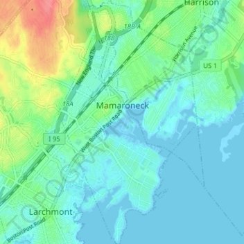
Name: Village of Mamaroneck topographic map, elevation, terrain.
Average elevation: 49 ft
Minimum elevation: -10 ft
Maximum elevation: 213 ft
Westchester County trails, hiking, mountain biking, running and outdoor activities
Other topographic maps
Click on a map to view its topography, its elevation and its terrain.
Ward Pound Ridge Reservation
United States > New York > Westchester County > Town of Pound Ridge
Average elevation: 538 ft
Riveredge Trailer Park
United States > New York > Westchester County > Town of Cortlandt > Verplanck
Average elevation: 46 ft
Isle of San Souci
United States > New York > Westchester County > City of New Rochelle
Average elevation: 23 ft
Wykagyl Park
United States > New York > Westchester County > City of New Rochelle
Average elevation: 135 ft
Lake Waccabuc
United States > New York > Westchester County > Town of Lewisboro > Waccabuc
Average elevation: 568 ft
Sherman Park
United States > New York > Westchester County > Town of Mount Pleasant > Thornwood
Average elevation: 436 ft
Mariandale
United States > New York > Westchester County > Village of Ossining
Average elevation: 174 ft
Pleasantside
United States > New York > Westchester County > Town of Cortlandt
Average elevation: 354 ft
Salem Center
United States > New York > Westchester County > Town of North Salem
Average elevation: 482 ft
Bonnie Crest
United States > New York > Westchester County > City of New Rochelle
Average elevation: 190 ft
Vernon Park
United States > New York > Westchester County > City of Mount Vernon
Average elevation: 102 ft
Lake Mohansic
United States > New York > Westchester County > Town of Yorktown
Average elevation: 522 ft
West Harrison Village Green
United States > New York > Westchester County > Town/Village of Harrison > East White Plains
Average elevation: 259 ft
Colonial Heights
United States > New York > Westchester County > City of Yonkers
Average elevation: 197 ft
Sedge Island
United States > New York > Westchester County > City of New Rochelle
Average elevation: 154 ft
Crestwood Gardens
United States > New York > Westchester County > City of Yonkers
Average elevation: 213 ft
Jefferson Valley
United States > New York > Westchester County > Jefferson Valley-Yorktown
Average elevation: 584 ft
Gunther Park
United States > New York > Westchester County > City of Yonkers
Average elevation: 184 ft
Chauncey
United States > New York > Westchester County > Village of Dobbs Ferry
Average elevation: 249 ft
Fenmore Park
United States > New York > Westchester County > Town/Village of Harrison
Average elevation: 125 ft
Shore Acres
United States > New York > Westchester County > Village of Mamaroneck
Average elevation: 36 ft
Bronxville Heights
United States > New York > Westchester County > City of Yonkers
Average elevation: 207 ft
Mount Hope
United States > New York > Westchester County > Village of Hastings-on-Hudson
Average elevation: 197 ft
Ridgeway
United States > New York > Westchester County > City of White Plains
Average elevation: 249 ft
Wykagyl
United States > New York > Westchester County > City of New Rochelle
Average elevation: 151 ft
New York, Westchester and Boston Railway
United States > New York > Westchester County > Village of Pelham > North Pelham
Average elevation: 92 ft
Sleepy Hollow Manor
United States > New York > Westchester County > Village of Sleepy Hollow > Sleepy Hollow Manor
Average elevation: 135 ft
Spring Valley
United States > New York > Westchester County > Town of Ossining > Ossining > Spring Valley
Average elevation: 377 ft
Whitehall Corners
United States > New York > Westchester County > Town of Somers
Average elevation: 318 ft
Sarles Corners
United States > New York > Westchester County > Town of Pound Ridge
Average elevation: 463 ft
Secor Gardens
United States > New York > Westchester County > Village of Scarsdale
Average elevation: 230 ft