
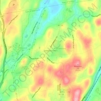
Tompkins Corners topographic map
Interactive map
Click on the map to display elevation.
About this map
Name: Tompkins Corners topographic map, elevation, terrain.
Average elevation: 466 ft
Minimum elevation: 220 ft
Maximum elevation: 715 ft
Westchester County trails, hiking, mountain biking, running and outdoor activities
Other topographic maps
Click on a map to view its topography, its elevation and its terrain.
Ward Pound Ridge Reservation
United States > New York > Westchester County > Town of Pound Ridge
Average elevation: 538 ft
Titicus Reservoir
United States > New York > Westchester County > Town of North Salem > Salem Center
Average elevation: 420 ft
Harbor Island Park
United States > New York > Westchester County > Town of Mamaroneck > Orienta
Average elevation: 33 ft
Lake Waccabuc
United States > New York > Westchester County > Town of Lewisboro > Waccabuc
Average elevation: 568 ft
Bedford Hills
United States > New York > Westchester County > Town of Bedford
Bedford Hills is located at 41°14′12″N 073°41′40″W / 41.23667°N 73.69444°W / 41.23667; -73.69444 (41.2367613, -73.6945751) and its elevation is 341 feet (104 m).
Average elevation: 384 ft
Village of Tuckahoe
United States > New York > Westchester County > Town of Eastchester
Average elevation: 187 ft
Thornwood
United States > New York > Westchester County > Town of Mount Pleasant
Average elevation: 397 ft
Village of Mamaroneck
United States > New York > Westchester County
Other areas of the town include Heathcote Hill, overlooking the harbor, Harbor Heights (the heights) to the northeast, Old Rye Neck (settled in the 1880s), Rye Neck (settled in the 1920s and 1930s), Orienta, and Washingtonville, better known as "The Flats", due to the flat, low-lying topography of the area.
Average elevation: 49 ft
Goldens Bridge
United States > New York > Westchester County > Town of Lewisboro
Average elevation: 308 ft
Lake Mohansic
United States > New York > Westchester County > Town of Yorktown
Average elevation: 522 ft
Hawthorne
United States > New York > Westchester County > Town of Mount Pleasant
Average elevation: 374 ft
West Harrison Village Green
United States > New York > Westchester County > Town/Village of Harrison > East White Plains
Average elevation: 259 ft
Village of Briarcliff Manor
United States > New York > Westchester County
The village is a part of the Pocantico and Saw Mill River Basin and the Lower Hudson River Drainage Basin,[32] which leads to the Hudson west-southwest of the village. Major streams running through Briarcliff Manor include the centrally-located Caney Brook, the Pocantico River, and Sparta Brook. Abundant rock…
Average elevation: 374 ft
Village of Bronxville
United States > New York > Westchester County > Town of Eastchester
Average elevation: 157 ft
New York, Westchester and Boston Railway
United States > New York > Westchester County > Village of Pelham > North Pelham
Average elevation: 92 ft
Valhalla
United States > New York > Westchester County > Town of Mount Pleasant
Average elevation: 358 ft
Town of Ossining
United States > New York > Westchester County > Town of Ossining
Average elevation: 213 ft
Village of Pelham Manor
United States > New York > Westchester County > Town of Pelham
Average elevation: 52 ft