Geolocate

Dego topographic map

Click on the map to display elevation.

About this map

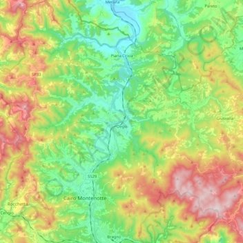
Name: Dego topographic map, elevation, terrain.

Location: Dego, Savona, Liguria, 17058, Italy (44.40035 8.19622 44.49113 8.40373)

Average elevation: 1,565 ft

Minimum elevation: 807 ft

Maximum elevation: 2,799 ft

Other topographic maps

Click on a map to view its topography, its elevation and its terrain.

Vara Inferiore

Italy > Liguria > Savona

Average elevation: 2,602 ft

Vara Superiore

Italy > Liguria > Savona

Average elevation: 2,687 ft

Biestro

Italy > Liguria > Savona > Pallare

Average elevation: 1,906 ft

Gear up for your next adventure:

🥩Freeze-Dried Meals - Nutritious and lightweight food for remote expeditions
🧭Orienteering Set - Complete compass and map reading kit
🗻Climbing Gear Basics - Essential gear for beginner climbers
🔦LED Headlamp - Bright and durable LED headlamp for night navigation
🧯Emergency Survival Kit - All‑in‑one survival essentials for the backcountry

As an Amazon Associate, this site earns from qualifying purchases at no extra cost to you.