
Make a donation
Gear up for your next adventure:
As an Amazon Associate, this site earns from qualifying purchases at no extra cost to you.
Bad Gastein topographic map
Click on the map to display elevation.
Make a donation
Gear up for your next adventure:
As an Amazon Associate, this site earns from qualifying purchases at no extra cost to you.
Bad Gastein
Bad Gastein has a humid continental climate (Dfb) bordering on a subarctic climate (Dfc) due to the town's high elevation. Summers are mild, sometimes warm with cool, refreshing nights. Winters are moderately cold and snowy, with annual snowfall averaging 345 cm (136 inches).
Make a donation
Gear up for your next adventure:
As an Amazon Associate, this site earns from qualifying purchases at no extra cost to you.
About this map
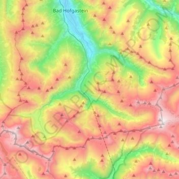
Name: Bad Gastein topographic map, elevation, terrain.
Location: Bad Gastein, Salzburg, 5640, Austria (47.01341 13.00051 47.16039 13.27731)
Average elevation: 6,329 ft
Minimum elevation: 2,733 ft
Maximum elevation: 10,469 ft
Make a donation
Gear up for your next adventure:
As an Amazon Associate, this site earns from qualifying purchases at no extra cost to you.
Other topographic maps
Click on a map to view its topography, its elevation and its terrain.
Make a donation
Gear up for your next adventure:
As an Amazon Associate, this site earns from qualifying purchases at no extra cost to you.
Hinterglemm
Austria > Salzburg > Bezirk Zell am See > Saalbach-Hinterglemm
Average elevation: 4,567 ft
Sankt Martin bei Lofer
Austria > Salzburg > Bezirk Zell am See > Gemeinde Sankt Martin bei Lofer
Average elevation: 2,995 ft
Make a donation
Gear up for your next adventure:
As an Amazon Associate, this site earns from qualifying purchases at no extra cost to you.
Wallersee
Austria > Salzburg > Bezirk Salzburg-Umgebung > Seekirchen am Wallersee > Fischtaging
Average elevation: 1,742 ft
Make a donation
Gear up for your next adventure:
As an Amazon Associate, this site earns from qualifying purchases at no extra cost to you.
Strohwolln
Austria > Salzburg > Bezirk Zell am See > Sankt Martin bei Lofer
Average elevation: 3,143 ft
Großvenediger
Austria > Salzburg > Bezirk Zell am See > Neukirchen am Großvenediger
Average elevation: 10,430 ft
Make a donation
Gear up for your next adventure:
As an Amazon Associate, this site earns from qualifying purchases at no extra cost to you.
Großes Wiesbachhorn
Austria > Salzburg > Bezirk Zell am See > Fusch an der Großglocknerstraße
Average elevation: 9,446 ft
Make a donation
Gear up for your next adventure:
As an Amazon Associate, this site earns from qualifying purchases at no extra cost to you.
Alpendorf Dachstein West
Austria > Salzburg > Bezirk Hallein > Annaberg-Lungötz > Annaberg im Lammertal
Average elevation: 3,435 ft
Make a donation
Gear up for your next adventure:
As an Amazon Associate, this site earns from qualifying purchases at no extra cost to you.
Gruberfeldsiedlung
Austria > Salzburg > Bezirk Salzburg-Umgebung > Heuberg
Average elevation: 2,260 ft
Make a donation
Gear up for your next adventure:
As an Amazon Associate, this site earns from qualifying purchases at no extra cost to you.
Make a donation
Gear up for your next adventure:
As an Amazon Associate, this site earns from qualifying purchases at no extra cost to you.
Make a donation
Gear up for your next adventure:
As an Amazon Associate, this site earns from qualifying purchases at no extra cost to you.
Make a donation
Gear up for your next adventure:
As an Amazon Associate, this site earns from qualifying purchases at no extra cost to you.
Schmalenbergham
Austria > Salzburg > Bezirk Zell am See > Saalfelden am Steinernen Meer > Thor
Average elevation: 2,572 ft
Make a donation
Gear up for your next adventure:
As an Amazon Associate, this site earns from qualifying purchases at no extra cost to you.
Königsleiten
Austria > Salzburg > Bezirk Zell am See > Gemeinde Wald im Pinzgau
Average elevation: 5,587 ft
Make a donation
Gear up for your next adventure:
As an Amazon Associate, this site earns from qualifying purchases at no extra cost to you.
Oberweißburg
Austria > Salzburg > Bezirk Tamsweg > Sankt Michael im Lungau
Average elevation: 4,508 ft
Alpendorf
Austria > Salzburg > Bezirk St. Johann im Pongau > Sankt Johann im Pongau
Alpendorf (German for alpine village) is a village and a part of the town St. Johann im Pongau. It is 55 km (34 mi) south of the Austrian city of Salzburg. It is at an altitude of 850 m (2,790 ft) above sea level.
Average elevation: 2,887 ft
Annaberg im Lammertal
Austria > Salzburg > Bezirk Hallein > Annaberg-Lungötz
Average elevation: 3,173 ft
Hohlwegen
Austria > Salzburg > Bezirk Zell am See > Saalfelden am Steinernen Meer
Average elevation: 3,629 ft
Make a donation
Gear up for your next adventure:
As an Amazon Associate, this site earns from qualifying purchases at no extra cost to you.
Achleiten
Austria > Salzburg > Bezirk Salzburg-Umgebung > Hof bei Salzburg
Average elevation: 2,188 ft
Make a donation
Gear up for your next adventure:
As an Amazon Associate, this site earns from qualifying purchases at no extra cost to you.
Make a donation
Gear up for your next adventure:
As an Amazon Associate, this site earns from qualifying purchases at no extra cost to you.
Zauchensee
Austria > Salzburg > Bezirk St. Johann im Pongau > Altenmarkt im Pongau
Average elevation: 5,564 ft
Wald im Pinzgau
Austria > Salzburg > Bezirk Zell am See > Gemeinde Wald im Pinzgau
Average elevation: 3,816 ft
Make a donation
Gear up for your next adventure:
As an Amazon Associate, this site earns from qualifying purchases at no extra cost to you.
Obersulzbachkees
Austria > Salzburg > Bezirk Zell am See > Marktgemeinde Neukirchen am Großvenediger
Average elevation: 9,045 ft
Rohrmoos
Austria > Salzburg > Bezirk St. Johann im Pongau > Mühlbach am Hochkönig
Average elevation: 3,619 ft