
Ennedi-Ouest topographic map
Interactive map
Click on the map to display elevation.
About this map
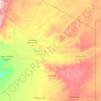
Name: Ennedi-Ouest topographic map, elevation, terrain.
Location: Ennedi-Ouest, Chad (15.74400 19.19121 21.06791 22.35016)
Average elevation: 2,001 ft
Minimum elevation: 591 ft
Maximum elevation: 5,932 ft
Other topographic maps
Click on a map to view its topography, its elevation and its terrain.
Djamena
Chad > Chari-Baguirmi > Mandelia
Djamena, Mandelia, Chari-Baguirmi, Chad
Average elevation: 984 ft
Kabia
Chad > Mayo-Kebbi Est > Gounou Gaya
Kabia, Gounou Gaya, Mayo-Kebbi Est, Chad
Average elevation: 1,145 ft