Geolocate

肖庄户村 topographic map

Interactive map

Click on the map to display elevation.

About this map

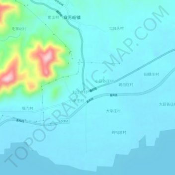
Name: 肖庄户村 topographic map, elevation, terrain.

Location: 肖庄户村, 蓟州区, 天津市, 中国 (40.06156 117.52119 40.10156 117.56119)

Average elevation: 154 ft

Minimum elevation: 52 ft

Maximum elevation: 876 ft

Other topographic maps

Click on a map to view its topography, its elevation and its terrain.

前牛宫村

中国 > 天津市 > 蓟州区

前牛宫村, 蓟州区, 天津市, 中国

Average elevation: 36 ft

许有庄村

中国 > 天津市 > 蓟州区

许有庄村, 蓟州区, 天津市, 中国

Average elevation: 30 ft

侯家营镇

中国 > 天津市 > 蓟州区

侯家营镇, 蓟州区, 天津市, 中国

Average elevation: 30 ft

水泉地

中国 > 天津市 > 蓟州区 > 狐狸峪村

水泉地, 狐狸峪村, 蓟州区, 天津市, 中国

Average elevation: 758 ft

下仓镇

中国 > 天津市 > 蓟州区

下仓镇, 蓟州区, 天津市, 中国

Average elevation: 20 ft

小龙卧村

中国 > 天津市 > 蓟州区

小龙卧村, 蓟州区, 天津市, 中国

Average elevation: 36 ft

三里庄村

中国 > 天津市 > 蓟州区

三里庄村, 蓟州区, 天津市, 301900, 中国

Average elevation: 52 ft

三家店村

中国 > 天津市 > 蓟州区

三家店村, 蓟州区, 天津市, 中国

Average elevation: 210 ft

州河

中国 > 天津市 > 蓟州区

州河, 蓟州区, 天津市, 中国

Average elevation: 23 ft

州河

中国 > 天津市 > 蓟州区

州河, 蓟州区, 蓟县, 天津市, 301900, 中国

Average elevation: 197 ft