Geolocate

Redden topographic map

Click on the map to display elevation.

About this map

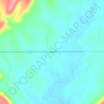
Name: Redden topographic map, elevation, terrain.

Location: Redden, Atoka County, Oklahoma, United States (34.48649 -95.86471 34.52649 -95.82471)

Average elevation: 722 ft

Minimum elevation: 656 ft

Maximum elevation: 1,030 ft

Atoka County trails, hiking, mountain biking, running and outdoor activities

Other topographic maps

Click on a map to view its topography, its elevation and its terrain.

Atoka

United States > Oklahoma > Atoka County

Average elevation: 604 ft

Caney

United States > Oklahoma > Atoka County

Average elevation: 554 ft

Tushka

United States > Oklahoma > Atoka County

Average elevation: 617 ft

Stringtown

United States > Oklahoma > Atoka County

Average elevation: 646 ft

Gear up for your next adventure:

🧤Hiking Gloves - Protective gloves for rugged trails
🧦Merino Wool Socks - Moisture-wicking, blister-preventing socks for long treks
🪑Portable Camp Table - Compact table for campsite meals
🎒Gear Packing Cubes - Organize your backpack efficiently
👖Convertible Hiking Pants - Versatile zip-off pants for changing altitudes and temperatures

As an Amazon Associate, this site earns from qualifying purchases at no extra cost to you.