
Pliening topographic map
Click on the map to display elevation.
About this map
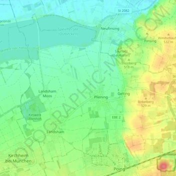
Name: Pliening topographic map, elevation, terrain.
Location: Pliening, Landkreis Ebersberg, Bayern, 85652, Deutschland (48.17427 11.75505 48.22618 11.84715)
Average elevation: 1,663 ft
Minimum elevation: 1,594 ft
Maximum elevation: 1,798 ft
Other topographic maps
Click on a map to view its topography, its elevation and its terrain.
Grafing bei München
Deutschland > Bayern > Landkreis Ebersberg > Grafing bei München > Grafing bei München
Grafing liegt mit einer Arbeitslosenquote von 3,3 % unter dem Durchschnitt des Regierungsbezirks Oberbayern. Die Anzahl der Auspendler in Höhe von 3848 ist auf die Nähe zu München zurückzuführen. Allerdings übernimmt Grafing mit 1623 Einpendlern für die umliegenden Gemeinden die Funktion eines wichtigen…
Average elevation: 1,801 ft
Baldham
Deutschland > Bayern > Landkreis Ebersberg > Vaterstetten
Die Kolonie Baldham wurde vor Beginn des Zweiten Weltkriegs als Standort für das Atelier von Hitlers Bildhauer Josef Thorak gewählt. Das von Albert Speer zwischen 1938 und 1941 errichtete Gebäude (heute Waldstraße 17) besteht aus einem zentralen Baukörper mit einer Höhe von 18 Meter und einer…
Average elevation: 1,795 ft
Höllmühle
Deutschland > Bayern > Landkreis Ebersberg > Grafing bei München > Unterelkofen
Average elevation: 1,755 ft
Dichau
Deutschland > Bayern > Landkreis Ebersberg > Grafing bei München > Straußdorf
Average elevation: 1,768 ft
Gindlkofen
Deutschland > Bayern > Landkreis Ebersberg > Grafing bei München > Grafing-Bahnhof
Average elevation: 1,768 ft
Großrohrsdorf
Deutschland > Bayern > Landkreis Ebersberg > Baiern > Berganger
Average elevation: 1,795 ft
Katzenreuth
Deutschland > Bayern > Landkreis Ebersberg > Grafing bei München
Average elevation: 1,795 ft
Mailing
Deutschland > Bayern > Landkreis Ebersberg > Ebersberg > Oberndorf
Average elevation: 1,831 ft
Jakobneuharting
Deutschland > Bayern > Landkreis Ebersberg > Jakobneuharting
Average elevation: 1,686 ft
Hergolding
Deutschland > Bayern > Landkreis Ebersberg > Vaterstetten > Baldham Dorf
Average elevation: 1,759 ft