
Meadow Vista topographic map
Interactive map
Click on the map to display elevation.
About this map
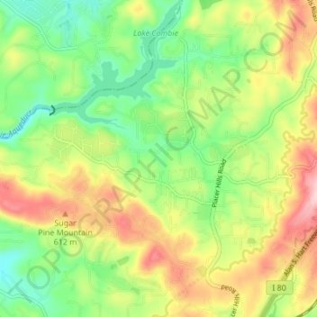
Name: Meadow Vista topographic map, elevation, terrain.
Average elevation: 1,785 ft
Minimum elevation: 1,480 ft
Maximum elevation: 2,201 ft
Other topographic maps
Click on a map to view its topography, its elevation and its terrain.
Lake Tahoe
United States > California > Placer County
Lake Tahoe, Placer County, California, United States
Average elevation: 6,814 ft
Auburn
United States > California > Placer County
Auburn, Placer County, California, 95603, United States
Average elevation: 1,247 ft
Rocklin
United States > California > Placer County
Rocklin, Placer County, California, United States
Average elevation: 312 ft
Granite Bay
United States > California > Placer County
Granite Bay, Placer County, California, 95746, United States
Average elevation: 381 ft
Roseville
United States > California > Placer County
Roseville, Placer County, California, United States
Average elevation: 200 ft
Baxter
United States > California > Placer County
Baxter, Placer County, California, United States
Average elevation: 4,042 ft
Sugar Pine Point
United States > California > Placer County
Sugar Pine Point, Placer County, California, United States
Average elevation: 5,699 ft
Deer Lake
United States > California > Placer County
Deer Lake, Placer County, California, United States
Average elevation: 6,624 ft
Foresthill
United States > California > Placer County
Foresthill, Placer County, California, 95631, United States
Average elevation: 2,818 ft
Loomis
United States > California > Placer County
Loomis, Placer County, California, 95650, United States
Average elevation: 400 ft
North Auburn
United States > California > Placer County
North Auburn, Placer County, California, 95603, United States
Average elevation: 1,453 ft
Avery's Pond
United States > California > Placer County
Avery's Pond, Placer County, California, United States
Average elevation: 620 ft
Colfax
United States > California > Placer County
Colfax, Placer County, California, United States
Average elevation: 2,247 ft
Foresthill
United States > California > Placer County
Foresthill, Placer County, California, 95631, United States
Average elevation: 2,457 ft
Gold Run
United States > California > Placer County
Gold Run, Placer County, California, 95717, United States
Average elevation: 3,051 ft
The Cedars
United States > California > Placer County
The Cedars, Placer County, California, United States
Average elevation: 6,247 ft
Cherry Point
United States > California > Placer County
Cherry Point, Placer County, California, United States
Average elevation: 5,912 ft
Tahoe City
United States > California > Placer County
Tahoe City, Placer County, California, 96145, United States
Average elevation: 6,578 ft
Donner Pass
United States > California > Placer County
Donner Pass, Placer County, CAL Fire Northern Region, California, 96162, United States
Average elevation: 7,100 ft
Applegate
United States > California > Placer County
Applegate, Placer County, California, 95703, United States
Average elevation: 1,929 ft
Olympic Valley
United States > California > Placer County > Olympic Valley
Olympic Valley, Placer County, California, 96146, United States
Average elevation: 6,896 ft
Auburn Ravine
United States > California > Placer County > Auburn
Auburn Ravine, Auburn, Placer County, California, 95658, United States
Average elevation: 814 ft
Carnelian Bay
United States > California > Placer County
Carnelian Bay, Placer County, California, 96140, United States
Average elevation: 6,486 ft
Nyack
United States > California > Placer County
Nyack, Placer County, CAL Fire Northern Region, California, 95715, United States
Average elevation: 5,043 ft
Weimar
United States > California > Placer County
Weimar, Placer County, California, 95736, United States
Average elevation: 2,172 ft
Dollar Point
United States > California > Placer County
Dollar Point, Placer County, California, United States
Average elevation: 6,414 ft
Elders Corner
United States > California > Placer County
Elders Corner, Placer County, California, 95602, United States
Average elevation: 1,368 ft
Iowa Hill
United States > California > Placer County
Iowa Hill, Placer County, California, United States
Average elevation: 2,638 ft
Olympic Valley
United States > California > Placer County
Olympic Valley, Placer County, California, 96146, United States
Average elevation: 6,831 ft
Lincoln
United States > California > Placer County
Lincoln, Placer County, California, United States
Average elevation: 112 ft
Tahoe Vista
United States > California > Placer County > Kings Beach
Tahoe Vista, Kings Beach, Placer County, California, 96148, United States
Average elevation: 6,644 ft
Emigrant Gap
United States > California > Placer County
Emigrant Gap, Placer County, California, 95715, United States
Average elevation: 5,128 ft
French Meadows Reservoir
United States > California > Placer County
French Meadows Reservoir, Placer County, California, United States
Average elevation: 5,843 ft
Blue Canyon
United States > California > Placer County
Blue Canyon, Placer County, California, 95701, United States
Average elevation: 4,764 ft
Lincoln
United States > California > Placer County
Lincoln, Placer County, California, 95648, United States
Average elevation: 197 ft
Alpine Meadows
United States > California > Placer County
Alpine Meadows, Placer County, California, 96146, United States
Average elevation: 7,096 ft
Natural Dam
United States > California > Placer County > Loomis
Natural Dam, Loomis, Placer County, California, 95677, United States
Average elevation: 341 ft
Lincoln
United States > California > Placer County
Lincoln, Placer County, California, 95648, United States
Average elevation: 197 ft
Penryn
United States > California > Placer County
Penryn, Placer County, California, 95663, United States
Average elevation: 597 ft
Snakehead Point
United States > California > Placer County
Snakehead Point, Placer County, California, United States
Average elevation: 2,680 ft
Newcastle
United States > California > Placer County
Newcastle, Placer County, California, 95658, United States
Average elevation: 840 ft
Kings Beach
United States > California > Placer County
Kings Beach, Placer County, California, 96143, United States
Average elevation: 6,414 ft
Cisco
United States > California > Placer County
Cisco, Placer County, California, 95278, United States
Average elevation: 6,093 ft