
Mount Pleasant Township topographic map
Interactive map
Click on the map to display elevation.
About this map
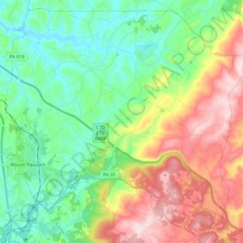
Name: Mount Pleasant Township topographic map, elevation, terrain.
Average elevation: 1,398 ft
Minimum elevation: 951 ft
Maximum elevation: 2,205 ft
Other topographic maps
Click on a map to view its topography, its elevation and its terrain.
Export
United States > Pennsylvania > Westmoreland County > Export
Export, Westmoreland County, Pennsylvania, 15632, United States
Average elevation: 1,122 ft
Fort Allen
United States > Pennsylvania > Westmoreland County > Hempfield Township
Fort Allen, Hempfield Township, Westmoreland County, Pennsylvania, 15697, United States
Average elevation: 1,138 ft
New Kensington
United States > Pennsylvania > Westmoreland County
New Kensington, Westmoreland County, Pennsylvania, 15068, United States
Average elevation: 942 ft
Lower Burrell
United States > Pennsylvania > Westmoreland County
Lower Burrell, Westmoreland County, Pennsylvania, United States
Average elevation: 971 ft
Lynnwood-Pricedale
United States > Pennsylvania > Westmoreland County > Rostraver Township > Pricedale
Lynnwood-Pricedale, Pricedale, Rostraver Township, Westmoreland County, Pennsylvania, 15072, United States
Average elevation: 935 ft
Laurel Mountain
United States > Pennsylvania > Westmoreland County
Laurel Mountain, Westmoreland County, Pennsylvania, 15655, United States
Average elevation: 1,562 ft
Trafford
United States > Pennsylvania > Westmoreland County
Trafford, Westmoreland County, Pennsylvania, United States
Average elevation: 965 ft
Greensburg
United States > Pennsylvania > Westmoreland County
Greensburg, Westmoreland County, Pennsylvania, 15601, United States
Average elevation: 1,158 ft
Southwest Greensburg
United States > Pennsylvania > Westmoreland County
Southwest Greensburg, Westmoreland County, Pennsylvania, United States
Average elevation: 1,086 ft
Manor
United States > Pennsylvania > Westmoreland County
Manor, Westmoreland County, Pennsylvania, 15665, United States
Average elevation: 1,056 ft
Loyalhanna
United States > Pennsylvania > Westmoreland County > Derry Township
Loyalhanna, Derry Township, Westmoreland County, Pennsylvania, 15661, United States
Average elevation: 1,086 ft
Murrysville
United States > Pennsylvania > Westmoreland County
Murrysville, Westmoreland County, Pennsylvania, 15668, United States
Average elevation: 1,129 ft
Monessen
United States > Pennsylvania > Westmoreland County
Monessen, Westmoreland County, Pennsylvania, 15062, United States
Average elevation: 919 ft
New Florence
United States > Pennsylvania > Westmoreland County
New Florence, Westmoreland County, Pennsylvania, United States
Average elevation: 1,135 ft
Forbes Road
United States > Pennsylvania > Westmoreland County > Salem Township
Forbes Road, Salem Township, Westmoreland County, Pennsylvania, 15633, United States
Average elevation: 1,201 ft
Whites Hill
United States > Pennsylvania > Westmoreland County > Hempfield Township
Whites Hill, Hempfield Township, Westmoreland County, Pennsylvania, 15697, United States
Average elevation: 1,063 ft
Penn Township
United States > Pennsylvania > Westmoreland County
Penn Township, Westmoreland County, Pennsylvania, United States
Average elevation: 1,135 ft
Lawson Heights
United States > Pennsylvania > Westmoreland County > Unity Township > Lawson Heights
Lawson Heights, Unity Township, Westmoreland County, Pennsylvania, 15650, United States
Average elevation: 1,047 ft
Ligonier
United States > Pennsylvania > Westmoreland County
Ligonier, Westmoreland County, Pennsylvania, United States
Average elevation: 1,243 ft
Washington Township
United States > Pennsylvania > Westmoreland County
Washington Township, Westmoreland County, Pennsylvania, 15613, United States
Average elevation: 1,175 ft
Jones Mills
United States > Pennsylvania > Westmoreland County > Donegal Township
Jones Mills, Donegal Township, Westmoreland County, Pennsylvania, 15646, United States
Average elevation: 1,716 ft
North Huntingdon Township
United States > Pennsylvania > Westmoreland County
North Huntingdon Township, Westmoreland County, Pennsylvania, United States
Average elevation: 1,066 ft
Oak Grove
United States > Pennsylvania > Westmoreland County > Ligonier Township
Oak Grove, Ligonier Township, Westmoreland County, Pennsylvania, 15658, United States
Average elevation: 1,358 ft
Rostraver Township
United States > Pennsylvania > Westmoreland County
Rostraver Township, Westmoreland County, Pennsylvania, United States
Average elevation: 1,010 ft
Acme
United States > Pennsylvania > Westmoreland County > Mount Pleasant Township
Acme, Mount Pleasant Township, Westmoreland County, Pennsylvania, 15610, United States
Average elevation: 1,919 ft
Scottdale
United States > Pennsylvania > Westmoreland County
Scottdale, Westmoreland County, Pennsylvania, 15683, United States
Average elevation: 1,106 ft
Basforth Acres
United States > Pennsylvania > Westmoreland County > Hempfield Township
Basforth Acres, Hempfield Township, Westmoreland County, Pennsylvania, 15634, United States
Average elevation: 1,243 ft
Smithton
United States > Pennsylvania > Westmoreland County
Smithton, Westmoreland County, Pennsylvania, United States
Average elevation: 945 ft
West Newton
United States > Pennsylvania > Westmoreland County
West Newton, Westmoreland County, Pennsylvania, United States
Average elevation: 928 ft
Reagantown
United States > Pennsylvania > Westmoreland County > South Huntingdon Township
Reagantown, South Huntingdon Township, Westmoreland County, Pennsylvania, 15691, United States
Average elevation: 1,306 ft
Hyde Park
United States > Pennsylvania > Westmoreland County
Hyde Park, Westmoreland County, Pennsylvania, 15641, United States
Average elevation: 925 ft
Salem Township
United States > Pennsylvania > Westmoreland County
Salem Township, Westmoreland County, Pennsylvania, United States
Average elevation: 1,168 ft
Keystone State Park
United States > Pennsylvania > Westmoreland County > Derry Township
Keystone State Park, Derry Township, Westmoreland County, Pennsylvania, United States
Average elevation: 1,155 ft
Derry Township
United States > Pennsylvania > Westmoreland County
Derry Township, Westmoreland County, Pennsylvania, United States
Average elevation: 1,263 ft
Cook Township
United States > Pennsylvania > Westmoreland County
Cook Township, Westmoreland County, Pennsylvania, United States
Average elevation: 1,762 ft
Fellsburg
United States > Pennsylvania > Westmoreland County > Rostraver Township
Fellsburg, Rostraver Township, Westmoreland County, Pennsylvania, 15087, United States
Average elevation: 1,093 ft
Derry
United States > Pennsylvania > Westmoreland County
Derry, Westmoreland County, Pennsylvania, 15627, United States
Average elevation: 1,302 ft
Hempfield Township
United States > Pennsylvania > Westmoreland County
Hempfield Township, Westmoreland County, Pennsylvania, United States
Average elevation: 1,115 ft
Southwest
United States > Pennsylvania > Westmoreland County > Mount Pleasant Township
Southwest, Mount Pleasant Township, Westmoreland County, Pennsylvania, 15685, United States
Average elevation: 1,102 ft
Latrobe
United States > Pennsylvania > Westmoreland County
Latrobe, Westmoreland County, Pennsylvania, United States
Average elevation: 1,040 ft
Midway
United States > Pennsylvania > Westmoreland County > Hempfield Township > Midway
Midway, Hempfield Township, Westmoreland County, Pennsylvania, 15697, United States
Average elevation: 1,083 ft
Jeannette
United States > Pennsylvania > Westmoreland County
Jeannette, Westmoreland County, Pennsylvania, 15644, United States
Average elevation: 1,138 ft
Conemaugh River
United States > Pennsylvania > Westmoreland County
Conemaugh River, Westmoreland County, Pennsylvania, 15906, United States
Average elevation: 1,460 ft
Stanton Heights
United States > Pennsylvania > Westmoreland County > New Stanton > Stanton Heights
Stanton Heights, New Stanton, Westmoreland County, Pennsylvania, 15639, United States
Average elevation: 1,073 ft
New Stanton
United States > Pennsylvania > Westmoreland County > New Stanton
New Stanton, Westmoreland County, Pennsylvania, 15672, United States
Average elevation: 1,066 ft
Paintersville
United States > Pennsylvania > Westmoreland County > New Stanton > Paintersville
Paintersville, New Stanton, Westmoreland County, Pennsylvania, 15672, United States
Average elevation: 1,063 ft
East Huntingdon Township
United States > Pennsylvania > Westmoreland County > East Huntingdon Township
East Huntingdon Township, Westmoreland County, Pennsylvania, United States
Average elevation: 1,171 ft
Youngstown
United States > Pennsylvania > Westmoreland County > Youngstown
Youngstown, Westmoreland County, Pennsylvania, 15696, United States
Average elevation: 1,155 ft
Hopewell
United States > Pennsylvania > Westmoreland County > Donegal Township > Hopewell
Hopewell, Donegal Township, Westmoreland County, Pennsylvania, 15646, United States
Average elevation: 1,778 ft
Stahlstown
United States > Pennsylvania > Westmoreland County > Cook Township > Stahlstown
Stahlstown, Cook Township, Westmoreland County, Pennsylvania, 15687, United States
Average elevation: 1,686 ft