
Make a donation
Gear up for your next adventure:
As an Amazon Associate, this site earns from qualifying purchases at no extra cost to you.
Samaná topographic map
Click on the map to display elevation.
Make a donation
Gear up for your next adventure:
As an Amazon Associate, this site earns from qualifying purchases at no extra cost to you.
About this map
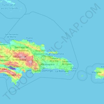
Name: Samaná topographic map, elevation, terrain.
Location: Samaná, Dominican Republic (16.66481 -72.09300 21.86481 -66.89300)
Average elevation: 236 ft
Minimum elevation: -144 ft
Maximum elevation: 9,469 ft
Make a donation
Gear up for your next adventure:
As an Amazon Associate, this site earns from qualifying purchases at no extra cost to you.
Other topographic maps
Click on a map to view its topography, its elevation and its terrain.
Santiago de los Caballeros
Santiago de los Caballeros (Spanish pronunciation: [sanˈtjaɣo ðe los kaβaˈʝeɾos]; English: Saint James of the Knights), often shortened to Santiago, is the second-largest city in the Dominican Republic and the fourth-largest city in the Caribbean by population. It is the capital of Santiago Province and…
Average elevation: 1,119 ft
Río Isabela
Dominican Republic > Santo Domingo > Santo Domingo Norte > Villa Mella
Average elevation: 105 ft
Constanza
The town of Constanza is located at a height of 1220 meters (4000 ft) above sea level in the middle of the Cordillera Central (Central Range), the tallest mountain range in the island of Hispaniola and the entire Caribbean region. The annual average temperatures range from 41 °F (5 °C) to 68 °F (20 °C),…
Average elevation: 4,833 ft
Make a donation
Gear up for your next adventure:
As an Amazon Associate, this site earns from qualifying purchases at no extra cost to you.
Make a donation
Gear up for your next adventure:
As an Amazon Associate, this site earns from qualifying purchases at no extra cost to you.
San Francisco de Macorís
The relief of Duarte Province ranges from 17 to 942 metres (56 to 3,091 ft) above sea level, reaching its highest elevation at "Loma Quita Espuela". This name allegedly comes from the time when the Spaniards were exploring the island, since the hill was too steep to ride their horses, they had to dismount and…
Average elevation: 715 ft
Make a donation
Gear up for your next adventure:
As an Amazon Associate, this site earns from qualifying purchases at no extra cost to you.
Make a donation
Gear up for your next adventure:
As an Amazon Associate, this site earns from qualifying purchases at no extra cost to you.
Make a donation
Gear up for your next adventure:
As an Amazon Associate, this site earns from qualifying purchases at no extra cost to you.