
Saguaro National Park topographic map
Interactive map
Click on the map to display elevation.
About this map
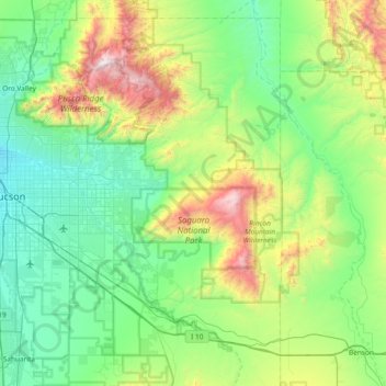
Name: Saguaro National Park topographic map, elevation, terrain.
Location: Saguaro National Park, Pima County, Arizona, United States (32.10403 -111.24383 32.35206 -110.49850)
Average elevation: 3,852 ft
Minimum elevation: 2,293 ft
Maximum elevation: 9,134 ft
Both districts conserve tracts of the Sonoran Desert, including ranges of significant hills, the Tucson Mountains in the west and the Rincon Mountains in the east. Elevations in the Tucson Mountain District range from 2,180 to 4,687 feet (664 to 1,429 m), the summit of Wasson Peak. Elevations within the Rincon Mountain District vary from 2,670 to 8,666 feet (814 to 2,641 m) at the summit of Mica Mountain.
Other topographic maps
Click on a map to view its topography, its elevation and its terrain.
Tucson
United States > Arizona > Pima County
Tucson, Pima County, Arizona, United States
Average elevation: 2,697 ft
Oro Valley
United States > Arizona > Pima County
Oro Valley, Pima County, Arizona, United States
Average elevation: 3,179 ft
Tucson
United States > Arizona > Pima County > Tucson
Tucson, Pima County, Arizona, 85701, United States
Average elevation: 2,743 ft
Vail
United States > Arizona > Pima County > Vail
Vail, Pima County, Arizona, United States
Average elevation: 3,396 ft
Green Valley
United States > Arizona > Pima County > Sahuarita
Green Valley, Sahuarita, Pima County, Arizona, United States
Average elevation: 3,156 ft
Ajo
United States > Arizona > Pima County
Ajo, Pima County, Arizona, 85321, United States
Average elevation: 1,775 ft
Coronado Heights
United States > Arizona > Pima County > Tucson
Coronado Heights, Tucson, Pima County, Arizona, United States
Average elevation: 2,352 ft
Sahuarita
United States > Arizona > Pima County
Sahuarita, Pima County, Arizona, United States
Average elevation: 2,917 ft
Catalina Foothills
United States > Arizona > Pima County > Tucson
Catalina Foothills, Tucson, Pima County, Arizona, United States
Average elevation: 3,114 ft
Green Valley
United States > Arizona > Pima County
Green Valley, Pima County, Arizona, 85614, United States
Average elevation: 2,999 ft
Agua Caliente Wash
United States > Arizona > Pima County > Tucson
Agua Caliente Wash, Powder Horn Ranch, Tucson, Pima County, Arizona, United States
Average elevation: 2,595 ft
Flowing Wells
United States > Arizona > Pima County
Flowing Wells, Jaynes, Pima County, Arizona, United States
Average elevation: 2,254 ft
Drexel Heights
United States > Arizona > Pima County > Tucson
Drexel Heights, Tucson, Pima County, Arizona, United States
Average elevation: 2,579 ft
Tucson Estates
United States > Arizona > Pima County
Tucson Estates, Pima County, Arizona, 85735, United States
Average elevation: 2,579 ft
San Xavier
United States > Arizona > Pima County
San Xavier, Pima County, Arizona, United States
Average elevation: 3,533 ft
Vail
United States > Arizona > Pima County
Vail, Pima County, Arizona, United States
Average elevation: 3,212 ft
Sells
United States > Arizona > Pima County
Sells, Sells District, Pima County, Arizona, 85734, United States
Average elevation: 2,431 ft
Why
United States > Arizona > Pima County
Why, Pima County, Arizona, United States
Average elevation: 1,808 ft
Three Points
United States > Arizona > Pima County
Three Points, San Xavier District, Pima County, Arizona, United States
Average elevation: 2,851 ft
Tortolita
United States > Arizona > Pima County
Tortolita, Pima County, Arizona, 85742, United States
Average elevation: 2,566 ft
Sonoran Desert
United States > Arizona > Pima County
Sonoran Desert, Pima County, Arizona, United States
Average elevation: 1,696 ft
Dos Titos
United States > Arizona > Pima County
Dos Titos, Pima County, Arizona, United States
Average elevation: 2,530 ft
Valencia West
United States > Arizona > Pima County
Valencia West, Pima County, Arizona, United States
Average elevation: 2,490 ft
Mitchell Park
United States > Arizona > Pima County > Tucson
Mitchell Park, Mountain 1st Avenue, Tucson, Pima County, Arizona, United States
Average elevation: 2,398 ft
Marana
United States > Arizona > Pima County
Marana, Pima County, Arizona, United States
Average elevation: 2,156 ft
Twin Buttes
United States > Arizona > Pima County
Twin Buttes, Pima County, Arizona, United States
Average elevation: 3,451 ft
Pusch Ridge
United States > Arizona > Pima County
Pusch Ridge, Pima County, Arizona, 85704, United States
Average elevation: 3,885 ft
Mount Lemmon
United States > Arizona > Pima County
Mount Lemmon, Pima County, Arizona, United States
Average elevation: 8,258 ft
Cerro Colorado Mountains
United States > Arizona > Pima County
Cerro Colorado Mountains, Pima County, Arizona, United States
Average elevation: 4,304 ft
Santa Cruz River
United States > Arizona > Pima County > Marana
Santa Cruz River, Marana, Pima County, Arizona, United States
Average elevation: 1,998 ft
Catalina
United States > Arizona > Pima County
Catalina, Pima County, Arizona, 85739, United States
Average elevation: 3,117 ft
Tanque Verde Falls
United States > Arizona > Pima County
Tanque Verde Falls, Pima County, Arizona, United States
Average elevation: 3,409 ft
Corona de Tucson
United States > Arizona > Pima County
Corona de Tucson, Pima County, Arizona, 85641, United States
Average elevation: 3,412 ft
Mexican Town
United States > Arizona > Pima County > Ajo
Mexican Town, Ajo, Pima County, Arizona, 85321, United States
Average elevation: 1,824 ft
Oro Valley
United States > Arizona > Pima County > Oro Valley
Oro Valley, Pima County, Arizona, 85737, United States
Average elevation: 2,867 ft
Tanque Verde
United States > Arizona > Pima County
Tanque Verde, Pima County, Arizona, 85749, United States
Average elevation: 3,035 ft
Mica Mountain
United States > Arizona > Pima County
Mica Mountain, Pima County, Arizona, United States
Average elevation: 7,936 ft
Iron Horse
United States > Arizona > Pima County > Tucson
Iron Horse, Tucson, Pima County, Arizona, United States
Average elevation: 2,415 ft
Archer Lake
United States > Arizona > Pima County > Tucson
Archer Lake, Tucson, Pima County, Arizona, United States
Average elevation: 2,280 ft
Valencia West
United States > Arizona > Pima County > Valencia West
Valencia West, Pima County, Arizona, United States
Average elevation: 2,490 ft
Rillito River
United States > Arizona > Pima County > Tucson
Rillito River, Tucson, Pima County, Arizona, United States
Average elevation: 2,592 ft
Mount Lemmon
United States > Arizona > Pima County
Mount Lemmon, Pima County, Arizona, 85619, United States
Average elevation: 8,251 ft
Continental
United States > Arizona > Pima County
Continental, Pima County, Arizona, 85614, United States
Average elevation: 2,913 ft
South Mountain
United States > Arizona > Pima County
South Mountain, Sells District, Pima County, Arizona, United States
Average elevation: 2,805 ft
Summerhaven
United States > Arizona > Pima County
Summerhaven, Pima County, Arizona, 85619, United States
Average elevation: 7,605 ft
Garfiled Wash
United States > Arizona > Pima County
Garfiled Wash, Pima County, Arizona, 85704, United States
Average elevation: 2,493 ft
Dobson
United States > Arizona > Pima County
Dobson, Pima County, Arizona, United States
Average elevation: 1,913 ft
Ragged Top
United States > Arizona > Pima County
Ragged Top, Pima County, Arizona, United States
Average elevation: 2,592 ft
Tortolita
United States > Arizona > Pima County > Oro Valley
Tortolita, Oro Valley, Pima County, Arizona, United States
Average elevation: 2,959 ft
South Tucson
United States > Arizona > Pima County
South Tucson, Pima County, Arizona, United States
Average elevation: 2,431 ft