Geolocate

Altare topographic map

Click on the map to display elevation.

About this map

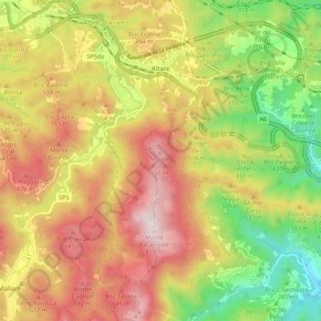
Name: Altare topographic map, elevation, terrain.

Location: Altare, Savona, Liguria, 17041, Italy (44.28433 8.31350 44.34998 8.35841)

Average elevation: 1,437 ft

Minimum elevation: 187 ft

Maximum elevation: 2,667 ft

Other topographic maps

Click on a map to view its topography, its elevation and its terrain.

Vara Superiore

Italy > Liguria > Savona

Average elevation: 2,687 ft

Perru

Italy > Liguria > Savona > Albisola Superiore

Average elevation: 1,207 ft

Montefreddo

Italy > Liguria > Savona > Mallare

Average elevation: 1,726 ft

Praie

Italy > Liguria > Savona > Piana Crixia

Average elevation: 1,125 ft

San Giuseppe di Cairo

Italy > Liguria > Savona > Cairo Montenotte

Average elevation: 1,293 ft

Riofreddo

Italy > Liguria > Savona

Average elevation: 2,677 ft

Santa Giulia

Italy > Liguria > Savona > Dego

Average elevation: 1,804 ft

Armati

Italy > Liguria > Savona > Stellanello

Average elevation: 1,401 ft

Villarelli

Italy > Liguria > Savona > Stellanello

Average elevation: 1,102 ft

Varigotti

Italy > Liguria > Savona > Finale Ligure

Average elevation: 328 ft

Bardino Nuovo

Italy > Liguria > Savona

Average elevation: 935 ft

Costa dei Ginestri

Italy > Liguria > Savona > Bergeggi

Average elevation: 266 ft

Varigotti

Italy > Liguria > Savona > Finale Ligure

Average elevation: 328 ft

Monte Agri

Italy > Liguria > Savona > Savona

Average elevation: 1,037 ft

Gear up for your next adventure:

🔋Solar Power Banks - Keep your GPS and phone charged in remote wilderness areas
🛰️Handheld GPS Units - Professional satellite navigators for precise backcountry mapping
🧥Waterproof Jacket for Hiking - Breathable and rugged rain jacket for outdoor excursions
🎒Waterproof Dry Bags - Keep your electronics and maps dry inside your pack
GPS Sports Watch - GPS watch for running, hiking and training

As an Amazon Associate, this site earns from qualifying purchases at no extra cost to you.