
Cornwall topographic map
Click on the map to display elevation.
Cornwall
The interior of the county consists of a roughly east–west spine of infertile and exposed upland, with a series of granite intrusions, such as Bodmin Moor, which contains the highest land within Cornwall. From east to west, and with approximately descending altitude, these are Bodmin Moor, Hensbarrow north of St Austell, Carnmenellis to the south of Camborne, and the Penwith or Land's End peninsula. These intrusions are the central part of the granite outcrops that form the exposed parts of the Cornubian batholith of south-west Britain, which also includes Dartmoor to the east in Devon and the Isles of Scilly to the west, the latter now being partially submerged.
About this map
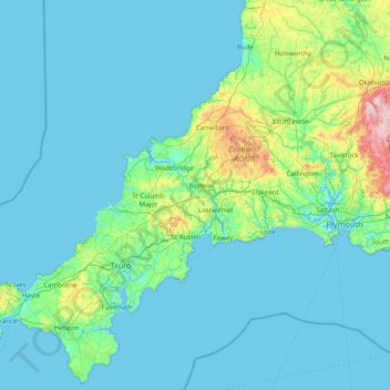
Name: Cornwall topographic map, elevation, terrain.
Location: Cornwall, England, United Kingdom (49.95541 -5.74711 50.93127 -4.16494)
Average elevation: 180 ft
Minimum elevation: 0 ft
Maximum elevation: 2,014 ft
Other topographic maps
Click on a map to view its topography, its elevation and its terrain.
Cambridge
United Kingdom > England > Cambridge
The city, like most of the UK, has a maritime climate highly influenced by the Gulf Stream. Located in the driest region of Britain, Cambridge's rainfall averages around 570 mm (22.44 in) per year, around half the national average, with some years occasionally falling into the semi-arid (under 500 mm (19.69…
Average elevation: 59 ft
Gateshead
United Kingdom > England > Tyne and Wear > Gateshead
One of the most distinguishing features of Gateshead is its topography. The land rises 230 feet (70 m) from Gateshead Quays to the town centre and continues rising to a height of 525 feet (160 m) at Queen Elizabeth Hospital in Sheriff Hill. This is in contrast to the flat and low lying Team Valley located on…
Average elevation: 203 ft
Weston-super-Mare
United Kingdom > England > North Somerset > Weston-super-Mare
Average elevation: 43 ft
Swindon
United Kingdom > England > Swindon
Swindon has an oceanic climate (Cfb in the Köppen climate classification), like the vast majority of the British Isles, with cool winters and warm summers. The nearest official weather station is RAF Lyneham, about 10 miles (16 km) west southwest of Swindon town centre. The weather station's elevation is 145…
Average elevation: 354 ft
Leeds
Lying in the eastern foothills of the Pennines, there is a significant variation in elevation within the city's built-up area. The district ranges from 1,115 feet (340 m) in the far west on the slopes of Ilkley Moor to about 33 feet (10 m) where the rivers Aire and Wharfe cross the eastern boundary. Land rises…
Average elevation: 308 ft
St Albans
United Kingdom > England > Hertfordshire > St Albans
St Albans was an ancient borough created following the dissolution of the monastery in 1539. It consisted of the ancient parish of St Albans (also known as the Abbey parish) and parts of St Michael and St Peter. The municipal corporation was reformed by the Municipal Corporations Act 1835 and the boundary was…
Average elevation: 328 ft
Plymouth
United Kingdom > England > Devon > Plymouth
The River Plym, which flows off Dartmoor to the north-east, forms a smaller estuary to the east of the city called Cattewater. Plymouth Sound is protected from the sea by the Plymouth Breakwater, in use since 1814. In the Sound is Drake's Island which is seen from Plymouth Hoe, a flat public area on top of…
Average elevation: 266 ft
Atherton
There were several ministers of note of Chowbent Chapel including James Wood, the "General" (1672–1759), who distinguished himself at the Battle of Preston in 1715. Thomas Walker Horsfield (1792–1837) was a historian and topographer. Joseph Nightingale (1775–1824), born in Chowbent, was a prolific…
Average elevation: 226 ft
Tutnalls
United Kingdom > England > Gloucestershire > Forest of Dean > Lydney
Average elevation: 102 ft
Watermead Country Park
United Kingdom > England > Leicestershire > Charnwood > Birstall
Average elevation: 194 ft
Boars Hill
United Kingdom > England > Oxfordshire > Vale of White Horse > Wootton
Average elevation: 348 ft
Richmond
United Kingdom > England > London
The town centre lies just below 33 ft (10m) above sea level. South of the town centre, rising from Richmond Bridge to an elevation of 165 ft (50m), is Richmond Hill. Just beyond the summit of Richmond Hill is Richmond Park, an area of 2,360 acres (9.55 km2; 3.7 sq mi) of wild heath and woodland originally…
Average elevation: 56 ft
Stoke-on-Trent
United Kingdom > England > Stoke-on-Trent > Stoke-on-Trent
In 1919, the borough proposed to expand further and annex the neighbouring borough of Newcastle-under-Lyme and the Wolstanton United Urban District, both to the west of Stoke. This never took place, due to strong objections from Newcastle Corporation. A further attempt was made in 1930, with the promotion of…
Average elevation: 525 ft
Peterborough
United Kingdom > England > Cambridgeshire
The local topography is flat, and in some places, the land lies below sea level, for example in parts of the Fens to the east and to the south of Peterborough. Human settlement in the area began before the Bronze Age, as can be seen at the Flag Fen archaeological site to the east of the current city centre,…
Average elevation: 56 ft
Forncett End
United Kingdom > England > Norfolk > South Norfolk > Tacolneston
Average elevation: 174 ft
Putney
Putney Heath is around 400 acres (160 hectares) less the nascent A3 road in size and rises to 45 metres (148 ft) above sea level. Because of its elevation, from 1796 to 1816 Putney Heath hosted a station in the shutter telegraph chain, which connected the Admiralty in London to its naval ships in Portsmouth.…
Average elevation: 59 ft
Bude
United Kingdom > England > Cornwall
Its earlier importance was as a harbour, and then a source of sea sand useful for improving the inland soil. This was transported on the Bude Canal. The Victorians favoured it as a seaside resort. With new rail links, it became a popular seaside destination in the 20th century. Bradshaw's Guide of 1866,…
Average elevation: 135 ft
West Bromwich
United Kingdom > England > Sandwell
The town's football club is West Bromwich Albion. The club was founded in 1878 and in 1888 it became one of the 12 founder members of the Football League. It won the league championship in 1920 and has won the FA Cup five times, most recently in 1968, and won the League Cup in 1966. Albion were based in and…
Average elevation: 489 ft
Salisbury
United Kingdom > England > Salisbury
Bishop of Salisbury Hubert Walter was instrumental in the negotiations with Saladin during the Third Crusade, but he spent little time in his diocese prior to his elevation to archbishop of Canterbury. The brothers Herbert and Richard Poore succeeded him and began planning the relocation of the cathedral into…
Average elevation: 315 ft
Monkton Mead
United Kingdom > England > Hampshire > New Forest > Breamore > South Charford
Average elevation: 171 ft
Albert Village
United Kingdom > England > Leicestershire > North West Leicestershire
Average elevation: 371 ft
Staines-upon-Thames
United Kingdom > England > Surrey > Borough of Spelthorne
Much of the town is built on gravel "islands" that rise above the low-lying floodplains of the Thames and Colne. These gravel deposits have a typical maximum elevation of 14 m (46 ft) above ordnance datum (AOD) and are as little as 0.5 m (1.6 ft) above the surrounding floodplain. Staines High Street, oriented…
Average elevation: 66 ft
Rishton
United Kingdom > England > Lancashire > Hyndburn
Rishton is situated in an area of low moorland north east of Blackburn and north west of Accrington. Its elevation above sea level varies from 250 feet (76 m) in the east, where Norden Brook flows into the River Hyndburn, to 785 feet (239 m) on Rishton Height, north west of the town.
Average elevation: 495 ft
Beeston Castle
United Kingdom > England > Cheshire West and Chester > Beeston
Average elevation: 197 ft