
Hobart topographic map
Click on the map to display elevation.
About this map
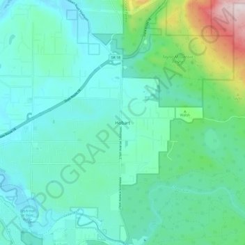
Name: Hobart topographic map, elevation, terrain.
Location: Hobart, King County, Washington, United States (47.37440 -122.01233 47.45440 -121.93233)
Average elevation: 771 ft
Minimum elevation: 348 ft
Maximum elevation: 2,566 ft
King County trails, hiking, mountain biking, running and outdoor activities
Other topographic maps
Click on a map to view its topography, its elevation and its terrain.
Fritz Hedges Waterway Park
United States > Washington > King County > Seattle
Average elevation: 105 ft
Lake Marcel
United States > Washington > King County
Lake Marcel is at an altitude of 295 feet (90 m) above sea level. The lake sits in a bowl at the top of Stillwater Hill on the east side of the Snoqualmie Valley, north of Carnation. It has two main areas of water connected by a channel, and several peninsular features make an extensive shoreline around the…
Average elevation: 361 ft
Mercer Island
United States > Washington > King County > Mercer Island
Mercer Island City Hall is located at 47°34′39″N 122°12′43.2″W / 47.57750°N 122.212000°W / 47.57750; -122.212000 (47.5775, -122.212). The peak elevation in the city is about 338 feet (103 m), near the center of the island.
Average elevation: 128 ft
Snoqualmie River
United States > Washington > King County
The Middle Fork Valley is a popular recreational area since it is accessible during the winter due to its low altitude and close proximity to Seattle. For many years the Middle Fork Road extended 24 miles to Hardscrabble Creek, but was gated at Dingford Creek in June 2007, 18 miles in. The gate at Dingford…
Average elevation: 696 ft
Muckleshoot Tribe Reservation
United States > Washington > King County > Auburn
Average elevation: 535 ft
West Tiger Mountain Natural Resource Conservation Area
United States > Washington > King County > Issaquah
Average elevation: 331 ft
Clyde Hill
United States > Washington > King County
The top elevation is close to 375 feet. There are approximately 21 miles of public roadways in Clyde Hill.
Average elevation: 157 ft
Donnie Chin International Children’s Park
United States > Washington > King County > Seattle
Average elevation: 141 ft