
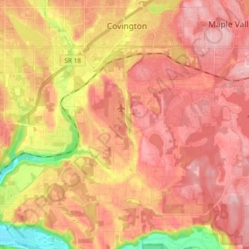
Lake Morton-Berrydale topographic map
Interactive map
Click on the map to display elevation.
About this map
Name: Lake Morton-Berrydale topographic map, elevation, terrain.
Average elevation: 433 ft
Minimum elevation: 69 ft
Maximum elevation: 633 ft
King County trails, hiking, mountain biking, running and outdoor activities
Other topographic maps
Click on a map to view its topography, its elevation and its terrain.
Snoqualmie Pass
United States > Washington > King County
Due to its elevation, Snoqualmie Pass experiences significantly lower temperatures than Seattle, and receives much more precipitation, much of it being snow. Snoqualmie Pass has a humid continental climate (Koppen: Dsb bordering Csb) with cold, very wet and snowy winters, and mild to warm, relatively dry…
Average elevation: 3,438 ft
Mount Si
United States > Washington > King County
The peak can be accessed by two trails. The Old Mount Si trail is accessed by the Little Si parking lot and the Boulder Garden Loop. It is 0.6 miles (0.97 km) shorter, 270 feet (82 m) steeper in elevation gain, and less crowded than the main trail. The Mount Si trail is accessed by the Mount Si parking lot.
Average elevation: 2,582 ft
Fritz Hedges Waterway Park
United States > Washington > King County > Seattle
Average elevation: 105 ft
Mercer Island
United States > Washington > King County > Mercer Island
Mercer Island City Hall is located at 47°34′39″N 122°12′43.2″W / 47.57750°N 122.212000°W / 47.57750; -122.212000 (47.5775, -122.212). The peak elevation in the city is about 338 feet (103 m), near the center of the island.
Average elevation: 128 ft
West Tiger Mountain Natural Resource Conservation Area
United States > Washington > King County > Issaquah
Average elevation: 331 ft
Ravensdale
United States > Washington > King County
Ravensdale is located in southern King County at 47°21′24″N 121°58′39″W / 47.35667°N 121.97750°W / 47.35667; -121.97750. It is bordered to the west by the city of Maple Valley. Ravensdale is 28 miles (45 km) southeast of downtown Seattle and the same distance northeast of Tacoma. It is…
Average elevation: 735 ft
Woodinville
United States > Washington > King County > Woodinville > Woodinville
Average elevation: 262 ft
Donnie Chin International Children’s Park
United States > Washington > King County > Seattle
Average elevation: 141 ft
Cougar Hills
United States > Washington > King County > Bellevue > Cougar Hills
Average elevation: 528 ft
Mint Grove
United States > Washington > King County > Sammamish > Mint Grove
Average elevation: 151 ft
Sheridan Beach
United States > Washington > King County > Lake Forest Park > Sheridan Beach
Average elevation: 200 ft