
Make a donation
Gear up for your next adventure:
As an Amazon Associate, this site earns from qualifying purchases at no extra cost to you.
海溪乡 topographic map
Click on the map to display elevation.
Make a donation
Gear up for your next adventure:
As an Amazon Associate, this site earns from qualifying purchases at no extra cost to you.
About this map
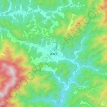
Name: 海溪乡 topographic map, elevation, terrain.
Location: 海溪乡, 丽水市, 浙江省, 中国 (28.35655 120.04940 28.43655 120.12940)
Average elevation: 1,385 ft
Minimum elevation: 269 ft
Maximum elevation: 3,917 ft
Make a donation
Gear up for your next adventure:
As an Amazon Associate, this site earns from qualifying purchases at no extra cost to you.
Other topographic maps
Click on a map to view its topography, its elevation and its terrain.
青田县
青田属亚热带季风气候夏季高温多雨,冬季温和少雨,温暖湿润,四季分明,因地形复杂,海拔高度悬殊,气候存在着垂直带。据县气象站1971-1987年观察统计,县城平均气温18.3℃,是全省年平均最高的地区之一。县内100米以下的河谷低丘地区,年平均气温18℃;200-300米的丘陵地区,年平均气温17℃左右;400-600米的丘陵低山区年平均气温15-16℃;800米以上的山区,年平均气温14℃以下。海拔每升高100米,年平均气温降低0.59℃。青田县年平均无霜期为279天,平均初霜期为11月30日,终霜日期为2月23日。
Average elevation: 1,555 ft
Make a donation
Gear up for your next adventure:
As an Amazon Associate, this site earns from qualifying purchases at no extra cost to you.