
Melhus topographic map
Interactive map
Click on the map to display elevation.
About this map
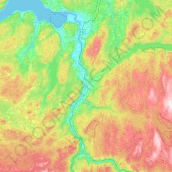
Name: Melhus topographic map, elevation, terrain.
Location: Melhus, Tröndelag, Norwegen (63.01969 9.87841 63.34463 10.71616)
Average elevation: 1,112 ft
Minimum elevation: 0 ft
Maximum elevation: 3,077 ft
Other topographic maps
Click on a map to view its topography, its elevation and its terrain.
Brettingen fort
Norwegen > Tröndelag > Fevågaunet
Brettingen fort, Brettingsveien, Fevågaunet, Indre Fosen, Tröndelag, 7112, Norwegen
Average elevation: 98 ft
Kyrksæterøra
Kyrksæterøra, Heim, Tröndelag, 7200, Norwegen
Average elevation: 341 ft
Utvorden fort Sør
Norwegen > Tröndelag > Utvorda
Utvorden fort Sør, Utvordveien, Utvorda, Flatanger, Tröndelag, Norwegen
Average elevation: 131 ft