Geolocate

Lisio topographic map

Click on the map to display elevation.

About this map

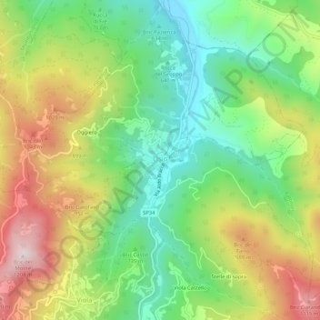
Name: Lisio topographic map, elevation, terrain.

Location: Lisio, Cuneo, Piedmont, Italy (44.28693 7.95667 44.32467 8.00356)

Average elevation: 2,612 ft

Minimum elevation: 1,709 ft

Maximum elevation: 3,871 ft

Other topographic maps

Click on a map to view its topography, its elevation and its terrain.

Maschere

Italy > Piedmont > Cuneo > Saluzzo

Average elevation: 1,270 ft

Borgo San Giuseppe

Italy > Piedmont > Cuneo > Cuneo

Average elevation: 1,706 ft

Beltramone

Italy > Piedmont > Cuneo > Barge

Average elevation: 2,014 ft

Nitte

Italy > Piedmont > Cuneo > Verzuolo

Average elevation: 1,240 ft

Colle Fauniera

Italy > Piedmont > Cuneo > Demonte

The Colle Fauniera is a mountain pass in the Cottian Alps, Piedmont, northern Italy, located at 2,480+ m elevation.

Average elevation: 7,595 ft

Monte Pennino

Italy > Piedmont > Cuneo > Garessio

Average elevation: 3,504 ft

Madonna della Neve

Italy > Piedmont > Cuneo > Clavesana

Average elevation: 1,079 ft

Le Balme

Italy > Piedmont > Cuneo > Barge

Average elevation: 2,073 ft

Cascina Dentis

Italy > Piedmont > Cuneo > Savigliano > Levaldigi

Average elevation: 1,234 ft

Pellerina

Italy > Piedmont > Cuneo > Chiusa di Pesio

Average elevation: 5,554 ft

Duranda

Italy > Piedmont > Cuneo > Brossasco

Average elevation: 3,045 ft

Prato Nevoso

Italy > Piedmont > Cuneo

Average elevation: 4,711 ft

Monte Brancetta

Italy > Piedmont > Cuneo > Argentera

Average elevation: 8,094 ft

Bric del Solio

Italy > Piedmont > Cuneo > San Michele Mondovì

Average elevation: 2,119 ft

Pratolungo

Italy > Piedmont > Cuneo > Pratolungo

Average elevation: 4,275 ft

Sorgente del Po

Italy > Piedmont > Cuneo > Crissolo > Pian del Re

Average elevation: 7,592 ft

Castelletto

Italy > Piedmont > Cuneo

Average elevation: 2,687 ft

F.ne Scaglione

Italy > Piedmont > Cuneo > Santo Stefano Belbo > F.ne Scaglione

Average elevation: 1,083 ft

Vasco

Italy > Piedmont > Cuneo > Monastero di Vasco

Average elevation: 1,788 ft

Chiapale

Italy > Piedmont > Cuneo > Valgrana

Average elevation: 3,547 ft

Gear up for your next adventure:

🏫Relief Map Kits - Hands-on tools for teaching landforms and elevation
Solar GPS Watches - Advanced multisport watches with built-in topographic maps
📱Solar Portable Charger - Solar power bank for charging devices off‑grid
🧭Hiking Compass - Precision compass for reliable navigation in the wilderness
🎁Geography Themed Gifts - Unique gift ideas for map lovers and geography enthusiasts

As an Amazon Associate, this site earns from qualifying purchases at no extra cost to you.