
Make a donation
Gear up for your next adventure:
As an Amazon Associate, this site earns from qualifying purchases at no extra cost to you.
Hurley topographic map
Click on the map to display elevation.
Make a donation
Gear up for your next adventure:
As an Amazon Associate, this site earns from qualifying purchases at no extra cost to you.
About this map
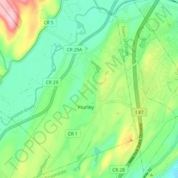
Name: Hurley topographic map, elevation, terrain.
Average elevation: 262 ft
Minimum elevation: 59 ft
Maximum elevation: 699 ft
Ulster County trails, hiking, mountain biking, running and outdoor activities
Make a donation
Gear up for your next adventure:
As an Amazon Associate, this site earns from qualifying purchases at no extra cost to you.
Other topographic maps
Click on a map to view its topography, its elevation and its terrain.
Glenbrook Park
United States > New York > Ulster County > Town of Shandaken
Average elevation: 1,499 ft
Mohonk Mountain House Property
United States > New York > Ulster County > Town of New Paltz
Average elevation: 748 ft
Make a donation
Gear up for your next adventure:
As an Amazon Associate, this site earns from qualifying purchases at no extra cost to you.
Mount Marion Park
United States > New York > Ulster County > Town of Saugerties
Average elevation: 246 ft
Make a donation
Gear up for your next adventure:
As an Amazon Associate, this site earns from qualifying purchases at no extra cost to you.
Connelly
United States > New York > Ulster County > Town of Esopus > Port Ewen
Average elevation: 144 ft
Overlook Mountain
United States > New York > Ulster County > Town of Woodstock
Average elevation: 2,169 ft
Make a donation
Gear up for your next adventure:
As an Amazon Associate, this site earns from qualifying purchases at no extra cost to you.
Sojourner Truth State Park
United States > New York > Ulster County > City of Kingston > East Kingston
Average elevation: 125 ft
Make a donation
Gear up for your next adventure:
As an Amazon Associate, this site earns from qualifying purchases at no extra cost to you.
Frost Valley
United States > New York > Ulster County > Town of Denning > Frost Valley
Average elevation: 2,411 ft
Make a donation
Gear up for your next adventure:
As an Amazon Associate, this site earns from qualifying purchases at no extra cost to you.
Big Indian Park
United States > New York > Ulster County > Town of Shandaken > Big Indian
Average elevation: 1,617 ft
Make a donation
Gear up for your next adventure:
As an Amazon Associate, this site earns from qualifying purchases at no extra cost to you.
Bear Hill Preserve (Cragsmoor Free Library)
United States > New York > Ulster County > Town of Wawarsing > Cragsmoor
Average elevation: 1,358 ft
Sam's Point Overlook
United States > New York > Ulster County > Town of Wawarsing > Village of Ellenville
Average elevation: 1,778 ft
West Saugerties
United States > New York > Ulster County > Town of Saugerties
Average elevation: 817 ft
Make a donation
Gear up for your next adventure:
As an Amazon Associate, this site earns from qualifying purchases at no extra cost to you.
Make a donation
Gear up for your next adventure:
As an Amazon Associate, this site earns from qualifying purchases at no extra cost to you.
Red Hill Fire Tower
United States > New York > Ulster County > Town of Denning
The cabin is a small, one-story, 14-by-24-foot (4.3 by 7.3 m) gable-roofed frame building. It is sided with "brainstorm", edge board stained reddish brown. It has a mortared rubblestone foundation and a covered porch on the south elevation, originally decked in wood but since replaced with concrete. Built in…
Average elevation: 2,339 ft
Greenfield Park
United States > New York > Ulster County > Town of Wawarsing
Average elevation: 1,086 ft