
Make a donation
Gear up for your next adventure:
As an Amazon Associate, this site earns from qualifying purchases at no extra cost to you.
Oodweyne District topographic map
Click on the map to display elevation.
Make a donation
Gear up for your next adventure:
As an Amazon Associate, this site earns from qualifying purchases at no extra cost to you.
About this map
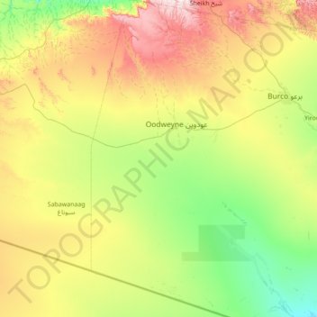
Name: Oodweyne District topographic map, elevation, terrain.
Location: Oodweyne District, Togdheer, Somalia (8.57202 44.69000 9.94019 45.29000)
Average elevation: 3,579 ft
Minimum elevation: 2,516 ft
Maximum elevation: 6,234 ft
Make a donation
Gear up for your next adventure:
As an Amazon Associate, this site earns from qualifying purchases at no extra cost to you.
Other topographic maps
Click on a map to view its topography, its elevation and its terrain.
Burao
Somalia > Togdheer > Burao District
Weather in Burao, much like other inland towns in Somaliland, is very warm to hot and dry year-round. The city has a hot arid climate (Köppen BWh) in common with most of Somalia, although Burao's weather is moderated by altitude. The average daytime temperatures during the summer months of June and August can…
Average elevation: 3,448 ft
Make a donation
Gear up for your next adventure:
As an Amazon Associate, this site earns from qualifying purchases at no extra cost to you.