
Benenden topographic map
Click on the map to display elevation.
About this map
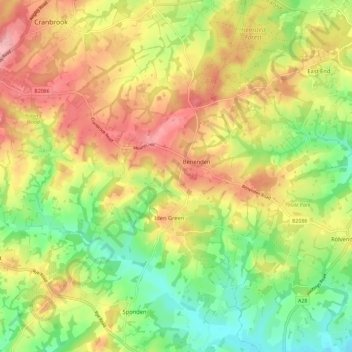
Name: Benenden topographic map, elevation, terrain.
Location: Benenden, Tunbridge Wells, Kent, England, United Kingdom (51.03761 0.53072 51.09144 0.64664)
Average elevation: 200 ft
Minimum elevation: 0 ft
Maximum elevation: 410 ft
Other topographic maps
Click on a map to view its topography, its elevation and its terrain.
Sandhurst Cross
United Kingdom > England > Kent > Tunbridge Wells > Sandhurst
Average elevation: 112 ft
Underground reservoir
United Kingdom > England > Kent > Tunbridge Wells > Hartley > Flishinghurst
Average elevation: 338 ft
Chalybeate Spring
United Kingdom > England > Kent > Tunbridge Wells > Kilndown
Average elevation: 213 ft
Rusthall Common Cricket Ground
United Kingdom > England > Kent > Tunbridge Wells > Rusthall
Average elevation: 325 ft
Bedgebury National Pinetum
United Kingdom > England > Kent > Tunbridge Wells > Kilndown
Average elevation: 299 ft