Make a donation
Gear up for your next adventure:
As an Amazon Associate, this site earns from qualifying purchases at no extra cost to you.
Kangra topographic map
Click on the map to display elevation.
Make a donation
Gear up for your next adventure:
As an Amazon Associate, this site earns from qualifying purchases at no extra cost to you.
About this map
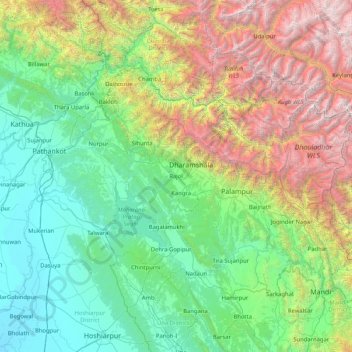
Name: Kangra topographic map, elevation, terrain.
Location: Kangra, Himachal Pradesh, 176217, India (31.46667 75.55000 32.86667 76.95000)
Average elevation: 5,463 ft
Minimum elevation: 738 ft
Maximum elevation: 20,289 ft
Make a donation
Gear up for your next adventure:
As an Amazon Associate, this site earns from qualifying purchases at no extra cost to you.
Other topographic maps
Click on a map to view its topography, its elevation and its terrain.
Make a donation
Gear up for your next adventure:
As an Amazon Associate, this site earns from qualifying purchases at no extra cost to you.
Make a donation
Gear up for your next adventure:
As an Amazon Associate, this site earns from qualifying purchases at no extra cost to you.
Bilaspur
The district lies in the outer foothills of the Himalayas, at the point where they meet the Punjab plains. There are no major mountains in the district, and the overall elevation isn't especially high, but the terrain is very hilly. Flat land is restricted to narrow areas along rivers and streams. The main…
Average elevation: 3,018 ft
Make a donation
Gear up for your next adventure:
As an Amazon Associate, this site earns from qualifying purchases at no extra cost to you.
Make a donation
Gear up for your next adventure:
As an Amazon Associate, this site earns from qualifying purchases at no extra cost to you.
