Geolocate

Chamba topographic map

Click on the map to display elevation.

About this map

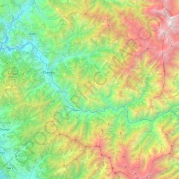
Name: Chamba topographic map, elevation, terrain.

Location: Chamba, Himachal Pradesh, India (32.32388 75.99406 32.71361 76.42590)

Average elevation: 7,743 ft

Minimum elevation: 2,300 ft

Maximum elevation: 18,330 ft

Other topographic maps

Click on a map to view its topography, its elevation and its terrain.

Bachut

India > Himachal Pradesh > Banjar

Average elevation: 8,268 ft

Kotli

India > Himachal Pradesh > Kotli

Kotli Tungal (Kotli) is a small town in Himachal Pradesh, in northern India located along national highway 70 (updated 003) which connects Jalandhar (in Punjab) to Mandi. It is 22 km (14 mi) from the town of Mandi, Kotli is a Sub Division and Tehsil (Sub District) of Mandi District. Kotli and the surrounding…

Average elevation: 3,917 ft

Chachiot

India > Himachal Pradesh > Chachyot

Average elevation: 4,764 ft

Renuka Ji

India > Himachal Pradesh > Renuka

Average elevation: 2,667 ft

Kangra

India > Himachal Pradesh

Average elevation: 5,463 ft

Nagrota Nahan

India > Himachal Pradesh > Rakkar

Average elevation: 1,680 ft

Manikaran

India > Himachal Pradesh > Bhuntar

Average elevation: 8,665 ft

Singhapur

India > Himachal Pradesh > Kumharsain > Rawali

Average elevation: 3,940 ft

jakhu park

India > Himachal Pradesh > Shimla > Sniwoan

Average elevation: 6,893 ft

Tutikandi

India > Himachal Pradesh > Shimla

Average elevation: 5,912 ft

Kunihar

India > Himachal Pradesh > Arki

Average elevation: 3,136 ft

Barog

India > Himachal Pradesh > Nankhari > Nankhari

Average elevation: 6,768 ft

Shangarh

India > Himachal Pradesh > Sainj

Average elevation: 6,926 ft

Shast

India > Himachal Pradesh > Kotkhai

Average elevation: 7,516 ft

Deotsidh

India > Himachal Pradesh > Dhatwal

Average elevation: 2,365 ft

Naggar

India > Himachal Pradesh > Kullu

Average elevation: 6,699 ft

Gattu

India > Himachal Pradesh > Thunag

Average elevation: 6,785 ft

Dharamkot

India > Himachal Pradesh > Dharamshala

Average elevation: 6,227 ft

Narkanda

India > Himachal Pradesh > Kumharsain

Average elevation: 8,091 ft

Rewalsar

India > Himachal Pradesh > Mandi

Rewalsar is located at an altitude of 1360 m above sea level. It is connected to Mandi by a motorable road and is about 25 km from Mandi. Lying in the Southern Himalayan belt, winters in Rewalsar can be freezing, while summers are generally pleasant.

Average elevation: 4,209 ft

Kaza

India > Himachal Pradesh > Spiti

Kaza, also spelled Kaze, Karze, Karzey, is a town and the subdivisional headquarters of the remote Spiti Valley in the western Himalayas in the Lahaul and Spiti district of the northern Indian state of Himachal Pradesh. Spiti is a high altitude or cold desert having close similarities to the neighbouring Tibet…

Average elevation: 13,652 ft

Chitkul

India > Himachal Pradesh > Sangla

Average elevation: 12,123 ft

Jutogh

India > Himachal Pradesh > Shimla (urban)

Jutogh is located at 31°06′N 77°07′E / 31.1°N 77.12°E / 31.1; 77.12 near Totu, an important suburb of Shimla city. It has an average elevation of 1729 metres (5673 feet), a total green area of 112.62 Acres, and a public garden known as Cantt. Board Public Garden.

Average elevation: 5,856 ft

Chakar

India > Himachal Pradesh > Shimla (urban)

Average elevation: 5,892 ft

Qasba

India > Himachal Pradesh > Palampur

Average elevation: 2,631 ft

Namgial

India > Himachal Pradesh > Poo district

Average elevation: 10,397 ft

junu

India > Himachal Pradesh > Chaurah > Teesa

Average elevation: 6,263 ft

Bharari

India > Himachal Pradesh > Shimla (urban)

Average elevation: 6,106 ft

Sairi

India > Himachal Pradesh > Kandaghat

Average elevation: 4,327 ft

Shohola

India > Himachal Pradesh > Ani

Average elevation: 7,946 ft

Andhra

India > Himachal Pradesh > Chirgaon > Dagoli

Average elevation: 7,657 ft

Yamling

India > Himachal Pradesh > Lahul

Average elevation: 11,220 ft

ail

India > Himachal Pradesh > Chaurah

Average elevation: 6,864 ft

Sainj

India > Himachal Pradesh > Theog

Average elevation: 5,000 ft

Baragaon

India > Himachal Pradesh > Kumharsain

Average elevation: 4,186 ft

Sadona

India > Himachal Pradesh > Chaupal

Average elevation: 7,123 ft

Phabrang

India > Himachal Pradesh > Udaipur

Average elevation: 17,533 ft

Kuthar

India > Himachal Pradesh > Theog

Average elevation: 5,151 ft

Jaglot

India > Himachal Pradesh > Karsog

Average elevation: 5,443 ft

Dalash

India > Himachal Pradesh > Ani > Dalash

Average elevation: 5,912 ft

Burah

India > Himachal Pradesh > Bali Chowki > Balichowki

Average elevation: 5,020 ft

olana

India > Himachal Pradesh > nohra ghat > olana

Average elevation: 6,562 ft

Batal

India > Himachal Pradesh > Arki

Average elevation: 3,681 ft

Parera

India > Himachal Pradesh > Parera

Average elevation: 6,506 ft

Tosa

India > Himachal Pradesh > Chamba

Average elevation: 5,492 ft

Parvati Parbat

India > Himachal Pradesh

Average elevation: 19,075 ft

Maryand

India > Himachal Pradesh > Banjar > Maryand

Average elevation: 8,963 ft

Chilli

India > Himachal Pradesh > Chaurah

Average elevation: 5,105 ft

Nahin

India > Himachal Pradesh > Chamba

Average elevation: 3,399 ft

Goj

India > Himachal Pradesh > Kullu > Manikaran

Average elevation: 7,139 ft

suila

India > Himachal Pradesh > Chaurah > suila

Average elevation: 7,785 ft

Sarchu

India > Himachal Pradesh > Lahul

Average elevation: 17,743 ft

Baralacha Pass

India > Himachal Pradesh > Lahul

"The Bara Lacha is the boundary between two separate regions distinguished by their physical characteristics. That which we have already passed through may be called the true Himalayan region. Here the gigantic ranges are covered with perpetual snow, furrowed by glaciers, and they arise from amid dense forests…

Average elevation: 16,348 ft

Keylang

India > Himachal Pradesh > Lahul > Keylang

Average elevation: 12,556 ft

Sarahan

India > Himachal Pradesh > Nermand > Sarahan

Average elevation: 8,468 ft

Surah

India > Himachal Pradesh > Chachyot > Surah

Average elevation: 4,055 ft

Tharli

India > Himachal Pradesh > Karsog > Tharli

Average elevation: 5,837 ft

Rohtang Pass

India > Himachal Pradesh > Lahul

Average elevation: 13,261 ft

Brahman Koti

India > Himachal Pradesh > Kullu > Naggar

Average elevation: 5,820 ft

Kasha

India > Himachal Pradesh > Rampur

Average elevation: 8,999 ft

Sarah

India > Himachal Pradesh > Dharamshala

Average elevation: 2,953 ft

meas

India > Himachal Pradesh > Chaurah

Average elevation: 8,465 ft

Triund

India > Himachal Pradesh > Saluni

Average elevation: 6,312 ft

Tawain

India > Himachal Pradesh > Pangi

Average elevation: 10,348 ft

Badain

India > Himachal Pradesh > Rampur > Tikar

Average elevation: 8,474 ft

Krishangarh

India > Himachal Pradesh > Krishangarh

Average elevation: 3,629 ft

Gear up for your next adventure:

🎒Gear Packing Cubes - Organize your backpack efficiently
🎒Waterproof Dry Bags - Keep your electronics and maps dry inside your pack
🛌Ultralight Sleeping Bags - Compact down bags for cold nights in the wilderness
📷Action Camera - Capture your outdoor adventures in HD
📡GPS Antenna Upgrade - Enhance GPS reception in remote terrain

As an Amazon Associate, this site earns from qualifying purchases at no extra cost to you.