Geolocate

Tundla topographic map

Click on the map to display elevation.

About this map

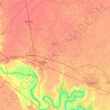
Name: Tundla topographic map, elevation, terrain.

Location: Tundla, Agra division, Uttar Pradesh, 283204, India (27.07355 78.19415 27.39551 78.38754)

Average elevation: 541 ft

Minimum elevation: 436 ft

Maximum elevation: 574 ft

Other topographic maps

Click on a map to view its topography, its elevation and its terrain.

Sravasti

India > Uttar Pradesh > Ikauna

Average elevation: 371 ft

Firojpur

India > Uttar Pradesh > Moradabad

Average elevation: 692 ft

Ralpur Khadar

India > Uttar Pradesh > Noida > Dadri

Average elevation: 653 ft

Lal Kuan

India > Uttar Pradesh > Ghaziabad

Average elevation: 692 ft

Chinhat

India > Uttar Pradesh > Lucknow

Average elevation: 384 ft

Dewal

India > Uttar Pradesh > Zamania

Average elevation: 217 ft

Faizabad

India > Uttar Pradesh

Average elevation: 331 ft

Lalitpur

India > Uttar Pradesh

Average elevation: 1,299 ft

Barawa Shukdev

India > Uttar Pradesh > Kasya

Average elevation: 256 ft

Noida

India > Uttar Pradesh > Dadri

Average elevation: 709 ft

Meerut

India > Uttar Pradesh

Average elevation: 738 ft

Raebareli

India > Uttar Pradesh > Raebareli

The district forms a part of the Gangetic plain which is of recent origin according to geological chronology and reveal ordinary Gangetic alluvium. The district being a part of the alluvial plain conforms to the same geological sequence as the plain itself. The only mineral of importance is kankar. The…

Average elevation: 364 ft

Kamalganj

India > Uttar Pradesh > Farrukhabad

Average elevation: 472 ft

Govardhan

India > Uttar Pradesh > Mathura

Govardhana is located at 27°30′N 77°28′E / 27.5°N 77.47°E / 27.5; 77.47. It has an average elevation of 179 metres (587 feet). Govardhana has been made Tehsil in Mathura District by the Uttar Pradesh government.

Average elevation: 594 ft

Naini

India > Uttar Pradesh > Karchhana

Average elevation: 292 ft

Khudaganj

India > Uttar Pradesh > Tilhar

Average elevation: 531 ft

Shafipur

India > Uttar Pradesh > Shafipur

Average elevation: 643 ft

Dalla

India > Uttar Pradesh > Robertsganj > Dalla

Average elevation: 705 ft

Miranpur Katra

India > Uttar Pradesh > Tilhar > Miranpur Katra

Average elevation: 522 ft

Nigohi

India > Uttar Pradesh > Tilhar > Nigohi

Average elevation: 525 ft

vegetation

India > Uttar Pradesh > Sirathu

Average elevation: 338 ft

Sahaspur

India > Uttar Pradesh > Dhampur

Sahaspur is located at 29°07′16″N 78°37′16″E / 29.121°N 78.621°E / 29.121; 78.621. It has an average elevation of 199 metres (653 feet).

Average elevation: 712 ft

Chauhan Patti

India > Uttar Pradesh > Kushinagar

Average elevation: 256 ft

Gear up for your next adventure:

🦶Hiking Gaiters - Keep debris and water out of your boots
🗺️NatGeo Topo Maps - High-quality waterproof printed topographic maps of US Parks
📡Handheld GPS Device - Reliable handheld GPS for outdoor navigation
🔥Fast-Boil Camping Stoves - Efficient cooking systems for quick trail meals
🏕️Tent Footprint - Protect your tent base from wear

As an Amazon Associate, this site earns from qualifying purchases at no extra cost to you.