
Lago Vista topographic map
Click on the map to display elevation.
Lago Vista
Lago Vista is situated on the northern shore of Lake Travis within the Texas Hill Country. The area's terrain is notably rugged, with steep limestone hills and canyons. Elevations range from about 774 feet near the lake to 1,220 feet near Rusty Allen Airport, making it one of the highest points in Travis County. This topography is shaped by its position within the Balcones Canyonlands, contributing to its varied landscape of sharp inclines and scenic vistas. The surrounding natural environment includes both rolling hills and steep cliffs that characterize the region.
About this map
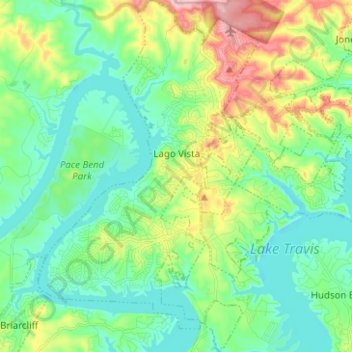
Name: Lago Vista topographic map, elevation, terrain.
Location: Lago Vista, Travis County, Texas, United States (30.39919 -98.03744 30.50717 -97.95484)
Average elevation: 823 ft
Minimum elevation: 643 ft
Maximum elevation: 1,273 ft
Travis County trails, hiking, mountain biking, running and outdoor activities
Other topographic maps
Click on a map to view its topography, its elevation and its terrain.
Roy G. Guerrero Colorado River Metro Park
United States > Texas > Travis County > Austin
Average elevation: 463 ft
Austin
United States > Texas > Travis County > Austin
The elevation of Austin varies from 425 feet (130 m) to approximately 1,000 feet (305 m) above sea level. Due to the fact it straddles the Balcones Fault, much of the eastern part of the city is flat, with heavy clay and loam soils, whereas the western part and western suburbs consist of rolling hills on the…
Average elevation: 666 ft
Pflugerville
United States > Texas > Travis County > Pflugerville > Pflugerville
Average elevation: 719 ft