
Aïr Mountains topographic map
Interactive map
Click on the map to display elevation.
About this map
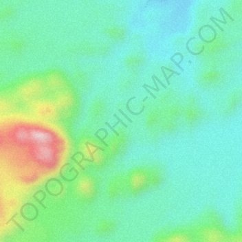
Name: Aïr Mountains topographic map, elevation, terrain.
Location: Aïr Mountains, Tchirozérine, Agadez, Niger (17.84995 8.74995 17.85005 8.75005)
Average elevation: 5,679 ft
Minimum elevation: 5,397 ft
Maximum elevation: 6,371 ft
Other topographic maps
Click on a map to view its topography, its elevation and its terrain.
Daissa Manga
Niger > Diffa Region > Diffa
Daissa Manga, Diffa, Diffa Region, Niger
Average elevation: 1,017 ft
Angoua Kouatche
Angoua Kouatche, Dogondoutchi, Dosso Region, Niger
Average elevation: 814 ft
Angoua Kouatche
Angoua Kouatche, Dogondoutchi, Dosso, 03318097, Niger
Average elevation: 814 ft