
Tenere topographic map
Interactive map
Click on the map to display elevation.
About this map
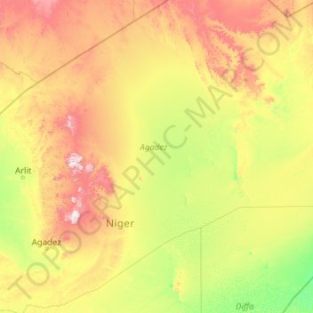
Name: Tenere topographic map, elevation, terrain.
Location: Tenere, Arlit, Agadez, Niger (16.11871 8.60421 22.28252 16.69510)
Average elevation: 1,801 ft
Minimum elevation: 997 ft
Maximum elevation: 6,050 ft
Other topographic maps
Click on a map to view its topography, its elevation and its terrain.
Daissa Manga
Niger > Diffa Region > Diffa
Daissa Manga, Diffa, Diffa Region, Niger
Average elevation: 1,017 ft
Angoua Kouatche
Angoua Kouatche, Dogondoutchi, Dosso Region, Niger
Average elevation: 814 ft
Angoua Kouatche
Angoua Kouatche, Dogondoutchi, Dosso, 03318097, Niger
Average elevation: 814 ft