
London topographic map
Click on the map to display elevation.
London
London has a humid continental climate (Köppen Dfb), though due to its downwind location relative to Lake Huron and elevation changes across the city, it is virtually on the Dfa/Dfb (hot summer) boundary favouring the former climate zone to the southwest of the confluence of the South and North Thames Rivers, and the latter zone to the northeast (including the airport). Because of its location in the continent, London experiences large seasonal contrast, tempered to a point by the surrounding Great Lakes. The summers are usually warm to hot and humid, with a July average of 20.8 °C (69.4 °F), and temperatures above 30 °C (86 °F) occur on average 10 days per year. In 2016, however, temperatures at or above 30 °C (86 °F) occurred more than 35 times, and in 2018, four heatwave incidents led to humidex temperatures topping out at 46 °C (115 °F) . The city is affected by frequent thunderstorms due to hot, humid summer weather, as well as the convergence of breezes originating from Lake Huron and Lake Erie. The same convergence zone is responsible for spawning funnel clouds and the occasional tornado. Spring and autumn in between are not long, and winters are cold but witness frequent thaws. Annual precipitation averages 1,011.5 mm (39.82 in). Its winter snowfall totals are heavy, averaging about 194 cm (76 in) per year, although the localized nature of snow squalls means the total can vary widely from year to year. Some of the snow accumulation comes from lake effect snow and snow squalls originating from Lake Huron, some 60 km (37 mi) to the northwest, which occurs when strong, cold winds blow from that direction. From 5 December 2010, to 9 December 2010, London experienced record snowfall when up to 2 m (79 in) of snow fell in parts of the city. Schools and businesses were closed for three days and bus service was cancelled after the second day of snow.
About this map
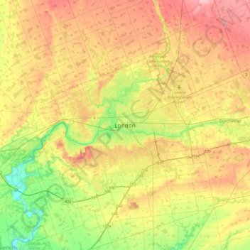
Name: London topographic map, elevation, terrain.
Location: London, Ontario, N6A 3N7, Canada (42.82324 -81.40337 43.14324 -81.08337)
Average elevation: 883 ft
Minimum elevation: 666 ft
Maximum elevation: 1,115 ft
Other topographic maps
Click on a map to view its topography, its elevation and its terrain.
Lake Ontario
Lake Ontario is the easternmost of the Great Lakes and the smallest in surface area (7,340 sq mi, 18,960 km2), although it exceeds Lake Erie in volume (393 cu mi, 1,639 km3). It is the 13th largest lake in the world. When its islands are included, the lake's shoreline is 712 miles (1,146 km) long. As the last…
Average elevation: 702 ft
Lac Seul
Canada > Ontario > Kenora District
Lac Seul is a large, crescent shaped reservoir in Kenora District, northwestern Ontario, Canada. It is approximately 241 km (150 mi) long. It has a maximum (regulated) depth of 47.2 m, with a surface elevation of 357 m above sea level. Its level is raised in the summer and then drawn down in the winter months…
Average elevation: 1,273 ft
Granitehill Lake
Canada > Ontario > Algoma District > Unorganized North Algoma
Average elevation: 1,247 ft
Calm Lake
Canada > Ontario > Rainy River District > Unorganized Rainy River
Average elevation: 1,283 ft
Lauzon Lake
Canada > Ontario > Algoma District > The North Shore Township > Algoma Mills
Average elevation: 689 ft
Niagara River
The river, which is occasionally described as a strait, is about 58 kilometres (36 mi) long and includes Niagara Falls in its course. The falls have moved approximately 11 kilometres (6.8 mi) upstream from the Niagara Escarpment in the last 12,000 years, resulting in a gorge below the falls. Today, the…
Average elevation: 581 ft
Negeek Lake
Canada > Ontario > Renfrew County > Madawaska Valley > Combermere
Average elevation: 1,004 ft
Gibi Lake
Canada > Ontario > Kenora District > Sioux Narrows-Nestor Falls Township
Average elevation: 1,224 ft
Lower Beverley Lake
Canada > Ontario > Leeds and Grenville Counties > Rideau Lakes > Delta
Average elevation: 371 ft
Echo Lake
Canada > Ontario > Timiskaming District > Unorganized West Timiskaming
Average elevation: 1,112 ft
Kipawa Lake
Canada > Ontario > Sudbury District > Unorganized North Sudbury
Average elevation: 1,512 ft
St. Catharines
Canada > Ontario > Niagara Region
The most defining transportation icon of St. Catharines is the Welland Canal, a ship canal that runs 43.4 kilometres (27.0 mi), passing through the city. Four of its locks are within city boundaries. The canal allows shipping vessels to traverse the 99.5-metre (326.5 ft) drop in altitude from Lake Erie to Lake…
Average elevation: 338 ft
Kapuskasing
Canada > Ontario > Cochrane District
Kapuskasing lies in the heart of the Great Clay Belt. The topography of the region is very flat, dotted with numerous small lakes and muskeg bogs. Also in the heart of Canada's boreal forest, the region is drained by rivers running north to James Bay. The district is heavily forested, mostly by thick stands of…
Average elevation: 745 ft
Thousand Islands National Park
Canada > Ontario > Prince Edward County > Frontenac Islands
Average elevation: 354 ft
Golden Lake
Canada > Ontario > Renfrew County > North Algona Wilberforce > Golden Lake
Average elevation: 640 ft
Bala Park Island
Canada > Ontario > Muskoka District > Muskoka Lakes Township > Bala
Average elevation: 748 ft
Nungesser Lake
Canada > Ontario > Kenora District > Unorganized Kenora District
Average elevation: 1,352 ft
Opeongo Lake Dam
Canada > Ontario > Nipissing District > Unorganized South Nipissing
Average elevation: 1,375 ft
Kellow Lake
Canada > Ontario > Thunder Bay District > Unorganized Thunder Bay District
Average elevation: 965 ft
Slate Islands
Canada > Ontario > Kenora District > Unorganized Kenora District
Average elevation: 1,056 ft
Loveland Lake
Canada > Ontario > Kenora District > Unorganized Kenora District
Average elevation: 1,398 ft
Ellery Lake
Canada > Ontario > Cochrane District > Unorganized North Cochrane
Average elevation: 1,148 ft
Obakamiga River;Redfin Lake
Canada > Ontario > Algoma District > Unorganized North Algoma
Average elevation: 1,125 ft
Stewart Lake
Canada > Ontario > Muskoka District > Georgian Bay Township > MacTier
Average elevation: 791 ft
Portal Lake
Canada > Ontario > Sudbury District > Unorganized North Sudbury
Average elevation: 1,460 ft
Hubbard Creek
Canada > Ontario > Sudbury District > Unorganized North Sudbury
Average elevation: 1,499 ft
Sesekinika Lake
Canada > Ontario > Timiskaming District > Unorganized West Timiskaming
Average elevation: 1,047 ft
Galbraith Lake
Canada > Ontario > Kenora District > Unorganized Kenora District
Average elevation: 1,493 ft
Craigleith Provincial Park
Canada > Ontario > Grey County > The Blue Mountains
Average elevation: 705 ft