
Warwick topographic map
Click on the map to display elevation.
Warwick
Warwick experiences the usual English maritime climate, marked by a narrow temperature range, mild winters and cool summers. The nearest official Met Office weather station is at Wellesbourne, about 6 miles (10 km) south of the town centre and at a similar elevation. The absolute maximum temperature (also the absolute maximum for the county of Warwickshire) stands at 36.1 °C (97.0 °F) recorded in August 1990. During a typical year, the warmest day should reach 30.0 °C (86.0 °F), and 16.5 days should report a maximum of 25.1 °C (77.2 °F) or higher. The lowest recorded temperature is −17.8 °C (0.0 °F), recorded in January 1982. Typically, 53.3 air frosts are recorded in an "average" year. Rainfall averages out at 608 millimetres (23.9 in) per year, with over 114 days seeing 1 mm (0.04 in) or more falling. All averages refer to the 1971–2000 period.
About this map
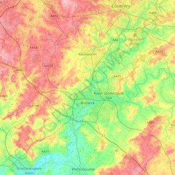
Name: Warwick topographic map, elevation, terrain.
Location: Warwick, Warwickshire, England, United Kingdom (52.21370 -1.78018 52.38928 -1.40608)
Average elevation: 285 ft
Minimum elevation: 115 ft
Maximum elevation: 476 ft
Other topographic maps
Click on a map to view its topography, its elevation and its terrain.
Baddesley Ensor
United Kingdom > England > Warwickshire > North Warwickshire
Average elevation: 364 ft
Nuneaton Common
United Kingdom > England > Warwickshire > Nuneaton and Bedworth
Average elevation: 417 ft
Shipston-on-Stour
United Kingdom > England > Warwickshire > Stratford-on-Avon
Average elevation: 305 ft
Rowington Green
United Kingdom > England > Warwickshire > Warwick > Rowington
Average elevation: 374 ft
Brook End
United Kingdom > England > Warwickshire > North Warwickshire > Hurley
Average elevation: 351 ft
Big Clowes Wood
United Kingdom > England > Warwickshire > Stratford-on-Avon > Tanworth in Arden CP
Average elevation: 499 ft
Gilson
United Kingdom > England > Warwickshire > North Warwickshire > Coleshill CP
Average elevation: 269 ft
Napton on the Hill
United Kingdom > England > Warwickshire > Stratford-on-Avon
Average elevation: 371 ft
Pooley Country Park
United Kingdom > England > Warwickshire > North Warwickshire > Polesworth
Average elevation: 249 ft
Hampton on the Hill
United Kingdom > England > Warwickshire > Warwick > Hampton on the Hill
Average elevation: 246 ft
Burton Dassett Hills Country Park
United Kingdom > England > Warwickshire > Stratford-on-Avon > Northend > Burton Dassett CP
Average elevation: 433 ft
Upper Quinton
United Kingdom > England > Warwickshire > Stratford-on-Avon > Lower Quinton
Average elevation: 230 ft
Lye Green
United Kingdom > England > Warwickshire > Stratford-on-Avon > Claverdon
Average elevation: 348 ft
Hartshill Hayes Country Park
United Kingdom > England > Warwickshire > North Warwickshire > Ansley Common
Average elevation: 417 ft
Cranhill
United Kingdom > England > Warwickshire > Stratford-on-Avon > Ardens Grafton
Average elevation: 187 ft
Curdworth Locks
United Kingdom > England > Warwickshire > North Warwickshire > Kingsbury > Curdworth CP
Average elevation: 262 ft
Oversley Wood
United Kingdom > England > Warwickshire > Stratford-on-Avon > Alcester > Exhall
Average elevation: 210 ft
Merevale Lake
United Kingdom > England > Warwickshire > North Warwickshire > Atherstone
Average elevation: 390 ft
Church End
United Kingdom > England > Warwickshire > North Warwickshire > Ansley CP
Average elevation: 495 ft
Edgehill
United Kingdom > England > Warwickshire > Stratford-on-Avon > Radway
Average elevation: 515 ft
Hill Wootton
United Kingdom > England > Warwickshire > Warwick > Leek Wootton
Average elevation: 226 ft
Sutton-under-Brailes
United Kingdom > England > Warwickshire > Stratford-on-Avon > Stourton
Average elevation: 410 ft
Brinklow Marina
United Kingdom > England > Warwickshire > Rugby > King's Newnham CP
Average elevation: 312 ft
Walton
United Kingdom > England > Warwickshire > Stratford-on-Avon > Wellesbourne
Average elevation: 249 ft
Vale View
United Kingdom > England > Warwickshire > Nuneaton and Bedworth > Nuneaton
Average elevation: 371 ft
Arlescote
United Kingdom > England > Warwickshire > Stratford-on-Avon > Warmington CP
Average elevation: 486 ft
Bishopton
United Kingdom > England > Warwickshire > Stratford-on-Avon > Stratford-upon-Avon
Average elevation: 210 ft
Nether Whitacre
United Kingdom > England > Warwickshire > North Warwickshire
Average elevation: 272 ft
Holbech's Wood
United Kingdom > England > Warwickshire > North Warwickshire > Fillongley CP
Average elevation: 459 ft
Hoar Park
United Kingdom > England > Warwickshire > North Warwickshire > Bentley CP
Average elevation: 443 ft
Hunts Green
United Kingdom > England > Warwickshire > North Warwickshire > Middleton CP
Average elevation: 266 ft
Marlcliff
United Kingdom > England > Warwickshire > Stratford-on-Avon > Bidford on Avon CP
Average elevation: 135 ft
River Avon
United Kingdom > England > Warwickshire > Stratford-on-Avon > Stratford-upon-Avon > Clifford Chambers
Average elevation: 141 ft
Ashorne
United Kingdom > England > Warwickshire > Stratford-on-Avon > Moreton Morrell
Average elevation: 220 ft
Bishop's Itchington
United Kingdom > England > Warwickshire > Stratford-on-Avon
Average elevation: 344 ft
Pillerton Hersey
United Kingdom > England > Warwickshire > Stratford-on-Avon > Pillerton Hersey
Average elevation: 302 ft
Pathlow
United Kingdom > England > Warwickshire > Stratford-on-Avon > Wilmcote CP
Average elevation: 276 ft
Lower Binton
United Kingdom > England > Warwickshire > Stratford-on-Avon > Binton
Average elevation: 171 ft
Lea Marston Purification Lakes
United Kingdom > England > Warwickshire > North Warwickshire > Marston
Average elevation: 230 ft
Horeston Grange
United Kingdom > England > Warwickshire > Nuneaton and Bedworth
Average elevation: 295 ft
Ladbroke (Millennium Green)
United Kingdom > England > Warwickshire > Stratford-on-Avon > Ladbroke CP
Average elevation: 322 ft