
Willey topographic map
Click on the map to display elevation.
About this map
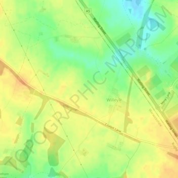
Name: Willey topographic map, elevation, terrain.
Location: Willey, Warwickshire, England, United Kingdom (52.44931 -1.29861 52.47201 -1.25293)
Average elevation: 404 ft
Minimum elevation: 338 ft
Maximum elevation: 446 ft
Other topographic maps
Click on a map to view its topography, its elevation and its terrain.
Clifford Chambers
United Kingdom > England > Warwickshire > Stratford-on-Avon
Average elevation: 157 ft
Shipston-on-Stour
United Kingdom > England > Warwickshire > Stratford-on-Avon
Average elevation: 305 ft
Compton Verney CP
United Kingdom > England > Warwickshire > Stratford-on-Avon
Average elevation: 338 ft
Newton Regis CP
United Kingdom > England > Warwickshire > North Warwickshire
Average elevation: 279 ft
Rowington Green
United Kingdom > England > Warwickshire > Warwick > Rowington
Average elevation: 374 ft
Bidford on Avon CP
United Kingdom > England > Warwickshire > Stratford-on-Avon
Average elevation: 138 ft
Brook End
United Kingdom > England > Warwickshire > North Warwickshire > Hurley
Average elevation: 351 ft
Upper Lighthorne
United Kingdom > England > Warwickshire > Stratford-on-Avon
Average elevation: 377 ft
Stratford-on-Avon
United Kingdom > England > Warwickshire > Stratford-on-Avon
Average elevation: 354 ft
Tanworth in Arden CP
United Kingdom > England > Warwickshire > Stratford-on-Avon
Average elevation: 456 ft
Warwick
United Kingdom > England > Warwickshire
Warwick experiences the usual English maritime climate, marked by a narrow temperature range, mild winters and cool summers. The nearest official Met Office weather station is at Wellesbourne, about 6 miles (10 km) south of the town centre and at a similar elevation. The absolute maximum temperature (also the…
Average elevation: 285 ft
Stratford-upon-Avon
United Kingdom > England > Warwickshire > Stratford-on-Avon
Average elevation: 200 ft
Gilson
United Kingdom > England > Warwickshire > North Warwickshire > Coleshill CP
Average elevation: 269 ft
Napton on the Hill
United Kingdom > England > Warwickshire > Stratford-on-Avon
Average elevation: 371 ft
Fenny Compton CP
United Kingdom > England > Warwickshire > Stratford-on-Avon
Average elevation: 433 ft
Brailes
United Kingdom > England > Warwickshire > Stratford-on-Avon > Lower Brailes
Average elevation: 456 ft
Hampton on the Hill
United Kingdom > England > Warwickshire > Warwick > Hampton on the Hill
Average elevation: 246 ft
Bishops Itchington
United Kingdom > England > Warwickshire > Stratford-on-Avon
Average elevation: 341 ft
Baddesley Ensor
United Kingdom > England > Warwickshire > North Warwickshire
Average elevation: 364 ft
Birmingham and Fazeley Canal
United Kingdom > England > Warwickshire > Minworth
Average elevation: 344 ft
Upper Quinton
United Kingdom > England > Warwickshire > Stratford-on-Avon > Lower Quinton
Average elevation: 230 ft
Lye Green
United Kingdom > England > Warwickshire > Stratford-on-Avon > Claverdon
Average elevation: 348 ft
Stretton-on-Fosse
United Kingdom > England > Warwickshire > Stratford-on-Avon
Average elevation: 354 ft
Priors Hardwick CP
United Kingdom > England > Warwickshire > Stratford-on-Avon
Average elevation: 440 ft
Welford on Avon CP
United Kingdom > England > Warwickshire > Stratford-on-Avon
Average elevation: 144 ft
Cranhill
United Kingdom > England > Warwickshire > Stratford-on-Avon > Ardens Grafton
Average elevation: 187 ft
Curdworth Locks
United Kingdom > England > Warwickshire > North Warwickshire > Kingsbury > Curdworth CP
Average elevation: 262 ft