
Quezon City topographic map
Interactive map
Click on the map to display elevation.
Quezon City
Quezon City is characterized by a diverse topography that features a mix of flatlands, rolling hills, and elevated areas, particularly in the eastern and northern parts of the city. The elevation generally ranges from about 25 to 300 feet above sea level, with higher elevations found in areas like the La Mesa Ecopark, which serves as a significant natural reserve within the urban landscape. The terrain is primarily composed of alluvial plains, which are conducive to urban development but also interspersed with green spaces, such as parks and gardens, providing a balance between concrete structures and nature. The city's natural drainage is aided by several rivers and waterways, including the Tullahan River, which meanders through parts of Quezon City, contributing to both the scenic beauty and the challenges of urban flooding during the rainy season. Overall, Quezon City's varied topography not only influences its urban layout but also plays a crucial role in its ecology and climate.
About this map
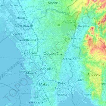
Name: Quezon City topographic map, elevation, terrain.
Average elevation: 187 ft
Minimum elevation: -10 ft
Maximum elevation: 1,923 ft
Other topographic maps
Click on a map to view its topography, its elevation and its terrain.
Benguet
The province suffers from crop damage resulting from seasonal frost during the cold months of December to March, especially in high-altitude towns such as Atok, Buguias, Mankayan and Kibungan. In February 2007, Benguet suffered crop damage due to temperatures reaching as low as 7 °C (45 °F).
Average elevation: 2,897 ft
Panay
Panay island is the sixth largest island in the Philippines by area, with a total land area of 12,011 km2 (4,637 sq mi). Mount Madja-as is the highest point in Panay with an elevation of 2,117 metres (6,946 ft) above sea level, located in town of Culasi in the northern province of Antique. Central Panay…
Average elevation: 384 ft
La Trinidad
The terrain is generally mountainous with springs, rivers and creeks. The town has a valley which encompasses several barangays. The valley floor elevation is at 1,300 metres (4,300 ft) above sea level. Elevation ranges from 500 to 1,700 metres (1,600 to 5,600 ft) above sea level.
Average elevation: 3,684 ft
Ilocos Region
The southern parts of the region were severely hit by the 1990 Luzon earthquake. Five municipalities in La Union were affected: Agoo, Aringay, Caba, Santo Tomas, and Tubao with a combined population of 132,208. Many buildings, including the Agoo Municipal hall, the Museo de Iloko, the parish church of Aringay,…
Average elevation: 719 ft
Cagayan
The eastern coast forms the northern portion of the Sierra Madre mountain range, while the western limits are generally hilly to low in elevation. The central area, dominated by a large valley, forms the lower basin of the country's longest river, the Cagayan. The mouth is located at the northern town of…
Average elevation: 361 ft
Malolos
Malolos is relatively flat of about 0.81% to a gently sloping of 2.17%. The slope of the land descends towards west, southwest to southern direction. The highest land elevation is at about 6.0 m (19.7 ft) above sea level while the lowest is only 0.5 m (1 ft 8 in) below sea level. A network of natural waterways…
Average elevation: 13 ft
Mataasnakahoy
Mataasnakahoy has 16 barangays and its total land area is 22.10 square kilometers (8.53 sq mi). It is bounded by Balete and Lipa City with Taal Lake on its western edge. The town is known for its cool climate due to its high elevation of 379 meters (1,243 ft).
Average elevation: 728 ft
Cotabato City
The city is situated in the lowest portion of Maguindanao province. The City of Cotabato with its 37 barangays spans an area with marked landscapes of flat, level to nearly level, very gently sloping to gently undulations to moderately sloping or rolling. It is basically a delta formed by two big rivers, the…
Average elevation: 213 ft
Baybay
The climate is of Coronas Climate type IV, which is generally wet with no particularly discernible seasons. Its topography is generally mountainous in the eastern portion as it slopes down west towards the shore line. Generally an agricultural city, the common means of livelihood are farming and fishing. Some…
Average elevation: 515 ft
Caballo Island
Philippines > Cavite > Cavite City
Caballo Island (which means "Horse Island" in Spanish) is a bluff, rocky island located at the entrance to Manila Bay in the Philippines. It is about 1.2 km (0.75 mi) long with the highest elevation at 381 feet high. Caballo, along with the larger Corregidor (2 km to the north), divides the entrance to the bay…
Average elevation: 0 ft
Isabela
The province is divided into three physiographic areas. The eastern area, straddled by the Sierra Madre mountain range, is rugged and thickly forested. A substantial portion is uncharted. These unexplored hinterlands are home to a rich variety of flora and fauna, and some are under government reservations. It…
Average elevation: 745 ft
Magsaysay
Philippines > Occidental Mindoro
Magsaysay, one of the eleven municipalities in the Occidental Mindoro, lies on the southernmost part of Mindoro Island, and is adjacent to the municipality of San Jose on the north; on the east separated by chain of valleys and mountains in the municipality of Bulalacao, Oriental Mindoro; on the south, by…
Average elevation: 203 ft
Bukidnon
Situated within Bukidnon is Mount Dulang-dulang, the 2nd highest mountain in the country, with an elevation of 2,938 metres (9,639 ft) located in the Kitanglad Mountain Range. Mount Kitanglad (2,899 m), Mount Kalatungan (2,860 m), Mount Maagnaw (2,742 m), Mount Lumuluyaw (2,612 m), and Mount Tuminungan (2,400…
Average elevation: 2,251 ft
Leyte
Mahagnao Volcano Natural Park Located in Burauen, Leyte, about 66 km (41 mi) from Tacloban City, the Mahagnao Volcano Natural Park attracts visitors with its lakes, craters, hot springs, multi-colored mud, virgin forests and lagoon. It was proclaimed as a national park in 1937. Like other regions in the…
Average elevation: 223 ft
Isabela
The elevation of Isabela to 4th-class city status gave the local government a much-needed boost, efficiently delivered under the Biel administration, revitalized Isabela City, making it an engine of growth for Basilan province even as the hinterlands was wracked by incessant firefights and gun-battles between…
Average elevation: 305 ft
Majayjay
Majayjay is a geographically landlocked area situated in the southernmost part of Laguna. It nestles at the foot of Mt. Banahaw, and due to its higher altitude at some 2,700+ ft above sea level, the town makes for a popular vacation destination during summer in the Philippines. It was once branded as the…
Average elevation: 1,601 ft
Pulilan
The municipality is generally of flat topography. Eleven (11) of its barangays are bounded by the Angat River. The rest are flat irrigated rice lands. Soil types vary from sandy loam to clay loam which makes the municipality suitable to a wide range of agricultural products.
Average elevation: 33 ft