
Make a donation
Gear up for your next adventure:
As an Amazon Associate, this site earns from qualifying purchases at no extra cost to you.
Tugela River topographic map
Click on the map to display elevation.
Make a donation
Gear up for your next adventure:
As an Amazon Associate, this site earns from qualifying purchases at no extra cost to you.
Tugela River
The river originates in Mont-aux-Sources of the Drakensberg Mountains at an elevation of 3 282 metres and plunges in five distinct free-leaping falls 947 metres down the Tugela Falls. The Mont-aux-Sources is also the origin of tributaries of two other major South African rivers, the Orange and the Caledon River. From the Drakensberg range, the Tugela follows a 560 km (350 mi) route through the KwaZulu-Natal midlands before flowing into the Indian Ocean. The total catchment area is approximately 29,100 km2 (11,200 mi2). Land uses in the catchment are mainly rural subsistence farming and commercial forestry.
Make a donation
Gear up for your next adventure:
As an Amazon Associate, this site earns from qualifying purchases at no extra cost to you.
About this map
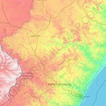
Name: Tugela River topographic map, elevation, terrain.
Location: Tugela River, KwaZulu-Natal, South Africa (-29.22422 28.87589 -28.63395 31.50057)
Average elevation: 3,904 ft
Minimum elevation: -3 ft
Maximum elevation: 11,234 ft
Make a donation
Gear up for your next adventure:
As an Amazon Associate, this site earns from qualifying purchases at no extra cost to you.
Other topographic maps
Click on a map to view its topography, its elevation and its terrain.
Umlazi
South Africa > KwaZulu-Natal > eThekwini Metropolitan Municipality
Umlazi is situated on a series of undulating hills at an average elevation of 101 metres above sea level between the uMlaza River to the north and the uMbokodweni River to the south. Another river running through Umlazi is the Siphingo River which also runs towards the south of the township.
Average elevation: 328 ft
Umdloti / eMdloti
South Africa > KwaZulu-Natal > eThekwini Metropolitan Municipality
eMdloti has a permanent population of around 3,000 people but can increase by as much as tenfold during the Christmas and Easter holiday season. Due to eMdloti's single access road (M27) from the M4/N2 interchanges, the topography, the fact that North and South Beach Roads are both cul-de-sacs and limited…
Average elevation: 125 ft
Make a donation
Gear up for your next adventure:
As an Amazon Associate, this site earns from qualifying purchases at no extra cost to you.
Hlabisa
South Africa > KwaZulu-Natal > Umkhanyakude District Municipality > Hlabisa Local Municipality
Average elevation: 1,581 ft
Stanger / KwaDukuza
South Africa > KwaZulu-Natal > iLembe District Municipality > KwaDukuza Local Municipality
Average elevation: 315 ft
Eshowe
South Africa > KwaZulu-Natal > King Cetswayo District Municipality > uMlalazi Local Municipality
Average elevation: 1,499 ft
Umbumbulu
South Africa > KwaZulu-Natal > eThekwini Metropolitan Municipality
Average elevation: 1,663 ft
Make a donation
Gear up for your next adventure:
As an Amazon Associate, this site earns from qualifying purchases at no extra cost to you.
Umkomaas
South Africa > KwaZulu-Natal > eThekwini Metropolitan Municipality
The Umkomaas or uMkomazi River is a dominant feature of the area, being the largest river on the South Coast. The river is 298 kilometres long, from its source just south of Giant's Castle in the uKhahlamba / Drakensberg Park World Heritage Site to its mouth on the Indian Ocean. The river begins its journey at…
Average elevation: 125 ft
oThongathi
South Africa > KwaZulu-Natal > eThekwini Metropolitan Municipality
Average elevation: 240 ft
Estcourt
South Africa > KwaZulu-Natal > Uthukela District Municipality > Umtshezi Local Municipality
Average elevation: 3,950 ft
Port Shepstone
South Africa > KwaZulu-Natal > Ugu District Municipality > Hibiscus Coast Local Municipality
Port Shepstone's topography is characterised by a rugged/hilly terrain with the Central Business District (CBD) lying on a large hill overlooking the Indian Ocean. Port Shepstone proper (excluding its extensions) is bordered by the uMzimkhulu River to the north and the N2 freeway to the east and is also…
Average elevation: 108 ft
Make a donation
Gear up for your next adventure:
As an Amazon Associate, this site earns from qualifying purchases at no extra cost to you.
Pinetown
South Africa > KwaZulu-Natal > eThekwini Metropolitan Municipality
Topographically, Pinetown is generally hilly with the exception of the central business district which is relatively flatter by comparison to the surrounding suburban areas. The notable high-lying areas in the eastern parts of Pinetown include Cowies Hill and the New Germany Nature Reserve reaching…
Average elevation: 1,168 ft
Umzimkulu
South Africa > KwaZulu-Natal > Sisonke District Municipality > Umzimkhulu Local Municipality
Average elevation: 2,503 ft
Make a donation
Gear up for your next adventure:
As an Amazon Associate, this site earns from qualifying purchases at no extra cost to you.
Salt Rock
South Africa > KwaZulu-Natal > iLembe District Municipality > KwaDukuza Local Municipality
Average elevation: 118 ft
Palmiet River
South Africa > KwaZulu-Natal > eThekwini Metropolitan Municipality > Pinetown
Average elevation: 1,010 ft
Pietermaritzburg
South Africa > KwaZulu-Natal > uMgungundlovu District Municipality
Average elevation: 2,799 ft
Howick
South Africa > KwaZulu-Natal > uMgungundlovu District Municipality > uMgeni Local Municipality
Howick is possibly the location of the first crewed flight in the world. Evidence exists that a John Goodman Household flew a self made glider in 1871 and again in 1875 on the outskirts of Howick, close to Karkloof. The actual distance flown and altitude achieved differs from source to source (some sources say…
Average elevation: 3,497 ft
Make a donation
Gear up for your next adventure:
As an Amazon Associate, this site earns from qualifying purchases at no extra cost to you.
Pongola
South Africa > KwaZulu-Natal > Zululand District Municipality > uPhongolo Local Municipality
Average elevation: 955 ft
Hillcrest
South Africa > KwaZulu-Natal > eThekwini Metropolitan Municipality
Hillcrest is situated in the Upper Highway Area of Durban, approximately 32 kilometres (20 mi) north-west of the city and is bordered by Gillitts and Everton to the east, Waterfall to the north-east and Botha's Hill and Assagay to the north-west. It lies at an altitude of approximately 680 m (2231 ft) above…
Average elevation: 2,051 ft
Ballito
South Africa > KwaZulu-Natal > iLembe District Municipality > KwaDukuza Local Municipality
Average elevation: 102 ft
Durban North
South Africa > KwaZulu-Natal > eThekwini Metropolitan Municipality
Average elevation: 135 ft
Make a donation
Gear up for your next adventure:
As an Amazon Associate, this site earns from qualifying purchases at no extra cost to you.
Umhlanga Rocks
South Africa > KwaZulu-Natal > eThekwini Metropolitan Municipality
Average elevation: 148 ft
Nquthu
South Africa > KwaZulu-Natal > Umzinyathi District Municipality > Nquthu Local Municipality
Average elevation: 3,855 ft
Mtubatuba
South Africa > KwaZulu-Natal > Umkhanyakude District Municipality > Mtubatuba Local Municipality
Average elevation: 210 ft
Make a donation
Gear up for your next adventure:
As an Amazon Associate, this site earns from qualifying purchases at no extra cost to you.
Ulundi
South Africa > KwaZulu-Natal > Zululand District Municipality > Ulundi Local Municipality
Average elevation: 1,923 ft
Ixopo
South Africa > KwaZulu-Natal > Sisonke District Municipality > Ubuhlebezwe Local Municipality
Average elevation: 3,310 ft
Richards Bay
South Africa > KwaZulu-Natal > King Cetswayo District Municipality
Average elevation: 102 ft
Make a donation
Gear up for your next adventure:
As an Amazon Associate, this site earns from qualifying purchases at no extra cost to you.
Weenen
South Africa > KwaZulu-Natal > Uthukela District Municipality > Umtshezi Local Municipality
Average elevation: 2,854 ft
Kloof
South Africa > KwaZulu-Natal > eThekwini Metropolitan Municipality
The further subdivisions and sale of portions of Richmond Farm No. 999 by the Field heirs after 1901 resulted in the birth of Kloof as a residential area: numerous plots were sold to wealthy Durban residents and businessmen, who built country house retreats close to the city, but (due to its 550 m above sea…
Average elevation: 1,575 ft
Port Edward
South Africa > KwaZulu-Natal > Ugu District Municipality > Hibiscus Coast Local Municipality
Average elevation: 138 ft
Majuba
South Africa > KwaZulu-Natal > Amajuba District Municipality > Newcastle Local Municipality
Average elevation: 5,906 ft
Make a donation
Gear up for your next adventure:
As an Amazon Associate, this site earns from qualifying purchases at no extra cost to you.
Vryheid
South Africa > KwaZulu-Natal > Zululand District Municipality > Abaqulusi Local Municipality
Average elevation: 3,907 ft
Chatsworth
South Africa > KwaZulu-Natal > eThekwini Metropolitan Municipality
Average elevation: 489 ft
Empangeni
South Africa > KwaZulu-Natal > King Cetswayo District Municipality > uMhlathuze Local Municipality
Average elevation: 292 ft
Umlazi
South Africa > KwaZulu-Natal > eThekwini Metropolitan Municipality
Umlazi is approximately 15 kilometres (9 mi) south-west of the Durban CBD, between the uMlaza River to the north and uMbokodweni River to the south, with the smaller Siphingo River flowing in the southern parts of the township. It lies at an average altitude of approximately 101 m (331 ft) above sea level in…
Average elevation: 328 ft
Make a donation
Gear up for your next adventure:
As an Amazon Associate, this site earns from qualifying purchases at no extra cost to you.
Kosi Bay Rest Camp
South Africa > KwaZulu-Natal > Umkhanyakude District Municipality > uMhlabuyalingana Local Municipality
Average elevation: 36 ft
Richmond
South Africa > KwaZulu-Natal > uMgungundlovu District Municipality > Richmond Local Municipality
Average elevation: 2,976 ft
Sodwana Bay
South Africa > KwaZulu-Natal > Umkhanyakude District Municipality > The Big Five False Bay Local Municipality
Average elevation: 52 ft
Make a donation
Gear up for your next adventure:
As an Amazon Associate, this site earns from qualifying purchases at no extra cost to you.
Umgeni River
South Africa > KwaZulu-Natal > eThekwini Metropolitan Municipality > Queensburgh
Average elevation: 430 ft
uMngeni River
South Africa > KwaZulu-Natal > uMgungundlovu District Municipality > uMgeni Local Municipality > Howick
Average elevation: 3,399 ft
Mwgahumbe
South Africa > KwaZulu-Natal > uMgungundlovu District Municipality > Mkhambathini Local Municipality
Average elevation: 1,877 ft
Mkuze River
South Africa > KwaZulu-Natal > Zululand District Municipality > uPhongolo Local Municipality
Average elevation: 1,165 ft
Make a donation
Gear up for your next adventure:
As an Amazon Associate, this site earns from qualifying purchases at no extra cost to you.
Pomeroy
South Africa > KwaZulu-Natal > Umzinyathi District Municipality > Msinga Local Municipality
Average elevation: 3,707 ft
KwaMakhutha
South Africa > KwaZulu-Natal > eThekwini Metropolitan Municipality
Average elevation: 295 ft
Pigeon Valley
South Africa > KwaZulu-Natal > eThekwini Metropolitan Municipality > Durban
Average elevation: 226 ft
Nkandla
South Africa > KwaZulu-Natal > King Cetswayo District Municipality > Nkandla Local Municipality
Average elevation: 3,412 ft
Make a donation
Gear up for your next adventure:
As an Amazon Associate, this site earns from qualifying purchases at no extra cost to you.
Shaka's Rock
South Africa > KwaZulu-Natal > iLembe District Municipality > KwaDukuza Local Municipality
Average elevation: 118 ft
Ramsgate
South Africa > KwaZulu-Natal > Ugu District Municipality > Hibiscus Coast Local Municipality
Average elevation: 95 ft
Dundee
South Africa > KwaZulu-Natal > Umzinyathi District Municipality > Endumeni Local Municipality
Average elevation: 4,144 ft
Nottingham Road
South Africa > KwaZulu-Natal > uMgungundlovu District Municipality > uMgeni Local Municipality
Average elevation: 4,849 ft
Make a donation
Gear up for your next adventure:
As an Amazon Associate, this site earns from qualifying purchases at no extra cost to you.
Manguzi
South Africa > KwaZulu-Natal > Umkhanyakude District Municipality > uMhlabuyalingana Local Municipality
Average elevation: 144 ft
Forest Hills
South Africa > KwaZulu-Natal > eThekwini Metropolitan Municipality
Average elevation: 1,581 ft
Sikhalasenkosi
South Africa > KwaZulu-Natal > King Cetswayo District Municipality > uMhlathuze Local Municipality
Average elevation: 105 ft
Phakamisa
South Africa > KwaZulu-Natal > Zululand District Municipality > uPhongolo Local Municipality
Average elevation: 1,637 ft
Make a donation
Gear up for your next adventure:
As an Amazon Associate, this site earns from qualifying purchases at no extra cost to you.
eMondlo
South Africa > KwaZulu-Natal > Zululand District Municipality > Abaqulusi Local Municipality
Average elevation: 3,780 ft
Mpungamhlophe
South Africa > KwaZulu-Natal > Zululand District Municipality > Ulundi Local Municipality
Average elevation: 2,411 ft
Isandlwana
South Africa > KwaZulu-Natal > Umzinyathi District Municipality > Nquthu Local Municipality
Average elevation: 3,904 ft
Mpumalanga
South Africa > KwaZulu-Natal > eThekwini Metropolitan Municipality
Average elevation: 1,909 ft
Make a donation
Gear up for your next adventure:
As an Amazon Associate, this site earns from qualifying purchases at no extra cost to you.
Shelly Beach
South Africa > KwaZulu-Natal > Ugu District Municipality > Hibiscus Coast Local Municipality
Average elevation: 82 ft
Southbroom
South Africa > KwaZulu-Natal > Ugu District Municipality > Hibiscus Coast Local Municipality
Average elevation: 98 ft
Mtunzini
South Africa > KwaZulu-Natal > King Cetswayo District Municipality > uMlalazi Local Municipality
Average elevation: 98 ft
Queensburgh
South Africa > KwaZulu-Natal > eThekwini Metropolitan Municipality
Average elevation: 571 ft
Make a donation
Gear up for your next adventure:
As an Amazon Associate, this site earns from qualifying purchases at no extra cost to you.
Izingolweni
South Africa > KwaZulu-Natal > Ugu District Municipality > Ezinqoleni Local Municipality
Average elevation: 1,811 ft
Tugela
South Africa > KwaZulu-Natal > iLembe District Municipality > Mandeni Local Municipality
Average elevation: 200 ft
Tugela Falls
South Africa > KwaZulu-Natal > Uthukela District Municipality > Okhahlamba Local Municipality
First, many now believe that Angel Falls is not as tall as was claimed in the initial survey carried out by American journalist Ruth Robertson in 1949. The quoted figure of 979 m (3,212 ft) corresponds almost precisely with the difference in altitude between the top of the falls and the confluence of the Rio…
Average elevation: 9,098 ft
Ngolotshe
South Africa > KwaZulu-Natal > Zululand District Municipality > Nongoma Local Municipality
Average elevation: 551 ft
Make a donation
Gear up for your next adventure:
As an Amazon Associate, this site earns from qualifying purchases at no extra cost to you.
Umbilo River
South Africa > KwaZulu-Natal > eThekwini Metropolitan Municipality > Durban
Average elevation: 184 ft
Umzimkulu
South Africa > KwaZulu-Natal > Sisonke District Municipality > Kwa Sani Local Municipality
Average elevation: 4,997 ft
Make a donation
Gear up for your next adventure:
As an Amazon Associate, this site earns from qualifying purchases at no extra cost to you.
Melmoth
South Africa > KwaZulu-Natal > King Cetswayo District Municipality > Mthonjaneni Local Municipality
Average elevation: 2,536 ft
Cape Vidal
South Africa > KwaZulu-Natal > Umkhanyakude District Municipality > Mtubatuba Local Municipality
Average elevation: 62 ft
Madadeni
South Africa > KwaZulu-Natal > Amajuba District Municipality > Newcastle Local Municipality
Average elevation: 3,924 ft
Dukuduku
South Africa > KwaZulu-Natal > Umkhanyakude District Municipality > Mtubatuba Local Municipality
Average elevation: 128 ft
Make a donation
Gear up for your next adventure:
As an Amazon Associate, this site earns from qualifying purchases at no extra cost to you.
Bambanandi
South Africa > KwaZulu-Natal > Zululand District Municipality > uPhongolo Local Municipality
Average elevation: 2,894 ft
KwaDuma
South Africa > KwaZulu-Natal > Zululand District Municipality > Nongoma Local Municipality
Average elevation: 1,749 ft
eChibini Tarn
South Africa > KwaZulu-Natal > uMgungundlovu District Municipality > Impendle Local Municipality
Average elevation: 7,526 ft
Highflats
South Africa > KwaZulu-Natal > Sisonke District Municipality > Ubuhlebezwe Local Municipality
Average elevation: 3,166 ft
Make a donation
Gear up for your next adventure:
As an Amazon Associate, this site earns from qualifying purchases at no extra cost to you.
Glenmore
South Africa > KwaZulu-Natal > Ugu District Municipality > Hibiscus Coast Local Municipality
Average elevation: 118 ft
Amatikulu
South Africa > KwaZulu-Natal > King Cetswayo District Municipality > uMlalazi Local Municipality
Average elevation: 177 ft
Nyanyadu
South Africa > KwaZulu-Natal > Amajuba District Municipality > Dannhauser Local Municipality
Average elevation: 4,626 ft
Kokstad
South Africa > KwaZulu-Natal > Sisonke District Municipality > Greater Kokstad Local Municipality
Average elevation: 4,390 ft
Make a donation
Gear up for your next adventure:
As an Amazon Associate, this site earns from qualifying purchases at no extra cost to you.
Bluff Nature Reserve
South Africa > KwaZulu-Natal > eThekwini Metropolitan Municipality > Durban
Average elevation: 125 ft
Mehlomnyama Nature Reserve
South Africa > KwaZulu-Natal > Ugu District Municipality > Umzumbe Local Municipality
Average elevation: 1,243 ft
St. Lucia
South Africa > KwaZulu-Natal > Umkhanyakude District Municipality > Mtubatuba Local Municipality
Average elevation: 26 ft
Umtentweni
South Africa > KwaZulu-Natal > Ugu District Municipality > Hibiscus Coast Local Municipality
Average elevation: 105 ft
Make a donation
Gear up for your next adventure:
As an Amazon Associate, this site earns from qualifying purchases at no extra cost to you.
Mohlesi (Umkomass)
South Africa > KwaZulu-Natal > uMgungundlovu District Municipality > Impendle Local Municipality
Average elevation: 10,213 ft
Umbogintwini
South Africa > KwaZulu-Natal > eThekwini Metropolitan Municipality
Average elevation: 98 ft
Harding
South Africa > KwaZulu-Natal > Ugu District Municipality > uMuziwabantu Local Municipality
Average elevation: 2,881 ft
Hluhluwe
South Africa > KwaZulu-Natal > Umkhanyakude District Municipality > The Big Five False Bay Local Municipality
Average elevation: 233 ft
Make a donation
Gear up for your next adventure:
As an Amazon Associate, this site earns from qualifying purchases at no extra cost to you.
Underberg
South Africa > KwaZulu-Natal > Sisonke District Municipality > Kwa Sani Local Municipality
Average elevation: 5,092 ft
Charlestown
South Africa > KwaZulu-Natal > Amajuba District Municipality > Newcastle Local Municipality
Average elevation: 5,410 ft
Scottburgh
South Africa > KwaZulu-Natal > Ugu District Municipality > uMdoni Local Municipality
Average elevation: 118 ft
Albert Falls
South Africa > KwaZulu-Natal > uMgungundlovu District Municipality > uMshwathi Local Municipality
Average elevation: 2,172 ft
Make a donation
Gear up for your next adventure:
As an Amazon Associate, this site earns from qualifying purchases at no extra cost to you.