
Maharashtra topographic map
Interactive map
Click on the map to display elevation.
About this map
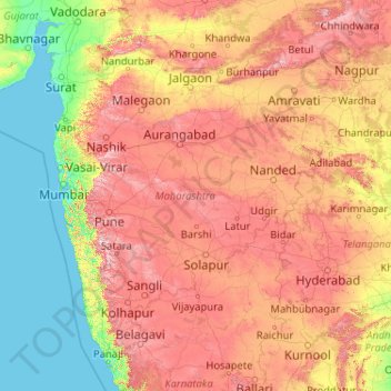
Name: Maharashtra topographic map, elevation, terrain.
Location: Maharashtra, India (15.60636 72.65261 22.03025 80.89778)
Average elevation: 1,135 ft
Minimum elevation: -3 ft
Maximum elevation: 4,652 ft
Maharashtra with a total area of 307,713 km2 (118,809 sq mi), is the third-largest state by area in terms of land area and constitutes 9.36 per cent of India's total geographical area. The State lies between 15°35' N to 22°02' N latitude and 72°36' E to 80°54' E longitude. It occupies the western and central part of the country and has a coastline stretching 840 kilometres along the Arabian Sea. The dominant physical feature of the state is its plateau character, which is separated from the Konkan coastline by the mountain range of the Western Ghats, which runs parallel to the coast from north to south.The Western Ghats, also known as the Sahyadri Range, has an average elevation of 1,200 metres (4,000 ft); its slopes gently descending towards the east and southeast. The Western Ghats (or the Sahyadri Mountain range) provide a physical barrier to the state on the west, while the Satpura Hills along the north and Bhamragad-Chiroli-Gaikhuri ranges on the east serve as its natural borders. This state's expansion from North to South is 700 km and East to West is 800 km. To the west of these hills lie the Konkan coastal plains, 50–80 kilometres in width. To the east of the Ghats lies the flat Deccan Plateau. The main rivers of the state are the Krishna, and its tributary, Bhima, the Godavari, and its main tributaries, Manjara, and Wardha-Wainganga and the Tapi, and its tributary Purna. Maharashtra is divided into five geographic regions. Konkan is the western coastal region, between the Western Ghats and the sea. Khandesh is the north region lying in the valley of the Tapti, Purna river. Nashik, Malegaon Jalgaon, Dhule and Bhusawal are the major cities of this region. Desh is in the center of the state. Marathwada, which was a part of the princely state of Hyderabad until 1956, is located in the southeastern part of the state. Aurangabad and Nanded are the main cities of the region. Vidarbha is the easternmost region of the state, formerly part of the Central Provinces and Berar.
Other topographic maps
Click on a map to view its topography, its elevation and its terrain.
Sheoganj
India > Rajasthan > Sheoganj Tehsil
Sheoganj, Sheoganj Tehsil, Sirohi District, Rajasthan, 306902, India
Average elevation: 889 ft
Pokaran
India > Rajasthan > Pokaran Tehsil
Pokaran, Pokaran Tehsil, Jaisalmer District, Rajasthan, India
Average elevation: 751 ft
Delwara
India > Madhya Pradesh > Tyonda Tahsil
Delwara, Tyonda Tahsil, Vidisha District, Madhya Pradesh, India
Average elevation: 1,398 ft
Singahalli
India > Karnataka > Kolar taluk
Singahalli, Kolar taluk, Kolar District, Karnataka, India
Average elevation: 2,799 ft
3d
India > Rajasthan > Ganganagar Tehsil > 1 LNP
3d, 1 LNP, Ganganagar Tehsil, Sri Ganganagar District, Rajasthan, India
Average elevation: 584 ft
Elimukku
India > Kerala > Kozhencherry
Elimukku, Kozhencherry, Pathanamthitta District, Kerala, 689504, India
Average elevation: 95 ft
Rohru
Rohru, Shimla District, Himachal Pradesh, 171207, India
Average elevation: 7,474 ft
Tral
Tral, Pulwama District, Jammu and Kashmir, 192123, India
Average elevation: 8,294 ft
Panner Jageer
India > Jammu and Kashmir > Tral
Panner Jageer, Tral, Pulwama District, Jammu and Kashmir, India
Average elevation: 6,631 ft
Malappuram
Malappuram, Ernad, Malappuram District, Kerala, India
Average elevation: 184 ft
Taiba
India > Jharkhand > Erki(Tamar II)
Taiba, Erki(Tamar II), Khunti District, Jharkhand, India
Average elevation: 1,850 ft
Surat
India > Gujarat > Katargam Taluka
Surat, Katargam Taluka, Surat District, Gujarat, 395008, India
Average elevation: 43 ft
Ameenpur mandal
Ameenpur mandal, Sangareddy District, Telangana, India
Average elevation: 1,811 ft
Sreekandapuram
India > Kerala > Taliparamba
Sreekandapuram, Taliparamba, Kannur District, Kerala, 670631, India
Average elevation: 230 ft
Kulana
India > Punjab > Budhlada Tahsil
Kulana, Budhlada Tahsil, Mansa District, Punjab, India
Average elevation: 725 ft
Hukkeri
India > Karnataka > Hukkeri taluk
Hukkeri, Hukkeri taluk, Karnataka, 591309, India
Average elevation: 2,162 ft
Patauda
India > Madhya Pradesh > Unchahara Tahsil
Patauda, Unchahara Tahsil, Satna District, Madhya Pradesh, India
Average elevation: 1,106 ft
Sector 37D
India > Haryana > Gurugram District
Sector 37D, Gurgaon, Gurugram District, Haryana, India
Average elevation: 712 ft
Nakrekal
India > Telangana > Nakrekal mandal
Nakrekal, Nakrekal mandal, Nalgonda District, Telangana, 508211, India
Average elevation: 679 ft
Manjavadi
India > Tamil Nadu > Kilvelur > Anaimangalam
Manjavadi, Anaimangalam, Kilvelur, Nagapattinam District, Tamil Nadu, 611104, India
Average elevation: 16 ft
Lal Kuan
India > Uttar Pradesh > Ghaziabad
Lal Kuan, Ghaziabad, Ghaziabad District, Uttar Pradesh, 201016, India
Average elevation: 692 ft
Chandupatla
India > Telangana > Maddirala mandal
Chandupatla, Maddirala mandal, Suryapet District, Telangana, India
Average elevation: 633 ft
Sengipatti
India > Tamil Nadu > Thanjavur
Sengipatti, Thanjavur, Thanjavur District, Tamil Nadu, India
Average elevation: 259 ft
Dehradun
India > Uttarakhand > Dehradun
Dehradun, Dehradun District, Uttarakhand, 248001, India
Average elevation: 2,966 ft
Ramchandrapuram
India > Andhra Pradesh > A.Konduru
Ramchandrapuram, A.Konduru, NTR, Andhra Pradesh, India
Average elevation: 322 ft
Simandhar Tenements & Flats
India > Gujarat > Mahesana Taluka
Simandhar Tenements & Flats, Mahesana Taluka, Mahesana District, Gujarat, 384001, India
Average elevation: 285 ft
Kadungalloor
India > Kerala > Paravur > Edayar
Kadungalloor, Edayar, Paravur, Ernakulam District, Kerala, India
Average elevation: 26 ft
Shast
India > Himachal Pradesh > Kotkhai
Shast, Kotkhai, Shimla District, Himachal Pradesh, 171204, India
Average elevation: 7,516 ft
Haraluru
India > Karnataka > Tumkur taluk
Haraluru, Tumkur taluk, Tumakuru District, Karnataka, India
Average elevation: 2,835 ft
Shivpuri District
Shivpuri District, Madhya Pradesh, India
Average elevation: 1,184 ft
Duldula
India > Chhattisgarh > Duldula Tahsil
Duldula, Duldula Tahsil, Jashpur District, Chhattisgarh, 496334, India
Average elevation: 1,739 ft
Jodhpur
India > Rajasthan > Jodhpur Tehsil
Jodhpur, Jodhpur Tehsil, Jodhpur District, Rajasthan, India
Average elevation: 781 ft
Boroonda
India > Rajasthan > Pipar City Tehsil
Boroonda, Pipar City Tehsil, Jodhpur(Rural) District, Rajasthan, India
Average elevation: 1,004 ft
Gubbalala
India > Karnataka > Bangalore South
Gubbalala, Bangalore South, Bengaluru Urban, Karnataka, 560062, India
Average elevation: 2,871 ft
Gairan Wasti
India > Maharashtra > Dharashiv > Waruda
Gairan Wasti, Waruda, Dharashiv, Dharashiv District, Maharashtra, India
Average elevation: 2,175 ft
Indian subcontinent
India > Maharashtra > Arni
Indian subcontinent, Arni, Yavatmal, Maharashtra, India
Average elevation: 1,155 ft
Shadnagar
India > Telangana > Farooqnagar mandal
Shadnagar, Farooqnagar mandal, Ranga Reddy District, Telangana, 509216, India
Average elevation: 2,073 ft
Tamluk
Tamluk, Purba Medinipur District, West Bengal, India
Average elevation: 13 ft
Digdoh
India > Maharashtra > Nagpur Urban Taluka
Digdoh, Nagpur Urban Taluka, Nagpur District, Maharashtra, 440019, India
Average elevation: 1,070 ft
Sonbhadra
India > Bihar > Sonbhadra Banshi Suryapur
Sonbhadra, Sonbhadra Banshi Suryapur, Arwal District, Bihar, 824120, India
Average elevation: 243 ft
Sulai
India > Rajasthan > Kherwara Tehsil
Sulai, Kherwara Tehsil, Udaipur District, Rajasthan, India
Average elevation: 1,296 ft