
La Blanca topographic map
Interactive map
Click on the map to display elevation.
About this map
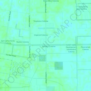
Name: La Blanca topographic map, elevation, terrain.
Location: La Blanca, Hidalgo County, Texas, 78558, United States (26.27265 -98.05790 26.31265 -98.01790)
Average elevation: 75 ft
Minimum elevation: 66 ft
Maximum elevation: 85 ft
Other topographic maps
Click on a map to view its topography, its elevation and its terrain.
McAllen
United States > Texas > Hidalgo County
McAllen, Hidalgo County, Texas, United States
Average elevation: 131 ft
Val Verde
United States > Texas > Hidalgo County > Donna
Val Verde, Donna, Hidalgo County, Texas, 78537, United States
Average elevation: 98 ft
Edcouch
United States > Texas > Hidalgo County
Edcouch, Hidalgo County, Texas, 78538, United States
Average elevation: 66 ft
Indian Hills
United States > Texas > Hidalgo County
Indian Hills, Hidalgo County, Texas, United States
Average elevation: 66 ft
North Alamo
United States > Texas > Hidalgo County
North Alamo, Hidalgo County, Texas, 78589, United States
Average elevation: 105 ft
Heidelberg
United States > Texas > Hidalgo County
Heidelberg, Hidalgo County, Texas, United States
Average elevation: 62 ft
Pharr
United States > Texas > Hidalgo County
Pharr, Hidalgo County, Texas, 78577, United States
Average elevation: 105 ft
Weslaco
United States > Texas > Hidalgo County
Weslaco, Hidalgo County, Texas, 78596, United States
Average elevation: 79 ft
Doolittle
United States > Texas > Hidalgo County > Edinburg
Doolittle, Edinburg, Hidalgo County, Texas, 78542, United States
Average elevation: 89 ft
Cerrito Colonia
United States > Texas > Hidalgo County
Cerrito Colonia, Hidalgo County, Texas, United States
Average elevation: 66 ft
Palmview
United States > Texas > Hidalgo County
Palmview, Hidalgo County, Texas, United States
Average elevation: 141 ft
Blue Star Enterprises Number 2 Colonia
United States > Texas > Hidalgo County > Sullivan City
Blue Star Enterprises Number 2 Colonia, Sullivan City, Hidalgo County, Texas, 78595, United States
Average elevation: 230 ft
R C Babb Colonia
United States > Texas > Hidalgo County
R C Babb Colonia, Hidalgo County, Texas, 78596, United States
Average elevation: 79 ft
Tri-City Colonia Number 1
United States > Texas > Hidalgo County > Alton
Tri-City Colonia Number 1, Alton, Hidalgo County, Texas, 78573, United States
Average elevation: 151 ft
San Juan
United States > Texas > Hidalgo County
San Juan, Hidalgo County, Texas, 78589, United States
Average elevation: 102 ft
Granjeno
United States > Texas > Hidalgo County
Granjeno, Hidalgo County, Texas, United States
Average elevation: 105 ft
West Sharyland
United States > Texas > Hidalgo County
West Sharyland, Hidalgo County, Texas, 78573, United States
Average elevation: 171 ft
Alamo Orchards Colonia
United States > Texas > Hidalgo County > Alamo
Alamo Orchards Colonia, Alamo, Hidalgo County, Texas, 78516, United States
Average elevation: 102 ft
Boyd Colonia Number 1
United States > Texas > Hidalgo County > Mercedes
Boyd Colonia Number 1, Mercedes, Hidalgo County, Texas, 78570, United States
Average elevation: 69 ft
La Villa
United States > Texas > Hidalgo County
La Villa, Hidalgo County, Texas, 78562, United States
Average elevation: 62 ft
Las Brisas Colonia
United States > Texas > Hidalgo County > Mission
Las Brisas Colonia, Mission, Hidalgo County, Texas, 78574, United States
Average elevation: 144 ft
South Palm Gardens Estates Number 1 Colonia
United States > Texas > Hidalgo County > Weslaco
South Palm Gardens Estates Number 1 Colonia, Weslaco, Hidalgo County, Texas, 78596, United States
Average elevation: 75 ft
Gomez Colonia
United States > Texas > Hidalgo County > Pharr
Gomez Colonia, Pharr, Hidalgo County, Texas, 78539, United States
Average elevation: 108 ft
Linn
United States > Texas > Hidalgo County
Linn, Hidalgo County, Texas, United States
Average elevation: 75 ft
Trosper Road Colonia
United States > Texas > Hidalgo County > Alton
Trosper Road Colonia, Alton, Hidalgo County, Texas, 78573, United States
Average elevation: 167 ft
Seville Park Number 1 Colonia
United States > Texas > Hidalgo County > Edinburg
Seville Park Number 1 Colonia, Edinburg, Hidalgo County, Texas, 78539, United States
Average elevation: 105 ft
McAllen
United States > Texas > Hidalgo County > McAllen
McAllen, Hidalgo County, Texas, 78501, United States
Average elevation: 121 ft
Doffing
United States > Texas > Hidalgo County > Doffing
Doffing, Hidalgo County, Texas, 78560, United States
Average elevation: 187 ft
Palmview
United States > Texas > Hidalgo County > Palmview > Palmview
Palmview, Hidalgo County, Texas, 78572, United States
Average elevation: 148 ft
Wood Colonia
United States > Texas > Hidalgo County > Edinburg > Wood Colonia
Wood Colonia, Edinburg, Hidalgo County, Texas, 78540, United States
Average elevation: 102 ft
Palm Heights Colonia
United States > Texas > Hidalgo County > Pharr > Palm Heights Colonia
Palm Heights Colonia, Pharr, Hidalgo County, Texas, 78502, United States
Average elevation: 118 ft
15 1/2 North-FM 491 Colonia
United States > Texas > Hidalgo County > 15 1/2 North-FM 491 Colonia
15 1/2 North-FM 491 Colonia, Hidalgo County, Texas, 78562, United States
Average elevation: 62 ft
Aloha Village Colonia
United States > Texas > Hidalgo County > Alton > Aloha Village Colonia
Aloha Village Colonia, Alton, Hidalgo County, Texas, 78573, United States
Average elevation: 167 ft
Los Angeles
United States > Texas > Hidalgo County > Los Angeles
Los Angeles, Hidalgo County, Texas, United States
Average elevation: 79 ft
La Joya
United States > Texas > Hidalgo County
La Joya, Hidalgo County, Texas, United States
Average elevation: 157 ft
Alamo
United States > Texas > Hidalgo County
Alamo, Hidalgo County, Texas, 78516, United States
Average elevation: 102 ft
San Juan South Estates Colonia
United States > Texas > Hidalgo County > San Juan
San Juan South Estates Colonia, San Juan, Hidalgo County, Texas, 78589, United States
Average elevation: 112 ft
Mission
United States > Texas > Hidalgo County
Mission, Hidalgo County, Texas, United States
Average elevation: 128 ft
Edinburg
United States > Texas > Hidalgo County
Edinburg, Hidalgo County, Texas, United States
Average elevation: 105 ft
Weslaco
United States > Texas > Hidalgo County > Weslaco
Weslaco, Hidalgo County, Texas, 78596, United States
Average elevation: 79 ft
Donna
United States > Texas > Hidalgo County
Donna, Hidalgo County, Texas, 78537, United States
Average elevation: 89 ft