
Khalsi tehsil topographic map
Interactive map
Click on the map to display elevation.
About this map
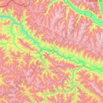
Name: Khalsi tehsil topographic map, elevation, terrain.
Location: Khalsi tehsil, Leh District, Ladakh, India (33.80433 76.41929 34.79610 77.25861)
Average elevation: 14,731 ft
Minimum elevation: 9,288 ft
Maximum elevation: 20,259 ft
Other topographic maps
Click on a map to view its topography, its elevation and its terrain.
Koyul
India > Ladakh > Leh Tehsil
Koyul, Leh Tehsil, Leh District, Ladakh, India
Average elevation: 14,436 ft
Rinam
India > Ladakh > Zanskar tehsil
Rinam, Zanskar tehsil, Kargil District, Ladakh, India
Average elevation: 11,975 ft
Leh Palace
India > Ladakh > Leh Tehsil > Leh
Leh Palace, Sankar Road, Zangsti, Leh, Leh Tehsil, Leh District, Ladakh, India
Average elevation: 11,699 ft
Hanle
India > Ladakh > Leh Tehsil
Hanle, Leh Tehsil, Leh district, Ladakh, India
Average elevation: 14,065 ft
Karu
India > Ladakh > Leh Tehsil
Karu, Leh Tehsil, Leh district, Ladakh, 194201, India
Average elevation: 11,325 ft
Rasar La
India > Ladakh > Leh Tehsil
Rasar La, Leh Tehsil, Leh district, Ladakh, India
Average elevation: 17,897 ft
Chushul
India > Ladakh > Leh Tehsil > Chushul
Chushul, Leh Tehsil, Leh district, Ladakh, India
Average elevation: 14,419 ft
Indus
India > Ladakh > Leh Tehsil
Indus, Leh Tehsil, Leh District, Ladakh, India
Average elevation: 13,753 ft
Stok Kangri 6140 m
Stok Kangri 6140 m, Leh, Leh District, Ladakh, India
Average elevation: 18,251 ft
Arganglas group
Arganglas group, Leh District, Ladakh, India
Average elevation: 16,811 ft
Leh
India > Ladakh > Leh Tehsil
Leh, Leh Tehsil, Leh District, Ladakh, India
Average elevation: 11,985 ft
Karzok
India > Ladakh > Leh Tehsil > Karzok
Karzok, Leh Tehsil, Leh district, Ladakh, India
Average elevation: 15,151 ft
Tso Moriri
India > Ladakh > Leh Tehsil > Karzok
Tso Moriri, Karzok, Leh Tehsil, Leh district, Ladakh, India
Average elevation: 16,549 ft
Kiari
India > Ladakh > Leh Tehsil > Kiari
Kiari, Leh Tehsil, Leh district, Ladakh, India
Average elevation: 13,999 ft
Kargil
India > Ladakh > Kargil Tehsil
Kargil, Kargil Tehsil, Kargil District, Ladakh, 194103, India
Average elevation: 10,699 ft
Siachen Glacier
Siachen Glacier, Nubra, Leh district, Ladakh, India
Average elevation: 17,874 ft