Geolocate

Cengio topographic map

Click on the map to display elevation.

About this map

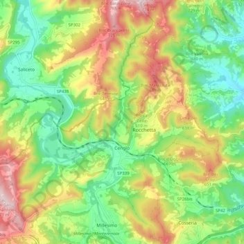
Name: Cengio topographic map, elevation, terrain.

Location: Cengio, Savona, Liguria, 17056, Italy (44.36928 8.14764 44.42631 8.24777)

Average elevation: 1,660 ft

Minimum elevation: 1,093 ft

Maximum elevation: 2,493 ft

Other topographic maps

Click on a map to view its topography, its elevation and its terrain.

Vara Superiore

Italy > Liguria > Savona

Average elevation: 2,687 ft

Perru

Italy > Liguria > Savona > Albisola Superiore

Average elevation: 1,207 ft

Montefreddo

Italy > Liguria > Savona > Mallare

Average elevation: 1,726 ft

Praie

Italy > Liguria > Savona > Piana Crixia

Average elevation: 1,125 ft

San Giuseppe di Cairo

Italy > Liguria > Savona > Cairo Montenotte

Average elevation: 1,293 ft

Riofreddo

Italy > Liguria > Savona

Average elevation: 2,677 ft

Santa Giulia

Italy > Liguria > Savona > Dego

Average elevation: 1,804 ft

Armati

Italy > Liguria > Savona > Stellanello

Average elevation: 1,401 ft

Villarelli

Italy > Liguria > Savona > Stellanello

Average elevation: 1,102 ft

Varigotti

Italy > Liguria > Savona > Finale Ligure

Average elevation: 328 ft

Bardino Nuovo

Italy > Liguria > Savona

Average elevation: 935 ft

Costa dei Ginestri

Italy > Liguria > Savona > Bergeggi

Average elevation: 266 ft

Varigotti

Italy > Liguria > Savona > Finale Ligure

Average elevation: 328 ft

Monte Agri

Italy > Liguria > Savona > Savona

Average elevation: 1,037 ft

Gear up for your next adventure:

🪶Wildlife Field Guides - Learn animal tracking and species ID
👟Men's Trail Runners - Lightweight footwear for fast-paced exploration and light hiking
🏕️Tent Footprint - Protect your tent base from wear
🖼️Topo Map Wall Art - Decorative topographic prints of famous peaks and regions
Backpacking Tent - Lightweight and durable tent for multi‑day hikes

As an Amazon Associate, this site earns from qualifying purchases at no extra cost to you.