
Thank you for supporting this site ❤️
Make a donation
Make a donation
Gear up for your next adventure:
As an Amazon Associate, this site earns from qualifying purchases at no extra cost to you.
扎古录镇 topographic map
Click on the map to display elevation.
Thank you for supporting this site ❤️
Make a donation
Make a donation
Gear up for your next adventure:
As an Amazon Associate, this site earns from qualifying purchases at no extra cost to you.
About this map
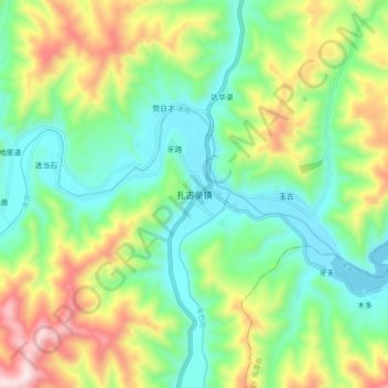
Name: 扎古录镇 topographic map, elevation, terrain.
Location: 扎古录镇, 卓尼县, 甘南藏族自治州, 甘肃省, 中国 (34.61406 103.14573 34.69406 103.22573)
Average elevation: 9,580 ft
Minimum elevation: 8,757 ft
Maximum elevation: 11,171 ft
Thank you for supporting this site ❤️
Make a donation
Make a donation
Gear up for your next adventure:
As an Amazon Associate, this site earns from qualifying purchases at no extra cost to you.
Other topographic maps
Click on a map to view its topography, its elevation and its terrain.