
申藏镇 topographic map
Interactive map
Click on the map to display elevation.
About this map
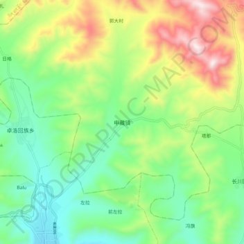
Name: 申藏镇 topographic map, elevation, terrain.
Location: 申藏镇, 卓尼县, 甘南藏族自治州, 甘肃省, 中国 (34.69465 103.34035 34.77465 103.42035)
Average elevation: 9,987 ft
Minimum elevation: 9,104 ft
Maximum elevation: 11,611 ft
Other topographic maps
Click on a map to view its topography, its elevation and its terrain.