
Make a donation
Gear up for your next adventure:
As an Amazon Associate, this site earns from qualifying purchases at no extra cost to you.
独龙江乡 topographic map
Click on the map to display elevation.
Make a donation
Gear up for your next adventure:
As an Amazon Associate, this site earns from qualifying purchases at no extra cost to you.
About this map
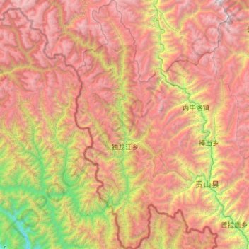
Name: 独龙江乡 topographic map, elevation, terrain.
Location: 独龙江乡, 贡山独龙族怒族自治县, 怒江傈僳族自治州, 云南省, 中国 (27.51006 98.13205 28.39710 98.50522)
Average elevation: 9,993 ft
Minimum elevation: 1,913 ft
Maximum elevation: 19,413 ft
Make a donation
Gear up for your next adventure:
As an Amazon Associate, this site earns from qualifying purchases at no extra cost to you.
Other topographic maps
Click on a map to view its topography, its elevation and its terrain.
Make a donation
Gear up for your next adventure:
As an Amazon Associate, this site earns from qualifying purchases at no extra cost to you.
嘎娃嘎普峰
中国 > 云南省 > 贡山独龙族怒族自治县
高黎贡山(独龙语:Lunggeui lvka /luŋ³¹gɯi⁵³ lə³¹kɑ⁵⁵/;载瓦语:Gauri…
Average elevation: 14,304 ft
Make a donation
Gear up for your next adventure:
As an Amazon Associate, this site earns from qualifying purchases at no extra cost to you.