
Make a donation
Gear up for your next adventure:
As an Amazon Associate, this site earns from qualifying purchases at no extra cost to you.
Champua topographic map
Click on the map to display elevation.
Make a donation
Gear up for your next adventure:
As an Amazon Associate, this site earns from qualifying purchases at no extra cost to you.
About this map
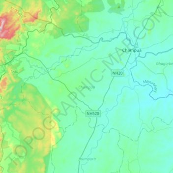
Name: Champua topographic map, elevation, terrain.
Location: Champua, Kendujhar District, Odisha, India (21.91697 85.46896 22.09582 85.77643)
Average elevation: 1,453 ft
Minimum elevation: 1,171 ft
Maximum elevation: 2,956 ft
Make a donation
Gear up for your next adventure:
As an Amazon Associate, this site earns from qualifying purchases at no extra cost to you.
Other topographic maps
Click on a map to view its topography, its elevation and its terrain.
Jajpur
Jajpur is located at 20°51′N 86°20′E / 20.85°N 86.33°E / 20.85; 86.33 and has an average elevation of 8 metres (26 ft). The climate of Jajpur District is normal as per Indian standards. All the seasons arrive in the District at their usual time. The District's average height from the sea level…
Average elevation: 46 ft
Phulbani
India > Odisha > Phulabani Town
Phulbani is located at 20°28′N 84°14′E / 20.47°N 84.23°E / 20.47; 84.23. It has an average elevation of 485 metres (1591 feet).
Average elevation: 1,703 ft
Make a donation
Gear up for your next adventure:
As an Amazon Associate, this site earns from qualifying purchases at no extra cost to you.
Bargarh
Bargarh is located in Western Odisha, close to the border of neighboring state of Chhattisgarh. It is positioned at 21°20′N 83°37′E / 21.33°N 83.62°E / 21.33; 83.62 with an average elevation of 171 meter (561 feet). The Bargarh district lies in the Plain with Eastern Ghats running close to the…
Average elevation: 568 ft
Make a donation
Gear up for your next adventure:
As an Amazon Associate, this site earns from qualifying purchases at no extra cost to you.
Make a donation
Gear up for your next adventure:
As an Amazon Associate, this site earns from qualifying purchases at no extra cost to you.
Make a donation
Gear up for your next adventure:
As an Amazon Associate, this site earns from qualifying purchases at no extra cost to you.
Make a donation
Gear up for your next adventure:
As an Amazon Associate, this site earns from qualifying purchases at no extra cost to you.
Make a donation
Gear up for your next adventure:
As an Amazon Associate, this site earns from qualifying purchases at no extra cost to you.