
Make a donation
Gear up for your next adventure:
As an Amazon Associate, this site earns from qualifying purchases at no extra cost to you.
Ramgarh topographic map
Click on the map to display elevation.
Make a donation
Gear up for your next adventure:
As an Amazon Associate, this site earns from qualifying purchases at no extra cost to you.
About this map
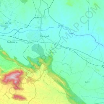
Name: Ramgarh topographic map, elevation, terrain.
Location: Ramgarh, Jharkhand, India (23.53444 85.41517 23.66363 85.63695)
Average elevation: 1,398 ft
Minimum elevation: 951 ft
Maximum elevation: 3,392 ft
Make a donation
Gear up for your next adventure:
As an Amazon Associate, this site earns from qualifying purchases at no extra cost to you.
Other topographic maps
Click on a map to view its topography, its elevation and its terrain.
Dumri
In the southern portion of Gumla district, there are flat topped hills called pat, with an elevation ranging from 2,500 feet to 3,000 feet. The pat region is spread across Bishunpur, Chainpur and Ghaghra CD blocks. The highest areas are Netarhat pat (3,356 ft), Lamiti pat (3,777 ft) and Galgat pat (3,823 ft).…
Average elevation: 2,454 ft
Make a donation
Gear up for your next adventure:
As an Amazon Associate, this site earns from qualifying purchases at no extra cost to you.
Make a donation
Gear up for your next adventure:
As an Amazon Associate, this site earns from qualifying purchases at no extra cost to you.
Make a donation
Gear up for your next adventure:
As an Amazon Associate, this site earns from qualifying purchases at no extra cost to you.
Make a donation
Gear up for your next adventure:
As an Amazon Associate, this site earns from qualifying purchases at no extra cost to you.
Giridih
Giridih is located at 24°11′N 86°18′E / 24.18°N 86.3°E / 24.18; 86.3. It has an average elevation of 289 metres (948 ft). Śrī Sammed Shikharji also known as the Parasnath Hills, located in Giridih district is the highest mountain peak in Jharkhand. It is a conical granite peak located 4,477…
Average elevation: 958 ft
Make a donation
Gear up for your next adventure:
As an Amazon Associate, this site earns from qualifying purchases at no extra cost to you.
Make a donation
Gear up for your next adventure:
As an Amazon Associate, this site earns from qualifying purchases at no extra cost to you.
Make a donation
Gear up for your next adventure:
As an Amazon Associate, this site earns from qualifying purchases at no extra cost to you.
Make a donation
Gear up for your next adventure:
As an Amazon Associate, this site earns from qualifying purchases at no extra cost to you.
Medininagar
India > Jharkhand > Medininagar(Daltonganj) > Medininagar
Medininagar is located at 24°02′N 84°04′E / 24.03°N 84.07°E / 24.03; 84.07. It has an average elevation of 215 m (705 ft).
Average elevation: 741 ft
Make a donation
Gear up for your next adventure:
As an Amazon Associate, this site earns from qualifying purchases at no extra cost to you.
Make a donation
Gear up for your next adventure:
As an Amazon Associate, this site earns from qualifying purchases at no extra cost to you.