
Make a donation
Gear up for your next adventure:
As an Amazon Associate, this site earns from qualifying purchases at no extra cost to you.
Double Horn topographic map
Click on the map to display elevation.
Make a donation
Gear up for your next adventure:
As an Amazon Associate, this site earns from qualifying purchases at no extra cost to you.
Double Horn
The original settlement of Double Horn was established near the headwaters of Double Horn Creek in 1855, with the creek and town named for an incident where a pioneer found the remains of two bucks with interlocked antlers. It had a post office from 1857 to 1911, a school (the Double Horn School), a cotton gin, and two churches. In 1884, the population was 50; by 1896, this population had halved, and by 1936, only the school remained marked on state road maps. Double Horn had completely disappeared from maps as a separate community by the second half of the 20th century. This location is close to a lightly populated ranching area marked on modern topographic maps as Shovel Mountain.
Make a donation
Gear up for your next adventure:
As an Amazon Associate, this site earns from qualifying purchases at no extra cost to you.
About this map
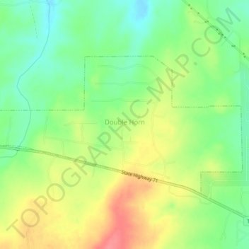
Name: Double Horn topographic map, elevation, terrain.
Location: Double Horn, Burnet County, Texas, United States (30.48668 -98.24417 30.50651 -98.20258)
Average elevation: 942 ft
Minimum elevation: 830 ft
Maximum elevation: 1,079 ft
Burnet County trails, hiking, mountain biking, running and outdoor activities
Make a donation
Gear up for your next adventure:
As an Amazon Associate, this site earns from qualifying purchases at no extra cost to you.
Other topographic maps
Click on a map to view its topography, its elevation and its terrain.
Marble Falls
United States > Texas > Burnet County > Marble Falls > Marble Falls
Average elevation: 856 ft
Make a donation
Gear up for your next adventure:
As an Amazon Associate, this site earns from qualifying purchases at no extra cost to you.