Geolocate

Spider Mountain topographic map

Click on the map to display elevation.

About this map

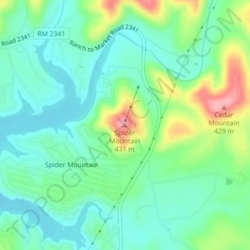
Name: Spider Mountain topographic map, elevation, terrain.

Location: Spider Mountain, Burnet County, Texas, United States (30.83485 -98.33841 30.83495 -98.33831)

Average elevation: 1,122 ft

Minimum elevation: 1,001 ft

Maximum elevation: 1,411 ft

Burnet County trails, hiking, mountain biking, running and outdoor activities

Other topographic maps

Click on a map to view its topography, its elevation and its terrain.

Lake Buchanan

United States > Texas > Burnet County

Average elevation: 1,191 ft

Highland Haven

United States > Texas > Burnet County

Average elevation: 850 ft

Burnet

United States > Texas > Burnet County

Average elevation: 1,325 ft

Meadowlakes

United States > Texas > Burnet County

Average elevation: 791 ft

Bertram

United States > Texas > Burnet County

Average elevation: 1,220 ft

Granite Shoals

United States > Texas > Burnet County

Average elevation: 863 ft

Double Horn

United States > Texas > Burnet County

The original settlement of Double Horn was established near the headwaters of Double Horn Creek in 1855, with the creek and town named for an incident where a pioneer found the remains of two bucks with interlocked antlers. It had a post office from 1857 to 1911, a school (the Double Horn School), a cotton…

Average elevation: 942 ft

Inks Lake

United States > Texas > Burnet County > Laguna Vista

Average elevation: 981 ft

Gear up for your next adventure:

🔥Plasma Lighters - Windproof lighters that work in any weather condition
🔭Stargazing Telescopes - Perfect for camping in low-light pollution areas shown on maps
🧺Microfiber Travel Towels - Compact and fast-drying towels for trail use
🩹Survival Bandages - High‑quality bandages for emergencies
🧢Sun Protection Hats - Wide-brimmed and UPF-rated hats for high-altitude sun safety

As an Amazon Associate, this site earns from qualifying purchases at no extra cost to you.