
Binangonan topographic map
Interactive map
Click on the map to display elevation.
About this map
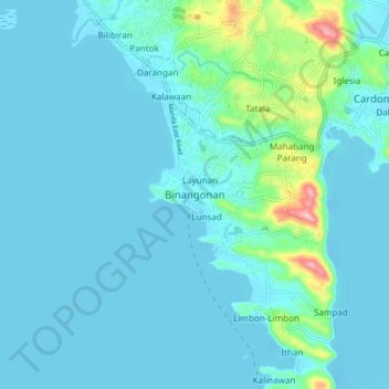
Name: Binangonan topographic map, elevation, terrain.
Location: Binangonan, Rizal, Calabarzon, 1940, Philippines (14.42514 121.15212 14.50514 121.23212)
Average elevation: 69 ft
Minimum elevation: -16 ft
Maximum elevation: 600 ft
Other topographic maps
Click on a map to view its topography, its elevation and its terrain.
San Mateo
San Mateo, Rizal, Calabarzon, 1631, Philippines
Average elevation: 223 ft
Ginoong Sanay
Philippines > Rizal > Binangonan
Ginoong Sanay, Binangonan, Rizal, Calabarzon, Philippines
Average elevation: 184 ft
Limbon-limbon
Philippines > Rizal > Binangonan
Limbon-limbon, Binangonan, Rizal, Calabarzon, 1940, Philippines
Average elevation: 72 ft
Bagumbong
Philippines > Rizal > Jalajala
Bagumbong, Jalajala, Rizal, Calabarzon, 1990, Philippines
Average elevation: 233 ft
Boso-boso River
Philippines > Rizal > Antipolo > San Joseph
Boso-boso River, San Joseph, Antipolo, Rizal, Calabarzon, 1870, Philippines
Average elevation: 846 ft
West Maarat
Philippines > Rizal > San Mateo
West Maarat, San Mateo, Rizal, Calabarzon, 1850, Philippines
Average elevation: 912 ft
Summer Green Subd. Phase II
Philippines > Rizal > Cainta
Summer Green Subd. Phase II, Cainta, Rizal, Calabarzon, 1900, Philippines
Average elevation: 26 ft
Pantok
Philippines > Rizal > Binangonan
Pantok, Binangonan, Rizal, Calabarzon, 1903, Philippines
Average elevation: 92 ft
Wawa
Philippines > Rizal > Pililla
Wawa, Pililla, Rizal, Calabarzon, Philippines
Average elevation: 43 ft
Tanay River
Philippines > Rizal > Tanay
Tanay River, Tanay, Rizal, Calabarzon, 1980, Philippines
Average elevation: 108 ft
Wawa Dam
Philippines > Rizal > Wawa
Wawa Dam, Wawa, Rizal, Calabarzon, 1860, Philippines
Average elevation: 512 ft
Pag-asa
Philippines > Rizal > Binangonan
Pag-asa, Binangonan, Rizal, Calabarzon, 1930, Philippines
Average elevation: 115 ft
Cainta, Rizal
Philippines > Rizal > Goldland Eastwood
Cainta, Rizal, Goldland Eastwood, Rizal, Calabarzon, 1900, Philippines
Average elevation: 148 ft
Ithan
Philippines > Rizal > Binangonan
Ithan, Binangonan, Rizal, Calabarzon, 1940, Philippines
Average elevation: 52 ft
Tayabasan River
Tayabasan River, Rizal, Calabarzon, Philippines
Average elevation: 1,316 ft
Bantayog ng mga Bayani
Philippines > Rizal > Cainta
Bantayog ng mga Bayani, Youngstown Village, Cainta, Rizal, Calabarzon, 1900, Philippines
Average elevation: 33 ft
Mahabang Parang
Mahabang Parang, Rizal, Calabarzon, 1904, Philippines
Average elevation: 141 ft
Muzon
Philippines > Rizal > Taytay
Muzon, Taytay, Rizal, Calabarzon, 1920, Philippines
Average elevation: 92 ft
Cuyambay
Cuyambay, Rizal, Calabarzon, 1964, Philippines
Average elevation: 1,585 ft
Beverly Hills
Beverly Hills, Rizal, Calabarzon, 1910, Philippines
Average elevation: 433 ft
San Roque
San Roque, Rizal, Calabarzon, 1910, Philippines
Average elevation: 571 ft
Del Remedio
Del Remedio, Rizal, Calabarzon, 1904, Philippines
Average elevation: 105 ft
Montalban River
Philippines > Rizal > San Isidro
Montalban River, San Isidro, Rizal, Calabarzon, 1631, Philippines
Average elevation: 732 ft
Marikina River
Marikina River, Eastern Manila District, Rizal, Metro Manila, 1804, Philippines
Average elevation: 289 ft
San Carlos
Philippines > Rizal > Binangonan
San Carlos, Binangonan, Rizal, Calabarzon, 1930, Philippines
Average elevation: 148 ft
Amiya Raya
Philippines > Rizal > Amiya Raya
Amiya Raya, Rizal, Calabarzon, 1850, Philippines
Average elevation: 499 ft
Boso-boso River
Philippines > Rizal > Antipolo
Boso-boso River, Antipolo, Rizal, Calabarzon, 1870, Philippines
Average elevation: 755 ft
San Isidro
Philippines > Rizal > Antipolo
San Isidro, Antipolo, Rizal, Calabarzon, 1870, Philippines
Average elevation: 630 ft
Old Boso-boso
Old Boso-boso, Rizal, Calabarzon, Philippines
Average elevation: 758 ft
Macabud
Philippines > Rizal > Macabud
Macabud, Rizal, Calabarzon, Philippines
Average elevation: 738 ft
San Roque
Philippines > Rizal > Antipolo
San Roque, Antipolo, Rizal, Calabarzon, 1870, Philippines
Average elevation: 568 ft
Bagumbong
Philippines > Rizal > Bagumbong
Bagumbong, Rizal, Calabarzon, Philippines
Average elevation: 112 ft