
St Albans topographic map
Click on the map to display elevation.
St Albans
The borough consisted of the ancient parish of St Albans (also known as the Abbey parish) and parts of the parishes of St Michael and St Peter. The borough was reformed by the Municipal Corporations Act 1835 to become a municipal borough, and the boundary was adjusted to additionally include part of the parish of St Stephen. On 28 August 1877 the borough gained city status, following the elevation of St Albans Abbey to become a cathedral. The boundary was also adjusted in 1877 to include part of the parish of Sandridge.
About this map
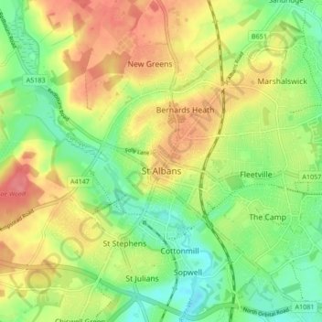
Name: St Albans topographic map, elevation, terrain.
Location: St Albans, Hertfordshire, England, United Kingdom (51.72913 -0.37529 51.78007 -0.29102)
Average elevation: 338 ft
Minimum elevation: 226 ft
Maximum elevation: 463 ft
Other topographic maps
Click on a map to view its topography, its elevation and its terrain.
St Albans
United Kingdom > England > Hertfordshire > St Albans
St Albans was an ancient borough created following the dissolution of the monastery in 1539. It consisted of the ancient parish of St Albans (also known as the Abbey parish) and parts of St Michael and St Peter. The municipal corporation was reformed by the Municipal Corporations Act 1835 and the boundary was…
Average elevation: 328 ft
Welwyn Garden City
United Kingdom > England > Hertfordshire > Welwyn Hatfield
Average elevation: 292 ft
Great Wymondley
United Kingdom > England > Hertfordshire > North Hertfordshire
Average elevation: 285 ft
Bentley Heath
United Kingdom > England > Hertfordshire > Hertsmere > Potters Bar
Average elevation: 344 ft
Spellbrook
United Kingdom > England > Hertfordshire > East Hertfordshire > Sawbridgeworth
Average elevation: 233 ft
Highfield Park
United Kingdom > England > Hertfordshire > St Albans > Colney Heath
Average elevation: 285 ft
Hertingfordbury
United Kingdom > England > Hertfordshire > East Hertfordshire
Average elevation: 200 ft
Letchworth
United Kingdom > England > Hertfordshire > North Hertfordshire > Letchworth
Average elevation: 262 ft
Astonbury Wood
United Kingdom > England > Hertfordshire > East Hertfordshire > Aston
Average elevation: 272 ft
Ashbrook
United Kingdom > England > Hertfordshire > North Hertfordshire > St Ippolyts
Average elevation: 279 ft
Long Marston
United Kingdom > England > Hertfordshire > Dacorum > Long Marston
Average elevation: 302 ft
Waterford
United Kingdom > England > Hertfordshire > East Hertfordshire > Waterford
Average elevation: 217 ft
Ellenbrook Fields
United Kingdom > England > Hertfordshire > Welwyn Hatfield > Hatfield
Average elevation: 262 ft
Windmill Hill
United Kingdom > England > Hertfordshire > North Hertfordshire > Hitchin
Average elevation: 243 ft
Primrosehill
United Kingdom > England > Hertfordshire > Three Rivers > Abbots Langley
Average elevation: 364 ft
Saint Margarets Copse
United Kingdom > England > Hertfordshire > Dacorum > Great Gaddesden
Average elevation: 472 ft
Mardley Heath
United Kingdom > England > Hertfordshire > Welwyn Hatfield > Oaklands
Average elevation: 361 ft
Throcking
United Kingdom > England > Hertfordshire > East Hertfordshire > Buntingford
Average elevation: 413 ft
Hammerfield
United Kingdom > England > Hertfordshire > Dacorum > Hemel Hempstead
Average elevation: 400 ft
Temple Dinsley
United Kingdom > England > Hertfordshire > North Hertfordshire > Preston
Average elevation: 407 ft
Bendish
United Kingdom > England > Hertfordshire > North Hertfordshire > Breachwood Green
Average elevation: 420 ft
Gobions Pond
United Kingdom > England > Hertfordshire > Welwyn Hatfield > Brookmans Park > Swanley Bar
Average elevation: 348 ft
Blackmore End
United Kingdom > England > Hertfordshire > St Albans > Wheathampstead
Average elevation: 374 ft
Tewin Wood
United Kingdom > England > Hertfordshire > East Hertfordshire > Burnham Green
Average elevation: 331 ft
Tringford Reservoir
United Kingdom > England > Hertfordshire > Dacorum > Tring > Wilstone
Average elevation: 390 ft
Knebworth Country Park
United Kingdom > England > Hertfordshire > North Hertfordshire > Knebworth
Average elevation: 381 ft
Amwell
United Kingdom > England > Hertfordshire > St Albans > Wheathampstead
Average elevation: 348 ft
Little Heath
United Kingdom > England > Hertfordshire > Dacorum > Potten End
Average elevation: 453 ft
Chapmore End
United Kingdom > England > Hertfordshire > East Hertfordshire > Tonwell
Average elevation: 213 ft
Stanstead St Margarets
United Kingdom > England > Hertfordshire > East Hertfordshire
Average elevation: 157 ft
Hadham Cross
United Kingdom > England > Hertfordshire > East Hertfordshire > Much Hadham
Average elevation: 259 ft
Thorley Street
United Kingdom > England > Hertfordshire > East Hertfordshire > Thorley
Average elevation: 243 ft
Peter's Green
United Kingdom > England > Hertfordshire > North Hertfordshire > Kimpton
Average elevation: 436 ft
Pimlico
United Kingdom > England > Hertfordshire > Three Rivers > Abbots Langley
Average elevation: 404 ft
The Rookery
United Kingdom > England > Hertfordshire > Three Rivers > Abbots Langley > Langleybury
Average elevation: 302 ft
Dixon's Gap Bridge
United Kingdom > England > Hertfordshire > Dacorum > Wilstone > Gubblecote
Average elevation: 331 ft
Whempstead
United Kingdom > England > Hertfordshire > East Hertfordshire > Dane End
Average elevation: 312 ft
Stanborough Park
United Kingdom > England > Hertfordshire > Welwyn Hatfield > Hatfield > Stanborough
Average elevation: 259 ft
Sarratt Bottom
United Kingdom > England > Hertfordshire > Three Rivers > Sarratt
Average elevation: 367 ft
Bushey
United Kingdom > England > Hertfordshire > Hertsmere
Bushey is a town in the Hertsmere borough of Hertfordshire in the East of England. It had a population of 25,328 in the 2011 census, rising to 28,416 in the 2021 census, an increase of 12.19%. This makes Bushey the second most populated town in Hertsmere. Bushey Heath is a large neighbourhood south east of…
Average elevation: 289 ft
Church End
United Kingdom > England > Hertfordshire > East Hertfordshire > Little Hadham
Average elevation: 312 ft