
Make a donation
Gear up for your next adventure:
As an Amazon Associate, this site earns from qualifying purchases at no extra cost to you.
Annweiler am Trifels topographic map
Click on the map to display elevation.
Make a donation
Gear up for your next adventure:
As an Amazon Associate, this site earns from qualifying purchases at no extra cost to you.
About this map
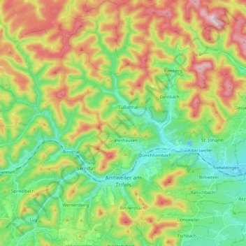
Name: Annweiler am Trifels topographic map, elevation, terrain.
Average elevation: 1,115 ft
Minimum elevation: 482 ft
Maximum elevation: 2,146 ft
Make a donation
Gear up for your next adventure:
As an Amazon Associate, this site earns from qualifying purchases at no extra cost to you.
Other topographic maps
Click on a map to view its topography, its elevation and its terrain.
Haardt
Deutschland > Rheinland-Pfalz > Landkreis Südliche Weinstraße > Maikammer
Im Westen wird der Gebirgszug durch die Lambrechter Verwerfung vom inneren Pfälzerwald abgegrenzt. Diese nach der Stadt Lambrecht benannte Störungslinie verläuft in einem Abstand von etwa 2 bis 5 km parallel zum Grabenrand und hat zur Versetzung verschiedener Gesteinsschichten um 80 bis 100 m geführt.…
Average elevation: 1,588 ft
Madenburg
Deutschland > Rheinland-Pfalz > Landkreis Südliche Weinstraße > Waldhambach
Die Madenburg wurde als Höhenburg am Ostrand des Pfälzerwalds auf einem in die Rheinebene vorspringenden Felsausläufer des 476,3 m hohen Rothenbergs erbaut. Die von Wald umgebene Ruine liegt etwa 250 m oberhalb von Eschbach auf einer Höhe von 458,5 m ü. NHN.
Average elevation: 951 ft
Sankt Martin
Deutschland > Rheinland-Pfalz > Landkreis Südliche Weinstraße > Sankt Martin > Sankt Martin
Sankt Martin lebt überwiegend vom Wein der auf etwa 200 Hektar in den beiden Einzellagen Baron und Kirchberg – beide Bestandteil der Großlage Schloß Ludwigshöhe – angebaut wird. Der Ort ist Teil des Weinanbaugebiet Pfalz. Damit verbundenen ist das Tourismusaufkommen ebenfalls ein bedeutender…
Average elevation: 1,010 ft
Make a donation
Gear up for your next adventure:
As an Amazon Associate, this site earns from qualifying purchases at no extra cost to you.
Hüttenhohl
Deutschland > Rheinland-Pfalz > Landkreis Südliche Weinstraße > Maikammer
Average elevation: 1,650 ft
Kalmit
Deutschland > Rheinland-Pfalz > Landkreis Südliche Weinstraße > Maikammer
Die Kalmit [ˈkalmɪt], regional auch der Kalmit, seltener auch Große Kalmit genannt, bei Maikammer im rheinland-pfälzischen Landkreis Südliche Weinstraße ist mit einer Höhe von 673,64 m ü. NHN der höchste Berg des Pfälzerwalds und nach dem Donnersberg der zweithöchste Gipfel der Region Pfalz.…
Average elevation: 1,581 ft
Make a donation
Gear up for your next adventure:
As an Amazon Associate, this site earns from qualifying purchases at no extra cost to you.
Kleine Kalmit
Deutschland > Rheinland-Pfalz > Landkreis Südliche Weinstraße > Landau in der Pfalz
Average elevation: 705 ft
Reichsburg Trifels
Deutschland > Rheinland-Pfalz > Landkreis Südliche Weinstraße > Annweiler am Trifels > Bindersbach
Die Höhenburg Trifels auf der Waldgemarkung von Annweiler steht auf einem dreifach gespaltenen Buntsandsteinfelsen, der 145 m lang, 40 m breit und 50 m hoch ist und die Kuppe des 479 m hohen Sonnenbergs bildet. Von dieser steinernen Basis stammt der Name Trifels, was „dreifacher Fels“ bedeutet. Der…
Average elevation: 974 ft
Make a donation
Gear up for your next adventure:
As an Amazon Associate, this site earns from qualifying purchases at no extra cost to you.
Lindelbrunn
Deutschland > Rheinland-Pfalz > Landkreis Südliche Weinstraße > Vorderweidenthal > Lindelbrunn
Der Knappe Punker von Rohrbach diente einst dem Ritter auf der Burg und leistete ihm gute Dienste. So bat er eines Tages seinen Herrn, ihn zum Junker zu machen. Als ihm der Ritter dies verweigerte, verließ er die Burg und trat in die Armee des Pfalzgrafen Ludwig III. ein, welcher der Bärtigen genannt wurde.…
Average elevation: 1,040 ft
Hohe Derst
Deutschland > Rheinland-Pfalz > Landkreis Südliche Weinstraße > Böllenborn
Average elevation: 1,299 ft
Kesselberg
Deutschland > Rheinland-Pfalz > Landkreis Südliche Weinstraße > Rhodt unter Rietburg
Average elevation: 1,542 ft
Orensberg
Deutschland > Rheinland-Pfalz > Landkreis Südliche Weinstraße > Böchingen
Um die Höhenkuppe des Berges zieht sich ein als Kulturdenkmal eingestufter Ringwall. Auf dem höchsten Bereich des Südsporns (564,5 m) steht der als Naturdenkmal ausgewiesene Orensfelsen.
Average elevation: 1,237 ft
Make a donation
Gear up for your next adventure:
As an Amazon Associate, this site earns from qualifying purchases at no extra cost to you.
Rehberg
Deutschland > Rheinland-Pfalz > Landkreis Südliche Weinstraße > Waldrohrbach
Der Rehberg erhebt sich als kegelförmiger Einzelberg im nordöstlichen Wasgau unmittelbar südwestlich über dem Annweilerer Ortsteil Bindersbach. Im Süden wird der Berg begrenzt durch das Tal des Kaiserbachs mit der Gemeinde Waldrohrbach. Er hat eine ovale Grundfläche mit einem Durchmesser von 1 bis 2 km…
Average elevation: 1,093 ft
Roßberg
Deutschland > Rheinland-Pfalz > Landkreis Südliche Weinstraße > Burrweiler
Average elevation: 1,332 ft
Steigerkopf
Deutschland > Rheinland-Pfalz > Landkreis Südliche Weinstraße > Gommersheim
Ein südlich des Gipfels auf 525,5 m Höhe gelegener Bergsattel heißt Benderplatz nach dem Oberlehrer Friedrich Bender (1869–1932), der die Ortsgruppe Edenkoben des Pfälzerwald-Vereins gegründet hat. Am Rand des Platzes stehen der Ritterstein 241 mit Angaben zu Bender und eine kleine hölzerne…
Average elevation: 1,644 ft
Blättersberg
Deutschland > Rheinland-Pfalz > Landkreis Südliche Weinstraße > Rhodt unter Rietburg
Die Höhe des Blättersbergs wird im Rahmen seiner Nordkuppe auf topographischen Karten mit 613,2 m teils aber auch mit 617,5 m angegeben. Etwa 60 m südöstlich des Berggipfels liegt eine 611,8 m hohe Stelle und auf der Südkuppe (606 m) nahe dem Ludwigsturm eine solche auf 604,9 m Höhe. Der Hauptgipfel ist…
Average elevation: 1,391 ft
Make a donation
Gear up for your next adventure:
As an Amazon Associate, this site earns from qualifying purchases at no extra cost to you.
Edesheim
Deutschland > Rheinland-Pfalz > Landkreis Südliche Weinstraße > Edesheim > Edesheim
Average elevation: 528 ft
Bindersbach
Deutschland > Rheinland-Pfalz > Landkreis Südliche Weinstraße > Annweiler am Trifels > Bindersbach
Average elevation: 1,047 ft
Impflingen
Deutschland > Rheinland-Pfalz > Landkreis Südliche Weinstraße > Impflingen > Impflingen
Average elevation: 538 ft
Essingen
Deutschland > Rheinland-Pfalz > Landkreis Südliche Weinstraße > Essingen > Essingen
Average elevation: 476 ft
Make a donation
Gear up for your next adventure:
As an Amazon Associate, this site earns from qualifying purchases at no extra cost to you.