
Make a donation
Gear up for your next adventure:
As an Amazon Associate, this site earns from qualifying purchases at no extra cost to you.
Etah topographic map
Click on the map to display elevation.
Make a donation
Gear up for your next adventure:
As an Amazon Associate, this site earns from qualifying purchases at no extra cost to you.
Etah
Eta is located at 27.63 ° N 78.67 ° E. [4] It has an average elevation of 170 m (557 ft). The Eisen River flows behind the village Ghazipur Pahor. Etah is a district in the Aligarh division of Uttar Pradesh province, India. It is bounded by Kasganj in the north, Mainpuri and Firozabad in the south, Farrakhabad in the east and Aligarh, Hathras, Mathura and Agra districts in the west. Which come in Uttar Pradesh. The district does not have a border with any other state.
Make a donation
Gear up for your next adventure:
As an Amazon Associate, this site earns from qualifying purchases at no extra cost to you.
About this map
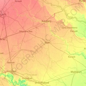
Name: Etah topographic map, elevation, terrain.
Location: Etah, Uttar Pradesh, India (27.32324 78.17557 27.78521 79.27717)
Average elevation: 551 ft
Minimum elevation: 446 ft
Maximum elevation: 659 ft
Make a donation
Gear up for your next adventure:
As an Amazon Associate, this site earns from qualifying purchases at no extra cost to you.
Other topographic maps
Click on a map to view its topography, its elevation and its terrain.
Make a donation
Gear up for your next adventure:
As an Amazon Associate, this site earns from qualifying purchases at no extra cost to you.
Make a donation
Gear up for your next adventure:
As an Amazon Associate, this site earns from qualifying purchases at no extra cost to you.
Make a donation
Gear up for your next adventure:
As an Amazon Associate, this site earns from qualifying purchases at no extra cost to you.
Raebareli
India > Uttar Pradesh > Raebareli
The district forms a part of the Gangetic plain which is of recent origin according to geological chronology and reveal ordinary Gangetic alluvium. The district being a part of the alluvial plain conforms to the same geological sequence as the plain itself. The only mineral of importance is kankar. The…
Average elevation: 364 ft
Govardhan
India > Uttar Pradesh > Mathura
Govardhana is located at 27°30′N 77°28′E / 27.5°N 77.47°E / 27.5; 77.47. It has an average elevation of 179 metres (587 feet). Govardhana has been made Tehsil in Mathura District by the Uttar Pradesh government.
Average elevation: 594 ft
Make a donation
Gear up for your next adventure:
As an Amazon Associate, this site earns from qualifying purchases at no extra cost to you.
Make a donation
Gear up for your next adventure:
As an Amazon Associate, this site earns from qualifying purchases at no extra cost to you.
Sahaspur
India > Uttar Pradesh > Dhampur
Sahaspur is located at 29°07′16″N 78°37′16″E / 29.121°N 78.621°E / 29.121; 78.621. It has an average elevation of 199 metres (653 feet).
Average elevation: 712 ft